Search Results
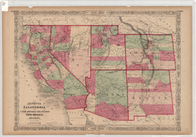
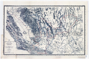
Maps of geographical surveys of parts of California, southeastern Nevada, Arizona and southwestern Utah, made under the command of George M. Wheeler, 1872-1873
Date
1872 to 1873
Description
At top of plate: 'U.S. geographical surveys west of the one-hundredth meridian. Parts of California, S.E. Nevada, Arizona & S.W. Utah.' At bottom of plate: 'Expeditions of 1872 & 1873, under the command of 1st Lieut. Geo. M. Wheeler, Corps of Engineers, U.S. Army.' 'G. K. Gilbert, A. R. Marvine, E. E. Howell, geological assistants.' 'By order of The Honorable The Secretary of War, under the direction of Brig. Gen. A. A. Humphries, Chief of Engineers, U.S. Army.' Published by Government Printing Office. 2 map sections on 1 sheet. Scale: 1 inch to 8 miles.
Image
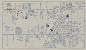
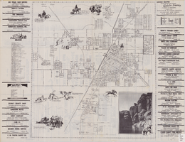
Street map of the city of Las Vegas, 1955
Date
1955
Description
20 x 35 cm., folded to 22 x 11 cm. Copyright held by Redwood Pub. Co. "Compliments of 'Buck' Evans 76 Union"--Panel. Index on verso. Includes table of mileages to Las Vegas from other cities in the Southwest. Original publisher: Redwood Publishing Co., Scale: .
Image
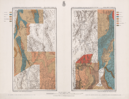
Map of parts of California, Nevada, Arizona and Utah : traversed in 1891 by the Death Valley Expedition (a biological survey conducted by the U.S. Dept. of Agriculture), C. Hart Merriam in charge
Date
1893
Description
Scale [ca. 1:1,267,200. 1 in. to approx. 20 miles] (W 122°00--W 113°00/N 38°30--N 34°00) ; 1 map : col. ; 42 x 69 cm., folded to 22 x 12 cm ; Relief shown by hachures and spot heights ; From: The Death Valley Expedition. Part II. 1893. North American fauna, no. 7 ; "Routes of Dr. C. Hart Merriam" and "Distinctive routes of other members of the expedition" overprinted in color ; Map was compiled in 1892 ; "Map no. 1."--Upper right corner ; Government Printing Office
Image
Street map of the city of Las Vegas, North Las Vegas, the "Strip", 1955
Date
1955
Description
41 x 38 cm., folded to 28 x 15 cm. Panel title: Welcome map, greater Las Vegas area. Includes inset map of Meikle Manor subdivision. Includes list of churches in Las Vegas, mileages from Las Vegas to other cities in the Southwest and notes. Helldorado ed. 1955. Map is irregularly shaped. Index and advertisements on verso. Original publisher: Adco Publishing Co..
Image
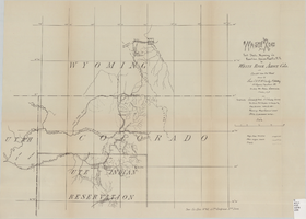
Wagon road from Fort Steele, Wyoming via Rawlins, Union Pacific R.R. to White River Agency, Colo., via cut-off from old road, October, 1878
Date
1878-10
Description
38 x 52 cm. "Topography: Colorado & Utah: U.S. Geolog. Survey Territories, Prof. Hayden in charge and from personal notes & obs--Wyoming: maps, General Land Office & personal notes." "October, 1878." Includes other wagon roads, trails, rivers, ranches, Indian agencies and military reservation. "Drawn by Lieutenant C. A. H. McCauley, 3rd Artillery." "Sen. Ex. Doc. No. 62, 45th Congress 3rd Sess." Original publisher: GPO, Series: Sen. ex. doc no. 62, 45th Congress, 3rd session.
Image

Map of Las Vegas and vicinity, Nevada, circa 1957-1961
Date
1957 to 1961
Description
70 x 68 cm. on sheet 106 x 71 cm. Includes indexes. Includes Nellis Air Force Base, Henderson, and inset maps of Boulder City, Nevada, and Las Vegas's geographical location in the Southwest. "H-654-32" on the lower right-hand corner. Page 2 contains a photograph of the Fremont Street in Downtown Las Vegas, featuring the Golden Nugget Gambling Hall and the Horseshoe Casino. Page 3 outlines local and regional attractions, as well as population information. Original publisher: R. L. Polk.
Image