Search Results
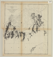
From the Great Salt Lake to the Humboldt Mountains
Date
1855
Description
'From explorations and surveys made under the direction of the Hon. Jefferson Davis, Secretary of War, by Capt. E.G. Beckwith, 3rd Artillery, E.G. Egloffstein, topographer for the route. 1855.' ''Selmar Siebert's Engraving & Printing Establishment, Washington, D.C.' Published by the War Dept. Scale 1:760,320. 12 miles to 1 in. Relief shown by hachures and spot heights.
Image
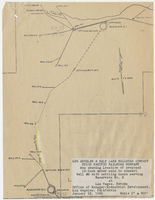
Map showing location of proposed 12-inch water main to connect Well #8 with settling basin serving Reservoir No. 2 at Las Vegas, Nevada, January 16, 1950
Date
1950-01-16
Archival Collection
Description
'Office of Manager-Industrial Development, Los Angeles, California.' Scale: 1" = 600'. 10 3/8 in. x 8 in.
Image
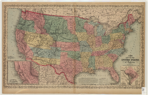
Map of the United States of America, 1859
Date
1859
Description
'Philadelphia. Published by Charles Desilver ... 1859.' Entered according to Act of Congress in the year 1856 by Charles Desilver in the Clerks office of the District Court of the Eastern District of Pennsylvania.' 'Engraved by J.L. Hazzard & E. Yeager.' Includes notes and insets titled 'Gold region of California' and 'District of Columbia.' Relief shown by hachures and spot heights. Also shows battle fields and proposed western railroad routes. Prime meridians: Washington and Greenwich. Atlas p. numbers in upper margin: 5-6. Scale 1:8,750,000 (W 126°--W 65°/N 48°--N 24°)
Image
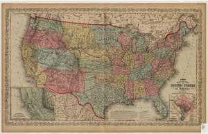
Map of the United States of America, 1856
Date
1856
Description
'Philadelphia. Published by Charles Desilver.' 'Entered according to Act of Congress in the year 1856 by Charles Desilver in the Clerks office of the District Court of the Eastern District of Pennsylvania.' 'Engraved by J.L. Hazzard & E. Yeager.' Includes notes and insets titled 'Gold region of California' and 'District of Columbia.' Relief shown by hachures and spot heights. Also shows battle fields and proposed western railroad routes. Prime meridians: Washington and Greenwich. Atlas p. numbers in upper margin: 5-6. Scale 1:8,750,000 (W 126°--W 65°/N 48°--N 24°).
Image
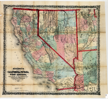
Bancroft's map of California, Nevada, Utah and Arizona, 1873
Date
1873
Description
Hand colored ; Relief shown by hachures and spot heights ; Prime meridian: Washington, D.C ; Shows railroads, proposed railroads and wagon roads, etc. Published by A.L. Bancroft & Company. Scale [ca. 1:1,520,640]. 1 in. to 24 miles (W 124°--W 111°/N 42°--N 32°).
Image
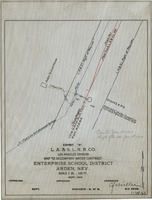
Map to accompany water contract, Enterprise School District, Arden, Nevada, September 1919
Date
1919
Archival Collection
Description
'Exhibit A. L.A. & S.L. R.R. Co., Los Angeles Division. Sept. 1919.' 'Approved [signed], C.F. Miller, Div. Engr.' 'I-W-67" hand-printed in lower right corner. 'Cancelled June 1st, 1920; Supts. file 129 - June 7th, 1920" handwritten on map. Scale: 1 in. : 100 ft.
Image

Map showing proposed new 12" well and pipe line changes at Water Springs, Las Vegas, Nevada, circa 1920
Date
1916 to 1925
Archival Collection
Description
In lower right corner: '6-W-74.' Scale: 1" = 500'.
Image
Map showing location of proposed water lines serving Industrial Tract No. 1, Las Vegas Nevada, March 21, 1931
Date
1931-03-21
Archival Collection
Description
'Office of Ind'l. Engineer, Los Angeles, California.' 'Dwg. No. 568.' Scale: 1" = 100'.
Image
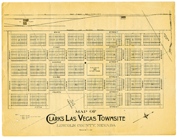
Map of Clark's Las Vegas Townsite, Lincoln County, Nevada, May 10, 1905
Date
1905-05-10
Archival Collection
Description
Scale: 1" = 100'. 1 map ; 28 x 22 cm. Verso of map is an announcement of the auction to be held May 15, 1905, for lots in the Las Vegas townsite. Pricing and lot information is included, as well as specials for railway tickets to Las Vegas from Los Angeles and Salt Like City. Las Vegas Land and Water Company
Text
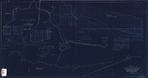
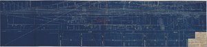
Blueprint showing proposed improvement of Las Vegas Springs, Las Vegas, Nevada, September 21, 1916
Date
1916-09-21
Archival Collection
Description
'Exhibit A'. 'Approved Sept. 21, 1916.' '2-N-1719' handwritten in lower right corner. 'W.E.J."--Lower left corner. "L-44 - 50 to 61. T-75 - 17 & 46"--Upper left corner. Includes discharge figures and plans for improvements to springs. Scale [ca. 1:240]. 1 in. to 20 feet. -- Scale [ca. 1:2,400]. 1 in. to 200 ft. Vertical scale [ca. 1:48]. 1 in. to 4 feet. -- Scale [ca. 1:4,800]. 1 in. to 100 feet. 1 map. Contents: Detail at springs -- Profile -- Alignment.
Image