Search Results

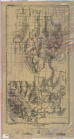
Map of California and Territories of New Mexico and Utah, 1862
Date
1862
Description
Scale [ca. 1:3,231,360. 1 in. to approx. 51 miles] (W 125°00--W 103°30/N 42°00--N 31°45) ; 1 map : hand col. ; 40 x 60 cm., on sheet 46 x 68 cm ; Relief indicated by hachures and spot heights ; Prime meridians: Greenwich and Washington, D.C ; Decorative border ; Hand colored ; Atlas p. numbers in upper margin: 58-59 ; Date est. from territorial borders and county configuration ; Shows natural features, locations of Indian tribes, proposed railroad routes, routes of explorers, trails, county boundaries and populated places ; Johnson and Ward
Image

Map of California, Utah, Nevada, Colorado, New Mexico and Arizona, 1864
Date
1864
Description
'Johnson's California, also Utah, Nevada, Colorado, New Mexico, and Arizona, published by A.J. Johnson, New York.' 'Entered according to Act of Congress in the Year 1864, by A.J. Johnson in the Clerks Office of the District Court of the United States for the Southern District of New York.' Atlas page numbers in upper margin: 66-67. Relief shown by hachures. Prime meridians: Greenwich and Washington, D.C. Shows proposed railroads, locations of Indian tribes, natural features, counties, mines, mail routes, trails and routes of exploring expeditions. On verso: History and statistics of Mexico and Central America and statistics of national finances and the Post Office of the United States, 1860. Scale [ca. 1:3,484,800. 1 in. to ca. 55 miles] (W 123°--W 103°/N 42°--N 32°)
Text

Map of California, and territories of Utah, Nevada, Colorado, New Mexico and Arizona, 1864
Date
1864
Description
'Johnson's California, also Utah, Nevada, Colorado, New Mexico, and Arizona, published by A.J. Johnson, New York.' 'Entered according to act of Congress in the year 1864, by A.J. Johnson in the Clerks Office of the District Court of the United States for the southern district of New York.' Atlas page numbers in upper margin: 67-68. Relief shown by hachures. Prime meridian: Greenwich and Washington. Shows natural features, locations of Indian tribes, proposed railroad routes, routes of explorers, trails, county boundaries and populated places. Hand colored. On verso: 'Historical and statistical view of the West India Islands or Columbian Archipelago' (p. 80) and 'Historical and statistical view of Mexico and Central America' (p. 79). Scale [ca. 1:3,484,800]. 1 in. to ca. 55 miles (W 124°--W 102°/N 42°--N 32°).
Text

Map of California, Utah, Nevada, Colorado, New Mexico and Arizona, circa 1867
Date
1865 to 1869
Description
39 x 56 cm. Relief shown by hachures. "Entered according to act of Congress in the year 1864, by A.J. Johnson in the Clerks Office of the United States for the Southern District of New York." Atlas page numbers in upper margin: 67-68. Primer meridians: Greenwich and Washington, D.C. On verso: History and statistical view of the West India islands or Columbian Archipelago and Historical and statistical view of Mexico and Central America. Shows proposed railroads, locations of Indian tribes, natural features, counties, mines, mail routes, trails and routes of exploring expeditions. Has decorative border. Southern part of Nevada was added to the state in 1867 and is part of Nevada on this map, but Lincoln County was established in 1867 and is not on this map. This map was still probably published in 1867 in spite of someone's having written "1864" in pencil in the lower right corner of the Library's copy. Original publisher: A.J. Johnson.
Image
Map of a part of southern Nevada showing ground-water conditions, 1914
Date
1914
Description
At bottom of map: 'Base compiled from plane-table sheets, topographic maps of U.S. Geological Survey, railroad alignments, and General Land Office data.' Relief shown by hachures and spot heights. Shows township and range grid. Covers from southeast corner of White Pine County to Sloan and from Nye County border to Arizona-Utah border. Shows flowing wells, nonflowing wells, springs, flowing-well areas, dry holes and shore lines of ancient lakes. Scale 1:500,000 (W116°--W 114°/N 45°--N 36°). Series: Water-supply paper (Washington, D.C.), 365. Map is plate 1 from the U.S. Geological Survey water-supply paper 365.
Image
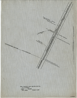
Map showing water pipeline serving H. C. Wheeler, Arden, Nevada, November 1929
Date
1929-11
Archival Collection
Description
Hand-drawn map. '2-W-214' hand-printed in lower right corner. Scale: 1" = 400'.
Image
Map of Las Vegas Valley Water District, April 16, 1953
Date
1953-04-16
Archival Collection
Description
'Exhibit A.' 'April 16, 1953. Dwg, No. I-128.' Accompanies: Bill of Sale - LA&SL L.S.D. Audit No. 5251, Contract Dept. No. 39722-3 (Box 25 Folder 80-12).
Image

Map of California, Utah, Nevada, Colorado, New Mexico and Arizona, 1864
Date
1864
Description
'Johnson's California, with Utah, Nevada, Colorado, New Mexico, and Arizona, published by Johnson and Ward.' 'Entered according to Act of Congress in the Year 1864 by A.J. Johnson in the Clerks Office of the District Court of the United States for the southern district of New York.' Atlas page numbers in upper margin: 66-67. This is probably plate 67 from Johnson's New Illustrated Family Atlas, published in New York by Johnson & Ward in 1864. Shows natural features, locations of Indian tribes, proposed railroad routes, routes of explorers, trails, county boundaries and populated places ; "." ; Relief shown by hachures ; Prime meridians: Greenwich and Washington ; In top margin: 66-67 ; Hand colored ; On verso: Historical and statistical view of Mexico and central America (p. 79) and Historical and statistical view of the United States, 1860 (p. 78) Scale [ca. 1:3,484,800]. 1 in. to ca. 55 miles (W 124°--W 102°/N 42°--N 32°)
Text
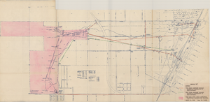
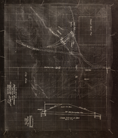
Map showing location of proposed water mains to serve Hyde Park Subdivision No. 2 at Las Vegas, Nevada, April 21, 1953
Date
1953-04-21
Archival Collection
Description
'Drawing B-617.' 'Office of Vice President, Los Angeles,California.' Accompanies: L. R. Maag letter to Thomas A. Campbell, June 15, 1953 (Box 14 Folder W26 File No. 1).
Image
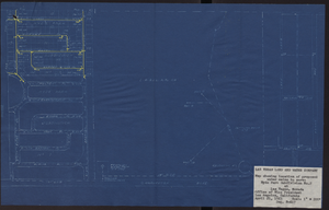
Topographic map showing proposed reservoir for the Las Vegas Rancho, August 4, 1931
Date
1931-08-04
Archival Collection
Description
'Chief Engineers Office, Los Angeles, Calif. August 4, 1931. Scale: 1"=100'. Drawn by L.P.D. 1"=10'.' Accompanies: Letter from R. L. Adamson to F. H. Knickerbocker, August 18, 1931 (Folder 6B: 18-1-9).
Image