Search Results
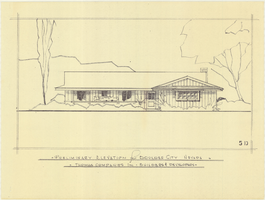
Architectural drawing of residential home in Boulder City, Nevada, preliminary elevation, 1962
Date
Archival Collection
Description
Preliminary drawing of front exterior elevation of a ranch-style residential home in Boulder City, Nevada.
Architecture Period: Mid-Century ModernistImage

Map showing second stage plan of development for Southern Nevada Water Project, March 1981
Date
Description
Image

Surficial geologic map of the Specter Range NW quadrangle, Nye County, Nevada, 1989
Date
Description
Image
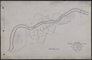
Map of proposed flood control project on the Virgin River in Clark County, Nevada, March, 1934
Date
Archival Collection
Description
Image

Blueprint showing proposed pipeline for gravity water supply at Las Vegas, Nevada, February 16, 1905
Date
Description
Image

Map of Las Vegas and vicinity, Clark County, Nevada, November 1952
Date
Description
Image
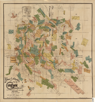
Map of the Goldfield Mining District, Nye and Esmeralda Counties, Nevada, 1905
Date
Description
Image

Topographic map of Nevada-California, Las Vegas quadrangle, March 1908
Date
Description
Text
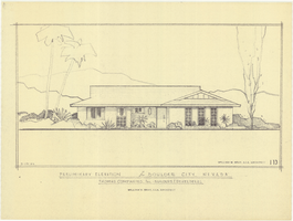
Architectural drawing of residential home in Boulder City, Nevada, preliminary elevation, September 19, 1962
Date
Archival Collection
Description
Preliminary drawing of front exterior elevation of a ranch-style residential home in Boulder City, Nevada.
Architecture Period: Mid-Century ModernistImage

General geologic map of Las Vegas, Pahrump, and Indian Spring Valleys, Clark and Nye Counties, Nevada, 1948
Date
Description
At top of map: 'United States Department of the Interior, Geological Survey. State Engineer of Nevada. Water resources bulletin No. 5, Plate 1.' Relief shown by spot heights. Includes 3 inset maps of wells and springs in the vicinity of Pahrump, Manse Ranch and Indian Springs, Nevada. Scale [ca. 1:126,720. 1 inch to approx. 2 miles] (W 116°--W 115°/N 40°--N 36°). Originally published as plate 1 in Geology and water resources of Las Vegas, Pahrump, and Indian Spring Valleys, Clark and Nye Counties, Nevada by George B. Maxey and C.H. Jameson (1948), which is number 5 of the Water resources bulletin published by the Nevada Office of the State Engineer.
Image