Search Results
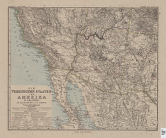
Map of Southwestern United States of America, 1888
Date
Description
Image
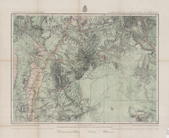
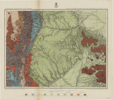
Map of economic features, part of central New Mexico, May 7, 1877
Date
Description
37 x 50 cm. Relief shown by hachures and spot heights "Atlas sheet no. 77(B)." "Issued May 7th 1877." "Expeditions of 1871 & 1786 under the command of 1st. Lieut. Geo. M. Wheeler, Corps of Engineers, U.S. Army." "Weyss, Herman & Lang, del." "By order of the honorable the Secretary of War." "Under the direction of Brig. General A. A. Hunphreys, Chief of Engineers, U. S. Army." "2nd. Ed. June 30th, 1881." Original publisher: U.S. Geographical Surveys West of the 100th Meridian, Scale: 1 inch to 4 miles or 1: 253440.
Image
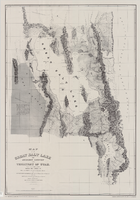
Map of the Great Salt Lake and adjacent country in the territory of Utah, 1852
Date
Description
Image
Map of Utah territory representing the extent of the irrigable, timber and pasture lands, 1878
Date
Description
Image
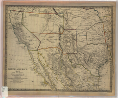
Map of Utah, New Mexico, Texas, California, Indian territory, and the northern states of Mexico, 1852
Date
Description
Image
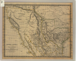
Map of Texas, California, New Mexico and the northern states of Mexico, October 15, 1842
Date
Description
Image
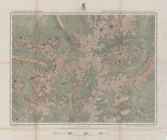
Map of economical features of Southwest Colorado, San Juan mining region, circa 1877
Date
Description
Image
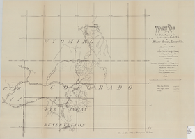
Wagon road from Fort Steele, Wyoming via Rawlins, Union Pacific R.R. to White River Agency, Colo., via cut-off from old road, October, 1878
Date
Description
Image
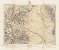
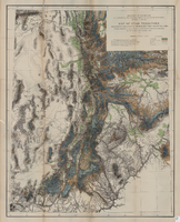
Map of part of south western Colorado, January 10, 1878
Date
Description
38 x 49 cm. Relief shown by hachures and spot heights. "Atlas sheet no. 61(D)." "Issued Jan. 10th 1878." "Expeditions of 1873, 74, 75 & 76 under the command of 1st. Lieut. Geo. M. Wheeler, Corps of Engineers, U.S. Army." Prime meridians: Washington, D.C. and Greenwich. Includes sectional diagram showing how atlas sheets fit together. "Weyss, Lang & Herman, del." "By order of the honorable the Secretary of War." "Under the direction of Brig. General A. A. Hunphreys, Chief of Engineers, U. S. Army." " J. C. Spiller, Louis Nell, topographical assistants." "Expeditions of 1873, 74, 75 & 76 under the command of 1st. Lieutenant William L. Marshall, Corps of Engineers, U. S. Army, 1st Lieutenant Eric Bergland, Corps of Engineers, U. S. Army, Executive Officers and field astronomers." Original publisher: U.S. Geographical Surveys West of the 100th Meridian, Scale 1 inch to 4 miles or 1:253440.
Image
Map of parts of southern Colorado and northern New Mexico, atlas sheet no. 70(A), 1877
Date
Description
Image