
Search the Special Collections and Archives Portal

Search Results

Display    Results Per Page
Displaying results 591 - 600 of 615

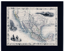
Map of Mexico, California and Texas, 1851

Date

1851

Description

'The map drawn and engraved by J. Rapkin.' Scale [ca. 1:14,256,000. 1 in. to approx. 225 miles] (W125°-- W80°/N 42°--N 15°). Relief shown by hachures. Prime meridian: Greenwich. Hand colored. Includes illustrations: Gold washing -- Mexican peasantry --Ruins at Uxmal, Yucatan. Includes decorative border. Library's copy is matted. Originally published as Map 70 of The Illustrated Atlas And Modern History Of The World, Geographical, Political, Commercial & Statistical, edited by R. Montgomery Martin, Esq., London & New York, J. & F. Tallis, 1851. Illustrated atlas and modern history of the world, geographical, political, commercial & statistical

Image

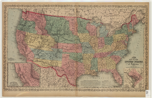
Map of the United States of America, 1859

Date

1859

Description

'Philadelphia. Published by Charles Desilver ... 1859.' Entered according to Act of Congress in the year 1856 by Charles Desilver in the Clerks office of the District Court of the Eastern District of Pennsylvania.' 'Engraved by J.L. Hazzard & E. Yeager.' Includes notes and insets titled 'Gold region of California' and 'District of Columbia.' Relief shown by hachures and spot heights. Also shows battle fields and proposed western railroad routes. Prime meridians: Washington and Greenwich. Atlas p. numbers in upper margin: 5-6. Scale 1:8,750,000 (W 126°--W 65°/N 48°--N 24°)

Image

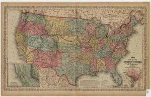
Map of the United States of America, 1856

Date

1856

Description

'Philadelphia. Published by Charles Desilver.' 'Entered according to Act of Congress in the year 1856 by Charles Desilver in the Clerks office of the District Court of the Eastern District of Pennsylvania.' 'Engraved by J.L. Hazzard & E. Yeager.' Includes notes and insets titled 'Gold region of California' and 'District of Columbia.' Relief shown by hachures and spot heights. Also shows battle fields and proposed western railroad routes. Prime meridians: Washington and Greenwich. Atlas p. numbers in upper margin: 5-6. Scale 1:8,750,000 (W 126°--W 65°/N 48°--N 24°).

Image

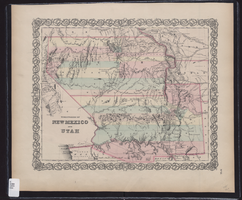
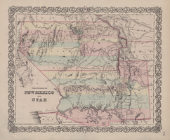
Map showing the territories of New Mexico and Utah, 1855

Date

1855

Description

'Entered according to Act of Congress in the year 1855 by J.H. Colton & Co. in the Clerk's Office of the Dist. Court of the U.S. for the South'n. Dist. of New York.' Scale [ca. 1:4,752,000. 1 in. to approx. 75 miles] (W 120°--W 102°/N 43°--N 32°). Shows natural features, and populated places, wagon route, proposed railroad routes and explorers' routes. Relief shown by hachures. Prime meridians: Greenwich and Washington.Hand colored. Atlas p. number in lower-right margin: 51. Decorative border. J.H. Colton & Co.

Image

Map of territories of New Mexico and Utah, 1855

Date

1855

Description

29 x 36 cm. Shows natural features, and populated places, wagon route, proposed railroad routes and explorers' routes. Relief shown by hachures. Prime meridians: Greenwich and Washington. "Entered according to act of Congress in the year 1855 by J.H. Colton & Co in the Clerk's Office of the District Court of the U.S. for the Southern District of New York." Hand colored. Atlas p. number in lower-right margin: 51. Decorative border. The geographic region of Southwest is referred to as the New Southwest. Original publisher: J.H. Colton .

Image

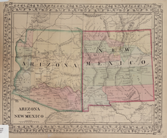
Map of Arizona and New Mexico, 1867

Date

1867

Description

26 x 32 cm. Relief shown by hachures. "Entered according to act of Congress in the year 1867 by S. Augustus Mitchell in the Clerks Office of the District Court for the Eastern District of Pennsylvania." Includes decorative border of grape vines. Shows Tucson as capital of Arizona; shows various trails including Cook's Wagon Route, Marcy's Route, and Kearney's Route. Written in pencil in lower right corner: 135. Original publisher: S.A. Mitchell.

Image

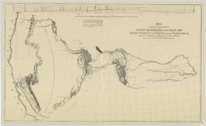
Map of an exploring expedition to the Rocky Mountains in the year 1842 and to Oregon & north California in the years 1843-44

Date

1845

Description

Scale 1:3,000,000. 47.35 miles to 1 in. (W 124°--W 94°/N 46°-- N 34°) ; 1 map ; 76 x 128 cm. ; Relief shown by hachures ; State 3: Includes notes, Great Basin statement, and place name South Park below Bayou Salade; some place names differ from other states ; Includes "Profile of the route from the mouth of the Kansas to the Pacific by Capt. J.C. Fremont in 1843." ; U.S. Senate

Image

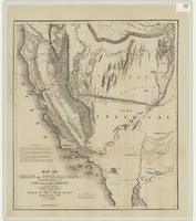
Map of Oregon and upper California from the surveys of John Charles Frémont and other authorities, 1848

Date

1848

Description

'Drawn by Charles Preuss under the order of the Senate of the United States, Washington City, 1848.' 'Lithy. by E. Weber & Co., Balto.' Relief shown by hachures and spot heights. Shows area of U.S. west of the Continental Divide. Includes explanatory notes and shows Frémont's exploring routes in 1842, 1844 and 1846. Scale 1:3,000,000 (W 124°--W 112°/N 42°--N 32°).

Image

Map of economical features of parts of southern Colorado and northern New Mexico, January 8, 1878

Date

1878-01-08

Description

37 x 49 cm. Relief shown by hachures and spot heights. "Atlas sheet no. 69(B)." "Issued Jan'y 8th 1878." "Expeditions of 1874-1875 & 1877 under the command of 1st. Lieut. Geo. M. Wheeler, Corps of Engineers, U.S. Army." Prime meridians: Greenwich and Washington, D.C. "Weyss, Lang & Herman, del." "By order of the honorable the Secretary of War." "Under the direction of Brig. General A. A. Hunphreys, Chief of Engineers, U. S. Army." Original publisher: U.S. Geographical Surveys West of the 100th Meridian, Scale: 1 inch to 4 miles or 1: 253440.

Image

Map of Mexico and Central America, 1842

Date

1842

Description

'Dresseé par M. Lapie, Colonel d'Etat Major. Et M. Lapie fils Capitaine au même Corp. Paris, 1842. Chez P.C. Lehuby Libre. Rue de Seine No. 53.' Scale [ca. 1:9,504,000. 1 in. to approx. 15 miles]. Relief shown by hachures. Prime meridian: Paris. Hand colored. 'Atlas universel 44e'--Upper margin. Probably from P. Lapie and A.É. Lapie's Atlas universel de géographie ancienne et moderne. Inset map: Carte du Guatemala ou provinces-unies de L'Amérique Centrale. P.C. Lehuby

Image