Search Results
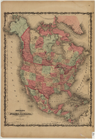
Map of North America, circa 1863
Date
1861 to 1865
Description
Scale [ca. 1:15,840,000. 1 inch to approx. 250 miles] (W 167°- -W27°/N 85°--N 10°) ; 1 map : hand col. ; 53 x 40 cm ; Hand colored ; Prime meridians: Greenwich and Washington, D.C. ; Includes mail routes and proposed railroad routes; Has decorative border ; Plates 15 and 16 from Johnson's new illustrated family atlas of the world ; Partial geographical index on verso ; Alternate title: North America Johnson and Ward
Text

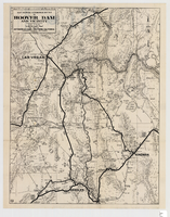
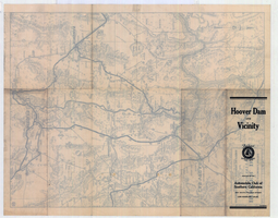
Map showing automobile routes to Hoover Dam and vicinity, circa 1934
Date
1930 to 1938
Description
'Prepared by the Automobile Club of Southern California.' 'burke' in lower right corner. '1352' in circle in lower left corner. Relief shown by hachures and spot heights. Shows mines, ranches, and springs. Scale [ca. 1:443,520] (W 115°30--W 114°--N 36°30/N 35°)
Image