Search Results
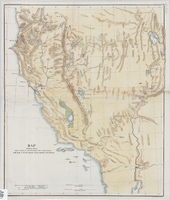
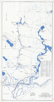
Map showing the different routes travelled over by the detachments of the Overland Command in the spring of 1855 from Salt Lake City, Utah, to the Bay of San Francisco, 1855
Date
1855
Description
57 x 47 cm. Indicates routes of Capt. Ingalls, Col. Steptoe, and Lt. Mowrey, and camping grounds. "Ackerman Lith. 319 Broadway, N.Y." Relief shown by hachures. In Wheat, "Mapping of the Trans-Mississippi West", v. 4, p. 210. Library's copy 1 is poor quality and not in color. Original publisher unknown, Series: Senate Ex. Doc. No. 1, 1st session, 34th Congress.
Image
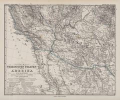
Die Vereinigten Staaten von Amerika in 6 Blättern im Maassstabe von 1:3,700,000
Date
1882
Description
33 x 41 cm. Relief shown by hachures and spot heights. Prime meridian: Greenwich. Sheet 4 of a 6-sheet map. "Petermann: ver. st. v. am. bi. 4". "Stieler's Hand Atlas, No. 86." Binder's title of Hand Atlas über alle Thiele der Erde und über das Weltgebäude, which was published in 1879. In German. Library has only map of Arizona and parts of surrounding states and northern Mexico. Original publisher: Justus Perthes.
Image
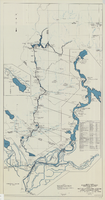
Map and operational diagram, lower Colorado River, Lees Ferry to Gulf of California, May 1957
Date
1957-05
Description
83 x 43 cm. "Drawing no. 423-300-59." "May 1957." "Supercedes 423-306-183." "Map compiled from Coast and Geodetic Survey sectional aeronautical charts, and Bureau of Reclamation data." Includes index to gaging stations. Shows dams, canals, levees, pumping plants, etc. Insets: [Salton Sea]--Operational diagram, no scale. "Revised June 1967." Original publisher: Bureau of Reclamation, Region 3.
Image
Map and operational diagram, lower Colorado River, Lees Ferry to Gulf of California, June 1973
Date
1973-06
Description
84 x 43 cm. "Map no. 423-300-59." Insets: [Salton Sea]--Operational diagram, no scale. Includes index to gaging stations. Shows dams, canals, levees, pumping plants, etc. "Map compiled from Coast and Geodetic Survey sectional aeronautical charts, and Bureau of Reclamation data." Original publisher: U.S. Dept. of the Interior, Bureau of Reclamation.
Image