Search Results
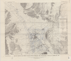
Map of part of Las Vegas Valley, Nevada, showing the piezometric surface in February 1955
Date
Description
Relief shown by contours. Includes township and range lines. Scale 1:96,000 (W 115°30´--W 114°45´/N 36°30´--N 36°00´). Series: Water-supply paper (Washington, D.C.)
1780. Originally published as plate 3 of Available water supply of the Las Vegas ground-water basin, Nevada, by Glenn T. Malmberg, published by the Geological Survey in 1965 as its Water-supply paper 1780.
Image
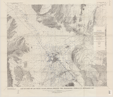
Map of part of Las Vegas Valley, Nevada, showing the piezometric surface in September 1955
Date
Description
Relief shown by contours. Includes township and range lines. Scale 1:96,000 (W 115°30´--W 114°45´/N 36°30´--N 36°00´). Series: Water-supply paper (Washington, D.C.)
1780. Originally published as plate 4 of Available water supply of the Las Vegas ground-water basin, Nevada, by Glenn T. Malmberg, published by the Geological Survey in 1965 as its Water-supply paper 1780.
Image
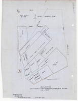
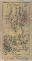
Plat showing cultivated land in the Stewart Ranch, Las Vegas, Nevada, December 8, 1902
Date
Archival Collection
Description
Image
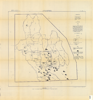
Map of part of Las Vegas Valley, Nevada, showing the approximate piezometric surface in 1912
Date
Description
Image
Map showing chemical diagrams representing quality of water in Clark and Nye counties, Nevada, 1963
Date
Description
Image

Plan of proposed new well pipe and fittings for Las Vegas, Nevada, 1936
Date
Archival Collection
Description
Image
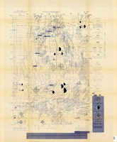
Map of a part of southern Nevada showing ground-water conditions, 1914
Date
Description
Image
Map of the Nevada Test Site and vicinity showing principal rock types and chemistry of ground water, 1964
Date
Description
Image
Map showing possible industrial users' connections to railroad pipelines in Las Vegas Nevada, circa 1930-1931
Date
Archival Collection
Description
Map showing industrial users' connections to railroad pipelines in Las Vegas, Nevada.
Image

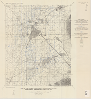
Topographic map of the Las Vegas Valley and surrounding northern and western mountain ranges, 1943
Date
Description
Text