Search Results

General highway base map, state of Nevada, 1975
Date
1975
Description
'Prepared by Nevada State Highway Department, Planning Survey Division, in cooperation with U.S. Department of Transportation, Federal Highway Administration.' 'Copyright Nevada State Highway Department.' 'Transverse mercator projection. Mount Diablo base and meridian. 50,000 meter universal transverse mercator grid zone 11.' Insets of Reno-Sparks area, Las Vegas area, Lake Tahoe area. 29-H53/21:N41-1975.
Image
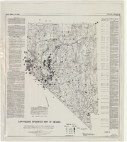
Earthquake epicenter map of Nevada, December 1964
Date
1964-12
Description
Scale 1:1,000,000 (W 120°--W 114°/N 42°--N 35°). Title in upper right margin: Earthquake epicenter map ; "Nevada earthquake epicenters for the period from about 1852 to 1961 are plotted on the accompanying map." ; "Contour interval 1,000 feet." ; "Supported by grant no. AF-AFOSR-62-285 of the Air Force of Scientific Research." ; "December 1964." ; "Base from NBM Map 17." ; "One million scale set." ; Includes bibliographical references ; Includes text and index. Nevada Bureau of Mines, University of Nevada
Text
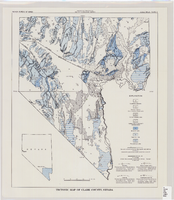
Tectonic map of Clark County, Nevada, 1965
Date
1965
Description
'Nevada Bureau of Mines. Bulletin 62, plate 5.' 'Prepared cooperatively by the U.S. Geological Survey.' Shows types of rocks as well as faults. Scale [ca. 1:760,320. 1 in. to approx. 12 miles] (W 116°--W 114°/N 37°--N 35°). Bulletin (Nevada Bureau of Mines)62.
Image
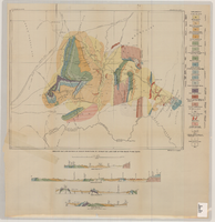
Geologic map and sections of Muddy Mountains, St. Thomas Gap, and part of the Grand Wash Cliffs, 1928
Date
1928
Description
'Geology by C.R. Longwell.' At top of map: 'U.S. Geological Survey Bulletin 798, plate 1.' Includes four colored cross-sections. 1:250,000 (W 115°00'--W 113°45'/N 36°45'--N 36°00'). Series: Bulletin (Geological Survey (U.S.)no. 798. Originally published as plate 1 in: Geology of the Muddy Mountains, Nevada, with a sections through the Virgin Range to the Grand Wash Cliffs, Arizona / by Chester R. Longwell. Washington, D.C. : Government Printing Office, 1928. (Bulletin ((Geological Survey (U.S.)), no. 798).
Image
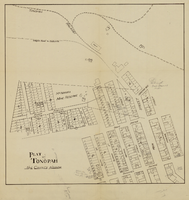
Plat of Tonopah, Nye County, Nevada, circa 1905
Date
1903 to 1907
Description
Plat of properties in downtown Tonopah, Nevada. Notes handwritten in pencil. Southern Nevada Mining Map Collection
Image

Map of Las Vegas Valley artesian basin, circa 1940
Date
1938 to 1942
Description
Scale [ca. 1:72,000. 1 in.=approx. 6,000 feet] (W 115°10´--W 115°/N 36°20´--N 36´). Shows wells, springs, boundary between valley fill and bedrock, and ground water district boundaries for Las Vegas Metropolitan Area and North Las Vegas. "Figure 1." Nevada. State Engineer
Image
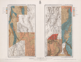
Maps of geographical surveys of parts of California, southeastern Nevada, Arizona and southwestern Utah, made under the command of George M. Wheeler, 1872-1873
Date
1872 to 1873
Description
At top of plate: 'U.S. geographical surveys west of the one-hundredth meridian. Parts of California, S.E. Nevada, Arizona & S.W. Utah.' At bottom of plate: 'Expeditions of 1872 & 1873, under the command of 1st Lieut. Geo. M. Wheeler, Corps of Engineers, U.S. Army.' 'G. K. Gilbert, A. R. Marvine, E. E. Howell, geological assistants.' 'By order of The Honorable The Secretary of War, under the direction of Brig. Gen. A. A. Humphries, Chief of Engineers, U.S. Army.' Published by Government Printing Office. 2 map sections on 1 sheet. Scale: 1 inch to 8 miles.
Image
Geologic map of the Atomic Energy Commission Nevada Proving Grounds Area, Nye and Clark Counties, Nevada, 1952
Date
1952
Description
'At top of map: ' United States Department of the Interior. Geological Survey.' ' Bulletin 1021, Plate 32.' At bottom of map: 'Geology by Donald E. Hibbard and Mike S. Johnson, 1952.' 'Base from USAF Aeronautical Chart and Information Service, April 1952.' 'Interior--Geological Survey, Washington, D.C. MR-3767.' Scale 1:63,360 (W 116°10--W 115°55/N 37°15--N 36°40)
Geological Survey bulletin, 1021
Image

Topographic map of the Las Vegas Valley area, 1959
Date
1959
Description
Scale 1:250,000 ; Transverse Mercator proj. (W 116°--W 114°/N 37°--N 36°) ; 1 map : col. ; 45 x 72 cm ; Relief shown by contours and spot heights. Contour interval 200 feet ; Margin title ; "Compiled in 1955 by photogrammetric methods by U.S. Coast and Geodetic Survey and from Nevada 1:48,000 and 1:62,500, USGS, 1952-54, and Nevada 1:50,000, CE, 1952. Planimetric detail revised by photo-planimetric methods. Horizontal and vertical control by USGS, USC& GS, and CE. Photography field annotated 1954. Road data 1954." ; Shows townships and ranges ; Gives 1955 declination from true north ; Includes location diagram, reliability diagram, and sectionalized township map ; Filing title: Las Vegas, Nevada; Arizona; California ; Interior--Geological Survey
Image
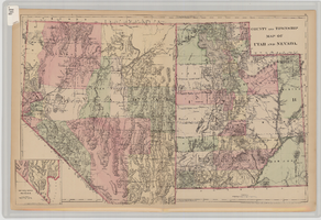
County and township map of Utah and Nevada, 1881
Date
1881
Description
'Entered according to Act of Congress in the year 1881 by S. Augustus Mitchell in the Office of the Librarian of Congress at Washington.' Relief shown by hachures. Prime meridians: Greenwich and Washington. In upper-right corner: 91. Shows range and township grid. Includes inset of southern portion of Nevada Scale [ca. 1:1,750,000]. 1 in. to approx. 27 miles (W 120°--W 109°/N 42°--N 35°).
Image