Search Results
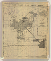
Map of Las Vegas Valley, Clark County, Nevada, circa 1950-1956
Date
1950 to 1956
Description
'Nevada Title Insurance Co. Compiled by Tyson Engineering Co. ... Las Vegas, Nevada. Drawn by A.A. Elliott, Jr.' Shows sewer, water, gas and power lines, water treatment facilities, steam plants, boundaries of the Las Vegas Valley Water District and the Clark County Sanitation District boundaries. Scale [ca. 1:63,360. 1 in. to approx. 1 mile].
Image
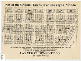
Plat of the original townsite of Las Vegas, Nevada, circa 1905
Date
1901 to 1910
Description
'Las Vegas is the main division headquarters of San Pedro, Los Angeles & Salt Lake Ry. The gateway to Nevada's richest mining section. 336 miles from Los Angeles. 444 miles from Salt Lake City.' Second copy available in the J.T. McWilliams manuscript collection.
Image
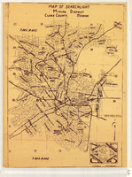
Map of Searchlight mining district, Clark County, Nevada, circa 1905
Date
1901 to 1909
Description
At bottom right of map: 'C.D. Baker, A.R. Thompson.' Title in lower right corner: 'Map of Searchlight mining district: mineral patents, water rights.' Logo of Nevada Engineering Construction Service, Inc., Las Vegas, Nev. in lower right corner. Blueline print. Shows mineral patents and water rights. Nevada Engineering & Construction Service, Inc.
Image

Map of metropolitan Las Vegas, Nevada area, circa 1957
Date
1955 to 1960
Description
Compiled and drawn by California State Automobile Association.--Panel ; "California State Automobile Association. Nevada Division." ; Includes indexes ; Includes inset maps of Nellis Air Force Base and area bounded on the north by Cheyenne Ave. and by Charleston Blvd. on the south. Signature of Elton M. Garrett of back of map. California State Automobile Association.
Text
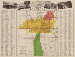
General map of Las Vegas, Nevada, circa 1957
Date
1955 to 1959
Description
'Compiled and issued by the Campbell Realty Company.' At top pf map: ' Greater Las Vegas.' Shows names of housing tracts and locations of hotels and motels on the Las Vegas Strip. Includes indexes and photographs of local recreation and attractions. Originally published by Campbell Realtydistributed by Las Vegas Nevada Chamber of Commerce . Scale (ca. 1:39,000. 1 in. to approx. 3,250 ft.].
Text
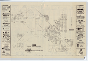
Street map of Henderson, Nevada, 1982
Date
1982
Description
53 x 68 cm. "Industrial center of Nevada, gateway to Lake Mead." Includes advertisements. Index, advertisements, and inset map of Las Vegas area on verso. "Copyright 1981." Original publisher: Chamber of Commerce (Henderson, Nev.). Original publisher: Chamber of Commerce (Henderson, Nev.)
Image
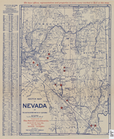
Sketch map of Nevada and the southeastern portion of California, 1906
Date
1906
Description
42 x 29 cm. Relief shown by hachures. Copyright held by George S. Clason. "Compliments of the Patrick Investment Co. ... Denver, Colorado." Includes index. Shows railroad routes. "We have offices, representatives and properties in every camp marked in red on this map." Original publisher: Clason Map Co..
Image
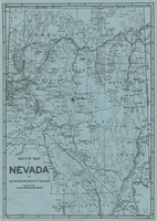
Sketch map of Nevada and the southeastern portion of California, 1906
Date
1906
Description
34 x 24 cm. Relief shown by hachures. Map may be a reprint of a map by George S. Clason, published by the Clason Map Co. in Denver, Colo., in 1906. Map is printed on blue paper. "OPHIR" and a star printed near Pueblo in Nye County. Shows railroad routes.
Image
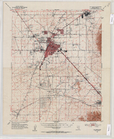
Topographic map of the Las Vegas Valley Area, 1952
Date
1952
Description
Scale 1:62,500 ; polyconic proj ; 1 map : col. ; 45 x 36 cm.; Relief shown by contours and spot heights. Contour interval 20 ft. ; Includes quadrangle location map ; Nevada 15 minute series (topographic) ; Fifteen minute series (topographic) Nevada ; Geological Survey
Image
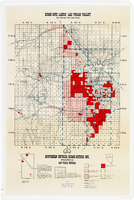
Map showing home-site lands in the Las Vegas Valley, 1955
Date
1955
Description
Scale [1:84,269. 1 in. to 1 1/3 miles] ; 1 map : col. ; 57 x 50 cm. on sheet 89 x 59 cm ; Cadastral map ; Gives definition of township, section and acre ; Relief shown by form lines and spot heights ; Shows private land, land classified for small tracts, leased land, vacant Federal land, section numbers, number of acres in each homesite and purchase price of tract ; "From your Congressman Cliff Young."--stamped on map ; Southern Nevada Home-Siters
Image