Search Results

Las Vegas Valley map, Clark County, Nevada, June 1958
Date
1958
Description
'Compiled 1954. First revision - June 1958.' 'Area extends 9 miles north, 11 miles south, and 3 miles east, 3 miles west city limits of Las Vegas.' Original publisher: Campbell Realty. Scale [ca. 1:60,000. 1 in. to approx. 5,000 ft.]. Cadastral map. Hand-drawn red line around some sections on map.
Image

Map showing proposed annexation of Las Vegas Valley, Clark County, Nevada, January 1, 1929
Date
1929-01-01
Description
'Compiled by C. D. Baker, C.E., United States Mineral Surveyor, State Right Water Surveyor, Nevada. Las Vegas, Nev. January 1, 1929. Copyright applied for.' ; "Filed Dec. 10, 1936" and signed by Viola Burns, clerk, city of Las Vegas ; Hand-printed title at top of map: Proposed annexation to Las Vegas ; Map is stamped as Filed Dec 10, 1936 and signed by Las Vegas City Clerk Viola Burns. Library's copy has brown line hand-drawn around area to be annexed.
Image
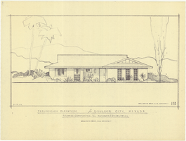
Architectural drawing of residential home in Boulder City, Nevada, preliminary elevation, September 19, 1962
Date
1962-09-19
Archival Collection
Description
Preliminary drawing of front exterior elevation of a ranch-style residential home in Boulder City, Nevada.
Architecture Period: Mid-Century ModernistImage

Topographic map of Nevada-California, Las Vegas quadrangle, 1951
Date
1951
Description
'Edition of Mar. 1908, reprinted 1951.' 'E.M. Douglas, geographer in charge; Topography and triangulation by R.H. Chapman, B.D. Stewart, J.E. Blackburn, and D.F.C. Moor. Surveyed in 1906-1907.' Scale 1:250,000 ; polyconic proj. (W 116°00--W 115°00/N 37°00--N 36°00). Relief shown by contours and spot heights. Title in lower-right corner: Nev.-Calif., Las Vegas. Contour interval 100 feet. Datum is mean sea level. U.S. Geological Survey
Image

Map showing location of the Las Vegas & Tonopah Railroad from Las Vegas to Bullfrog, Nevada, 1906
Date
1906
Archival Collection
Description
'Office of Chief Engineer' printed on map above date.
Image
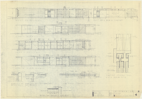
Architectural drawings of a residential home in Las Vegas, Nevada, November 2, 1962
Date
1963-11-02
Description
Exterior elevations and details for a residential home on Fifth Place in Las Vegas, Nevada. Sheet no. 4. "Drw. D.H."
Architecture Period: Mid-Century ModernistImage

Topographic map of the northeast quadrangle of the metropolitan Las Vegas, Nevada area, 1967
Date
1967
Description
Scale 1:24,000 ; polyconic proj. (W 115°730--W 115°0000/N 36°1500--N 36°730) ; 1 map : col. ; 58 x 47 cm ; 7.5 minute series (topographic) ; Relief shown by contours and spot heights ; Filing title: Las Vegas NE, Nev ; "AMS 2956 II NE--Series V896." ; Contour interval 20 feet ; "Topography by photogrammetric methods from aerial photographs taken 1965. Field checked 1967." ;Includes quadrangle location map ; Interior--Geological Survey
Image

Topographic map of the northeast quadrangle of the metropolitan Las Vegas, Nevada area, 1973
Date
1973
Description
Scale 1:24,000 ; polyconic proj. (W 115°730--W 115°0000/N 36°1500--N 36°730) ; 1 map : col. ; 58 x 47 cm ; 7.5 minute series (topographic) ; Relief shown by contours and spot heights ; "AMS 2956 II NE--Series V896." ; Contour interval 20 feet ; "Topography by photogrammetric methods from aerial photographs taken 1965. Field checked 1967." ; "Revisions shown in purple compiled from aerial photographs taken 1973. This information not field checked." ; Includes quadrangle location map ; Filing title: Las Vegas, NE, Nev ; Interior--Geological Survey
Image

Topographic map of the northwest quadrangle of the metropolitan Las Vegas, Nevada area, 1967
Date
1967
Description
Scale 1:24,000 ; polyconic proj. (W 115°1500--W 115°730/N 36°1500--N 36°730) ; 1 map : col. ; 58 x 47 cm ; 7.5 minute series (topographic) ; Relief shown by contours and spot heights ; Filing title: Las Vegas NW, Nev ; "AMS 2956 II NW--Series V896." ; Contour interval 10 feet ; "Topography by photogrammetric methods from aerial photographs taken 1965. Field checked 1967." ; Includes quadrangle location map ; Interior--Geological Survey
Image

Topographic map of the northwest quadrangle of the metropolitan Las Vegas, Nevada area, 1973
Date
1973
Description
Scale 1:24,000 ; polyconic proj. (W 115°1500--W 115°730/N 36°1500--N 36°730) ; 1 map : col. ; 58 x 47 cm ; 7.5 minute series (topographic) ; Relief shown by contours and spot heights ; Filing title: Las Vegas NM, Nev ; "AMS 2956 II NW--Series V896." ; Contour interval 10 feet ; "Topography by photogrammetric methods from aerial photographs taken 1965. Field checked 1967." ; "Revisions shown in purple compiled from aerial photographs taken 1973. This information not field checked." ; Includes quadrangle location map ; Interior--Geological Survey
Image