Search Results
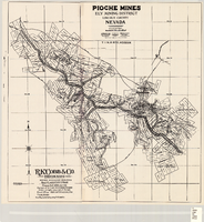
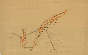
Map of Pioche mines, Ely Mining District, Lincoln County, Nevada, 1909
Date
1909
Description
'A.D. Knowlton, Mining Engineer, Pioche, Nevada; H.H. Snelgrove, Draftsman, Salt Lake City, Utah. Copyright 1909 Rufus K. Cobb.' Includes township and range grid; Includes wagon roads. Published by R.K. Cobb. Photocopy.
Image
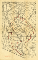
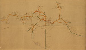
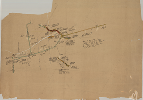
Map of mines owned and operated by Goldfield Deep Mines Company of Nevada, circa 1904-1908
Date
1904 to 1908
Description
Printed on map: 'Boundary in red.'
Image
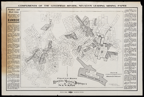
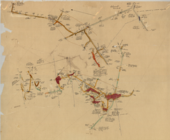
Map of Rawhide Mining District, Nevada, circa 1908
Date
1905 to 1911
Description
'Numbers and black lines show locations of the principal mines, prospects and leases of Rawhide.' 'Compiled by Engraving Department of the Goldfield Review. Olmstead and Rich, Mining Engineers, Goldfield, Nevada.' At top of map: 'Compliments of the Goldfield Review, Nevada's leading mining paper.' Includes index. Published by Goldfield Review Press.
Text

Tonopah, Nevada mining map, March 1904
Date
1904-03
Description
'U.S. Geological Survey, George Otis Smith, Director.' 'R.U. Goode, Geographer in charge. Triangulation by U.S. Coast and Geodetic Survey. Topography by W.J. Peters. Surveyed in 1902-1903.' 'Edition of Mar. 1904, reprinted Apr. 1910.' Oriented with north toward the upper left. Relief shown by contours and hachures. Scale 1:12,000 (W 117°14´--W 117°12´/N 38°05´--N 38°03´)
Text
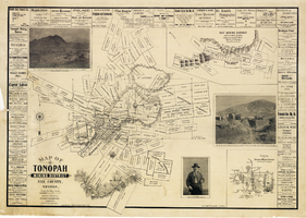
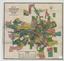
Map of Tonopah Mining District, Nye County, Nevada, 1902
Date
1902
Description
'Compiled and published by Booker & Bradford, engineers, Tonopah, Nevada.' 'Copyrighted by Booker & Bradford 1902.' 'Lith. Britton & Rey, S.F., Cal.' Relief shown by hachures. Includes insets of Ray Mining District, Nye County, Nevada, and Vicinity map of Tonopah Mining District, Nye County, Nevada. Includes advertisements and photographs of Tonopah ore, town of Tonopah, and of J.L. Butler, discoverer of the Mizpah Lode. Scale [ca. 1:7,200]. 1 inch to 600 feet. Mounted on linen.
Text
Map of the 450 foot level of the Mohawk Mine, Goldfield, Nevada, circa 1902-1908
Date
1902 to 1908
Description
'(3rd) 450 Ft. level Mohawk.' Hand-drawn, hand-colored and annotated map showing the 450 foot, or third, level of the Mohawk Mine.
Image
Map of Tonopah Mining District, Nevada, 1905
Date
1905
Description
In lower right corner: 'Copyrighed by Bradford & Bradford 1905.' Includes table of distances from Tonopah. Relief shown by hachures. Scale [ca. 1:15,600. 1 in. to approx. 1300 feet]. Library's copy has one section outlined in red pencil and 'Tonopah Victor' hand-printed on it in red pencil. Red pencil dots are on two other sections. '1905' and some illegible words written in pencil near title of map.
Image
Map of the 600 foot, or third, level of the Clermont Mine, Goldfield, Nevada, circa 1902-1908
Date
1902 to 1908
Description
Hand-drawn, hand-colored and annotated map showing the 600 foot, or third, level of the Clermont Mine. Handwritten at top of map: 'Clermont, 3rd level.'
Image
Map of the 130 foot level of the Combination Mine, Goldfield, Nevada, circa 1902-1908
Date
1902 to 1908
Description
'130 ft. level. Combination Mine.' 'Scale 1 in.=40 ft.' Hand-drawn, hand-colored and annotated map showing the 130 foot level of the Combination Mine.
Image
Map of the eighth level of the Clermont Mine, Goldfield, Nevada, circa 1902-1908
Date
1902 to 1908
Description
Hand-drawn, hand-colored and annotated map showing the eighth level of the Clermont Mine.
Image