Search Results

Map showing U.S. Bureau of Reclamation Region 3 projects in Arizona, California, Nevada, New Mexico and Utah, September 1967
Date
1967-09
Description
'United States, Department of the Interior, Stewart L. Udall, Secretary. Bureau of Reclamation, Floyd E. Dominy, Commissioner.' 'Map. No. X-300-738. September 1967.' Scale [ca. 1:1,774,080] (W 119°--W 108°/N 39°--N 32°). Relief shown pictorially. Shows completed, under construction and proposed dams and reservoirs, canals, and aqueducts, power plants, pumping plants, substations, transmission lines, tunnels and siphons. Also shows non-Bureau of Reclamation dams, reservoirs, tunnels, pipelines and irrigated lands. Includes inset map of location of Region 3 and key map of drainage basins. Bureau of Reclamation, [Region 3?].
Image
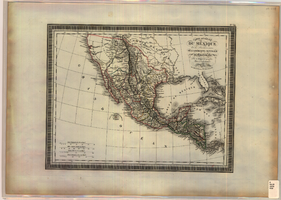
Map of Mexico and Central America, 1826
Date
1826
Description
'Par L. Vivien, Géographe, Gravée par Giraldon-Bovinet. 1826, Paris. Chez Ménard & Desenne, Rue Git-le-Coeur, No. 8.' Scale [ca. 1:15,840,000] (W 125°--W 75°/N 35°--N 05°). Relief shown by hachures. Hand colored. Atlas plate number in upper margin: no. 34. Ménard & Desenne
Image
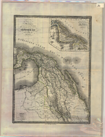
Map of Mexico and Central America, 1842
Date
1842
Description
'Dresseé par M. Lapie, Colonel d'Etat Major. Et M. Lapie fils Capitaine au même Corp. Paris, 1842. Chez P.C. Lehuby Libre. Rue de Seine No. 53.' Scale [ca. 1:9,504,000. 1 in. to approx. 15 miles]. Relief shown by hachures. Prime meridian: Paris. Hand colored. 'Atlas universel 44e'--Upper margin. Probably from P. Lapie and A.É. Lapie's Atlas universel de géographie ancienne et moderne. Inset map: Carte du Guatemala ou provinces-unies de L'Amérique Centrale. P.C. Lehuby
Image
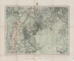
Map of economic features, part of central New Mexico, May 7, 1877
Date
1877-05-07
Description
37 x 50 cm. Relief shown by hachures and spot heights "Atlas sheet no. 77(B)." "Issued May 7th 1877." "Expeditions of 1871 & 1786 under the command of 1st. Lieut. Geo. M. Wheeler, Corps of Engineers, U.S. Army." "Weyss, Herman & Lang, del." "By order of the honorable the Secretary of War." "Under the direction of Brig. General A. A. Hunphreys, Chief of Engineers, U. S. Army." "2nd. Ed. June 30th, 1881." Original publisher: U.S. Geographical Surveys West of the 100th Meridian, Scale: 1 inch to 4 miles or 1: 253440.
Image
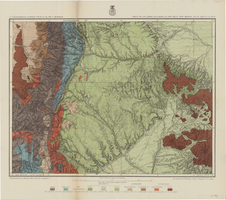
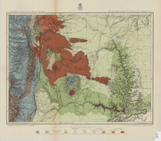
Map of parts of southern Colorado and northern New Mexico, atlas sheet no. 70(A), 1877
Date
1877-05-07
Description
37 x 50 cm. Prime meridian: Washington, D.C. Relief shown by hachures and spot heights. "Issued May 7th, 1877. 2nd ed., June 30th, 1881." "Atlas sheet no. 77(B)." "Expeditions of 1871 & 1786 under the command of 1st. Lieut. Geo. M. Wheeler, Corps of Engineers, U.S. Army." "Weyss, Herman & Lang, del." Probably originally published as part of the geological atlas which is an appendix to the Surveys' Report upon United States geographical surveys west of the one hundredth meridian. Geological map. "Prof. John J. Stevenson, geological assistant." Original publisher: U.S. Geographical Surveys West of the 100th Meridian, Scale: 1 inch to 4 miles or 1: 253440.
Image
Map of part of north central New Mexico, atlas sheet no. 70(C), May 7th, 1877
Date
1877-05-07
Description
39 x 50 cm. Relief shown by hachures and spot heights. "Issued May 7th 1877-2nd ed. June 30th, 1881." "Expeditions of 1878 and 1879 under the command of 1st. Lieut. Geo. M. Wheeler, Corp. of Engineers U.S. Army." "Weyss Herman & Lang Del." Prime meridians: Washington, D.C. and Greenwich Geological map Probably originally published as part of the geological atlas which is an appendix to the Surveys' Report upon United States geographical surveys west of the one hundredth meridian. "Prof. John J. Stevenson, geological assistant." "By order of the honorable the Secretary of War under the direction of Brig. General A. A. Hunphreys, Chief of Engineers, U. S. Army." Original publisher: U.S. Geographical Surveys West of the 100th Meridian, Scale: 1 inch to 4 miles or 1: 253440.
Image