Search Results
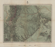
Map of part of North Central New Mexico atlas sheets 69(B), 69(D), 77(B) and 78(A), June 30, 1881
Date
1881-06-30
Description
39 x 52 cm. Relief shown by hachures and spot heights "Issued June 30, 1881." "Expeditions of 1873, 1878 and 1879 under the command of 1st. Lieut. Geo. M. Wheeler, Corps of Engineers U.S. Army." Geological map Probably originally published as part of the geological atlas which is an appendix to the Surveys' Report upon United States geographical surveys west of the one hundredth meridian. "Prof. John J. Stevenson, geological assistant." "By order of the honorable the Secretary of War under the direction of Brig. General A. A. Hunphreys, Chief of Engineers, U. S. Army." Original publisher: U.S. Geographical Surveys West of the 100th Meridian, Scale: 1 inch to 4 miles or 1: 253440.
Image
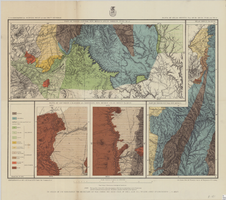
Map of economic features of parts of southern Colorado and northern New Mexico Atlas sheet no. 70(A.), May 5, 1877
Date
1877-05-07
Description
37 x 49 cm. Relief shown by hachures and spot heights. Prime meridians: Greenwich and Washington, D.C. "Atlas sheet no. 70(A)." "Issued May 7th, 1877." "Expeditions of 1874, 1875 & 1876 under the command of 1st. Lieut. Geo. M. Wheeler, Corps of Engineer, U.S. Army." "Weyss, Herman & Mahlo, del." "By order of the honorable the Secretary of War." "Under the direction of Brig. General A. A. Hunphreys, Chief of Engineers, U. S. Army." Original publisher: U.S. Geographical Surveys West of the 100th Meridian, Scale: 1 inch to 4 miles or 1: 253440.
Image