Skip to main content
Main navigation
Finding Aids
Digital Projects
African American Experience in Las Vegas
Charles Saladino Landscape Architecture Collection
Culinary Union Photograph Collection
Dino at the Sands
Dreaming the Skyline
Entertainment
Historic Landscape of Nevada
Hoover Dam
Jamey Stillings
Menus: The Art of Dining
Nevada Test Site Oral History Project
Newspapers
Oral Histories Collection
Photograph Collections
Rebel Yell Newspaper
Showgirls
Southern Nevada: The Boomtown Years 1900-1925
Southern Nevada History in Maps
Southern Nevada Jewish Heritage Project
UNLV CSUN Records
Union Pacific Railroad Water Documents
Walking Box Ranch Collection
Welcome Home Howard
About
Request Images
Help
Provide Feedback
Special Collections Home
Search the Special Collections and Archives Portal
Search
Search
Breadcrumb
Special Collections and Archives Portal
Search Results
Display
List
Grid
Results Per Page
10
25
50
100
250
mexico
Southern Nevada and Las Vegas, History in Maps
Displaying results 41 - 50 of 54
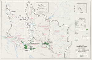
Map of Region 3 projects, Arizona-California-Nevada-New Mexico-Utah, September 1967
Image
View
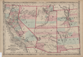
Map of California, territories of New Mexico, Arizona, Colorado, Nevada and Utah, circa 1863, page 1
View
Map of California, territories of New Mexico, Arizona, Colorado, Nevada and Utah, circa 1863, page 2
View
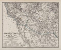
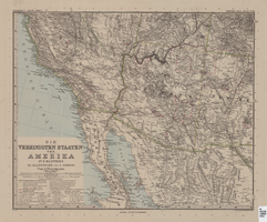
Die Vereinigten Staaten von Amerika in 6 Blättern im Maassstabe von 1:3,700,000
Image
View
Map of Southwestern United States of America, 1888
Image
View
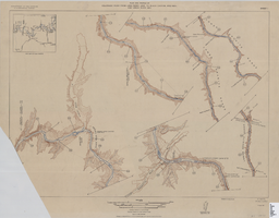
Map of plan and profile of Colorado River from Lees Ferry, Arizona to Black Canyon, Arizona-Nevada and Virgin River, Nevada, 1924
Image
View
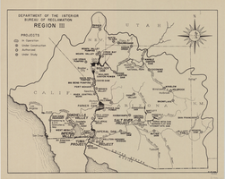
Map of Bureau of Reclamation Region III, August 1, 1945
Image
View
Regional map showing main air, highway, bus and railroad transportation, October 30, 1945
Image
View
Map and operational diagram, lower Colorado River, Lees Ferry to Gulf of California, May 1957
Image
View
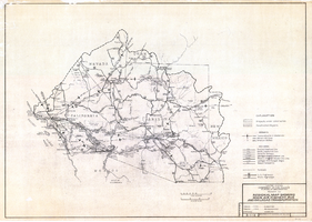
Topographic map of the Boulder Canyon Reservoir site, 1930
Image
View
Pagination
First page
« First
Previous page
‹ Previous
Page
1
Page
2
Page
3
Page
4
Current page
5
Page
6
Next page
Next ›
Last page
Last »
Go
Refine my results
Content Type
Digital Object (54)
Creator or Contributor
Johnson, A. J. (Alvin Jewett), 1827-1884 (8)
Geographical Surveys West of the 100th Meridian (U.S.) (6)
J.H. Colton & Co. (3)
Johnson and Ward (3)
Justus Perthes (Firm : Gotha, Germany) (3)
Stevenson, John J. (John James), 1841-1924 (3)
Stieler, Adolf, 1775-1836 (3)
United States. Bureau of Reclamation (3)
United States. Bureau of Reclamation. Region 3 (3)
J. & C. Walker (Firm) (2)
John S. Cook & Company Bank (2)
Pellen, J. H. (John H.) (2)
Petermann, A. (August), 1822-1878 (2)
Society for the Diffusion of Useful Knowledge (Great Britain) (2)
United States. Army. Corps of Topographical Engineers (2)
Abert, John James, 1788-1863 (1)
Bien, Julius, 1826-1909 (1)
Cella Barr Associates (1)
Colton, J. H. (Joseph Hutchins), 1800-1893 (1)
G.W. & C.B. Colton & Co. (1)
Geological Survey (U.S.) (1)
Giraldon Bovinet (1)
Habenicht, Hermann, 1844-1917 (1)
Hall, Sidney (1)
Kern, M. H. (1)
Kern, Richard H., 1821-1853 (1)
Lapie, M. (Pierre), 1779-1850 (1)
Lehuby, P. C. (1)
Mitchell, S. Augustus (Samuel Augustus), 1792-1868 (1)
Parke, John G. (1)
Rapkin, J. (1)
Rogers, Henry D. (Henry Darwin), 1808-1866 (1)
Sitgreaves, Lorenzo, 1811-1888 (1)
Stülpnagel, F. von (1)
United States. Bureau of Land Management (1)
Vivien de Saint-Martin, M. (1)
Walker, John, 1786-1873 (1)
Wheeler, George M. (George Montague), 1842-1905 (1)
Subject
Southwest, New (22)
Arizona (8)
Colorado (8)
New Mexico (8)
Utah (8)
Mexico (7)
California (6)
Irrigation (6)
Reclamation of land (6)
Nevada (5)
Water resources development (5)
Central America (4)
Colorado River (Colo.-Mexico) (3)
Geology (3)
Land capability for agriculture (3)
North America--Colorado River Region (3)
North America--Colorado River Watershed (3)
Southwestern States (3)
Land use (2)
Mexico, North (2)
United States (2)
American Civil War (1861-1865) (1)
Boulder Canyon Project (U.S.) (1)
Colorado River Basin Project (U.S.) (1)
Discoveries in geography (1)
History (1)
Hydrology (1)
Indian country (United States law) (1)
Indians of North America (1)
Irrigation projects (1)
Military campaigns (1)
Military reconnaissance (1)
Texas (1)
Transportation (1)
West (U.S.) (1)
West Indies (1)
Zoning (1)
Archival Collection
Chester R. Longwell Professional Papers (1)
Digital Project
Culinary Workers Union Local 226 Photographs (167)
Nevada Test Site Oral History Project (71)
Southern Nevada and Las Vegas, History in Maps (54)
Entertainment (42)
African American Experience in Las Vegas (33)
UNLV CSUN Minutes (29)
Southern Nevada Jewish Heritage Project (27)
Menus: The Art of Dining (16)
Southern Nevada The Boomtown Years 1900-1925 (9)
The Historic Landscape of Nevada: Development, Water and Natural Environment (4)
Welcome Home, Howard (2)
Historic Landscape of Nevada (1)
Jamey Stillings Collection (1)
Resource Type
Still Image (43)
Text (3)
Year
We are sorry, but this facet only works with JavaScript enabled. Please check your browser's settings.
Material Type
maps (documents) (46)
Place
New Mexico (30)
Arizona (21)
Nevada (21)
California (20)
Utah (20)
Colorado (18)
Oregon (2)
Texas (2)
Clark County (1)
Mohave County (1)
Nebraska (1)
Language
English (25)