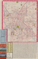
Search the Special Collections and Archives Portal

Search Results

Display    Results Per Page
Displaying results 121 - 130 of 581876

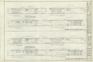
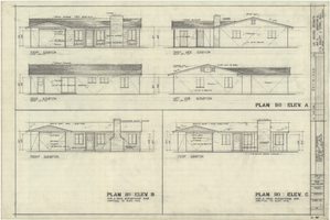
Architectural drawings of residential home in Las Vegas, Nevada, exterior elevations, 1955

Date

1955

Description

Front, rear, left and right exterior elevations of a ranch-style residential home in the Greater Las Vegas development in Las Vegas, Nevada.
Site Name: Greater Las Vegas

Architecture Period: Mid-Century Modernist

Image

Map showing profile of 24-inch cast iron water pipeline for Las Vegas, Nevada, May 20, 1930

Date

1930-05-20

Description

'As constructed. Drawing W.O. - 8577. Office of Chief Engineer, Los Angeles. Drawing No. 41092.' 'Scale for details 1"=10'. 5-20-1930. P.F.D.' 'Scale 1"=100'.' 'Profile of new 24" CI pipe. Scale 1"=600'. Ver. 1"=20'.' Blueprint. Map of the water pipes for Las Vegas. Includes the buildings in the railroad yard, a detailed map of a section of the pipe, a profile of the 24 inch C.I. pipe, and a map of the point of diversion. Date of detailed map is 5-20-1930. Library's copy has hand-written additions in color. Los Angeles & Salt Lake Railroad Co., Office of Chief Engineer,

Image

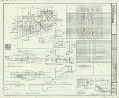
Architectural drawing of additions and alterations to the mens' and womens' health clubs in the Sands Hotel, Las Vegas, Nevada, April 19, 1965

Date

1965-02-25

Description

Floor plans, sections, elevations for mens' and womens' health clubs at the Sands Hotel, Las Vegas, Nevada. Includes door and finish schedules. "Sheet no. 17A. Job no. 420. Drawn by Shoji Yasuda. Job captain, Mas Tokubo. 2-26-65. Revised 4-19-65."
Site Name: Sands Hotel
Address: 3355 Las Vegas Boulevard South;

Latest Drawing Revision: 1965-04-19

Image

Map showing plan for water quality management update for wastewater collection systems in the Las Vegas Valley, February 20, 1997

Date

1997-02-20

Description

'Plate 1. Source: Clark County Geographic Information Systems Central Repository. Comprehensive Planning, Advanced Planning Division. Feburary 20, 1997.' Scale [ca. 1:95, 040. 1 in.=approx. 1.5 miles]. Shows sewers, force mains, service area boundaries, watershed boundaries, and lift stations. Includes inset location map. Includes township and range grid. Clark County, Nevada, Comprehensive Planning, Advanced Planning Division.

Image

Plan of proposed new well pipe and fittings for Las Vegas, Nevada, 1936

Date

1936

Description

Blueprint. Written on back of map:: 'Purposed [sic] new transmission lines--1936--transits.' Las Vegas Land and Water Company?

Image

Map of Boulder Dam area and Las Vegas, Nevada, October 7, 1930

Date

1930-10-07

Description

'F.V. Owen, publisher ... Los Angeles, California. Topography by C.H. Fenner, C.E. Decorations by L.J. Bergère. Gov't. data, H.A. Shamberger, C.E. Copyright, 1930, by F.V. Owen.' At bottom right of map: 'Dated Oct. 7th, 1930.' Relief shown by contours and spot heights. Contour lines are 100 feet. Incudes six hand-colored illustrations showing local points of interest. Includes information on Hoover Dam, and chart of mileages from Las Vegas. Scale [ca. 1:63,360]. 1 inch to 1 mile

Text

Plat of H.F.M & M addition to city of Las Vegas, Clark County, Nevada, comprising the west 1/2 of N.W. 1/4 Sec. 27, Twp. 20 S., R. 61 E., M.D.B & M, March 8, 1924

Date

1924-03-08

Description

Blue-line print ; 74 x 36 cm on sheet 79 x 61 cm. Survey was competed on March 8, 1924. Signed by the owners of the piece of property for the addition Roy W. Martin, Forest R. Mildren, William E. Ferron, and A. W. Ham, signed by the surveyor J.T. McWilliams, and notarized on March 31, 1924. Approved by the Board of City Commissioners and signed by the major W. C. German and by Florence S. Doherty, city clerk, on April 1, 1924. Recorded in Book 1 of plats, page 47. Includes township and range grid.

Image

Architectural drawing of Performing Arts Center, Phase II, University of Nevada, Las Vegas, exterior elevations, July 31, 1974

Date

1974-07-31

Description

East and south exterior elevations of Performing Arts Center (later to become the Judy Bayley Theatre), University of Nevada, Las Vegas. Scale: 1/8" = 1'-0". "Drawn by J.A.L. Checked by O.D.S. Job no. 720. Date 7-31-74." "Sheet A-7 of 28."
Site Name: University of Nevada, Las Vegas
Address: 4505 S. Maryland Parkway

Image

Architectural drawing of Performing Arts Center, Phase II, University of Nevada, Las Vegas, exterior elevations, July 31, 1974

Date

1974-07-31

Description

West and north exterior elevations of Performing Arts Center (later to become the Judy Bayley Theatre), University of Nevada, Las Vegas. Scale: 1/8" = 1'-0". "Sheet A-8 of 28." "Drawn by J.A.L. Checked by O.D.S. Job no. 720. Date 7-31-74."
Site Name: University of Nevada, Las Vegas
Address: 4505 S. Maryland Parkway

Image

Topographic map of master plan for proposed water supply system for Las Vegas Valley Water District, August 1960

Date

1960-08

Description

Scale [ca. 1:63,360. 1 in. to approx. 1 mile]. Relief shown by contour lines. Includes inset location map of Water District. 'August 1960.' 'Plate 1.' Las Vegas Valley Water District

Image