Search Results
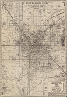
Map of Las Vegas Valley area, 1969
Date
1969
Description
'Featuring Las Vegas ... North Las Vegas ... Paradise Valley.' '1969 edition - revised' -- top of map. Original publisher: Front-Boy Service Co. 1969 ed. Scale [ca. 1:79,200]. 'Copyright - Russell A. Meador, 1968.' Front panel title: 'Front Boy's official 1969 edition street map.' Indexes on map verso. 'Walt Choik, editor, Front Boy Maps' -- back panel.
Text
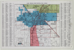
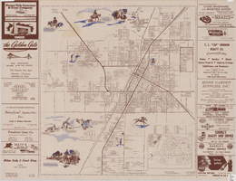
General map of Las Vegas, Nevada, June 1962
Date
1962-06
Description
At top of map: 'Las Vegas Metropolitan Area.' 'June 1962.' Includes indexes and information about Las Vegas. Published by Campbell Realty. Scale [ca. 1:31,680. 1 in. to approx. .5 miles].
Text

Map of metropolitan Las Vegas, Nevada area, circa 1957
Date
1955 to 1960
Description
Compiled and drawn by California State Automobile Association.--Panel ; "California State Automobile Association. Nevada Division." ; Includes indexes ; Includes inset maps of Nellis Air Force Base and area bounded on the north by Cheyenne Ave. and by Charleston Blvd. on the south. Signature of Elton M. Garrett of back of map. California State Automobile Association.
Text

City of Las Vegas map, 1952
Date
1952
Description
General information on Las Vegas and index on verso ; Copyright held by Redwood Publishing Co. ; Includes inset map of the Strip (U.S. 91 or Los Angeles Highway) ; Redwood Publishing Company
Text
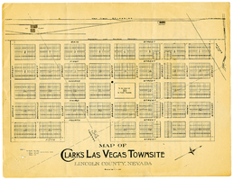
Map of Clark's Las Vegas Townsite, Lincoln County, Nevada, May 10, 1905
Date
1905-05-10
Archival Collection
Description
Scale: 1" = 100'. 1 map ; 28 x 22 cm. Verso of map is an announcement of the auction to be held May 15, 1905, for lots in the Las Vegas townsite. Pricing and lot information is included, as well as specials for railway tickets to Las Vegas from Los Angeles and Salt Like City. Las Vegas Land and Water Company
Text
Map of the city of Las Vegas, North Las Vegas, the "Strip", 1957
Date
1957
Description
35 x 50 cm., folded to 22 x 10 cm. 1958 edition. Copyright held by Robert E. Barringer. Panel title: Welcome map, greater Las Vegas area and scenic routes to and from there. "The Raele McCoy Co." Map is irregularly shaped. Index on verso. Includes advertisements for Las Vegas businesses and notes. Birdseye-view map The Las Vegas area : wonderland of the West : on the Old Spanish Trail; advertisements and helpful information on Las Vegas on verso. "1958 edition." Original publisher: Redwood Publishing Co..
Image

Map of the city of Las Vegas, North Las Vegas, the "Strip", 1963
Date
1963
Description
39 x 36 cm., folded to 28 x 15 cm. Panel title: Welcome map, greater Las Vegas area and scenic routes to and from there. Copyright held by Robert E. Barringer. Includes advertisements for Las Vegas businesses, inset of map of Henderson, Nev., and index. Map of California from San Francisco to Los Angeles to Las Vegas by Beth Bergh, advertisements and index on verso Christmas ed. Greater Las Vegas, 1963-1964 ed. Original publisher: Redwood Publishing Co..
Image
Map of the city of Las Vegas, North Las Vegas, and the "Strip", 1956
Date
1956
Description
40 x 37 cm., folded to 28 x 15 cm. Copyright held by Robert E. Barringer. Panel title: Welcome map, greater Las Vegas area and scenic routes to and from there. Includes inset map of Boulder City. Map of California from San Francisco to Los Angeles to Las Vegas by Beth Bergh on verso. Includes notes. Index on verso. Includes advertisements for Las Vegas and California businesses. Original publisher: Redwood Publishing Co..
Image

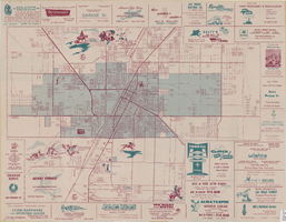
Street map of the Las Vegas area, circa 1960
Date
1959 to 1960
Description
53 x 65 cm., folded to 22 x 9 cm. Panel title: Welcome map & established guide to the greater Las Vegas area and scenic routes to and from there. Includes index and advertisements for local businesses. Las Vegas Motel Association map on verso along with advertisements, information on the Las Vegas Convention Center, and sightseeing information. Map was probably distributed by the Las Vegas Chamber of Commerce. Library's copy has freeway, service road, and streets connecting to the freeway marked with different colors of crayon and includes notes. 1960 ed. Map is irregularly shaped. Original publisher: Las Vegas Motel Association.
Image

Street map of greater Las Vegas, Nevada, 1965-1966
Date
1965 to 1966
Description
Rev. 1965-1966 ed. 55 x 42 cm., folded to 29 x 12 cm. Panel title: Front Boy's official street map. Relief shown by spot heights. Copyright held by Russell A. Meador. Includes notes, quotations and indexes. Street index on verso. "Detailed guide of North Las Vegas, Las Vegas, Paradise Valley, and vicinity." Original publisher: Meador, Russell A.
Image