
Search the Special Collections and Archives Portal

Search Results

Display    Results Per Page
Displaying results 21 - 30 of 575574

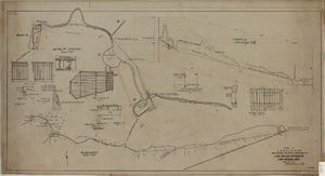
Map showing proposed improvement of Las Vegas Springs, Las Vegas, Nevada, September 21, 1916

Date

1916-09-21

Description

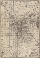
'Exhibit A'. 'Approved Sept. 21, 1916.' 'W.E.J.'"--Lower left corner. 'L-44-50 to 61. T-75 - 17 & 46'--Upper left corner. Includes discharge figures and plans for improvements to springs Scale [ca. 1:240]. 1 in. to 20 feet. -- Scale [ca. 1:2,400]. 1 in. to 200 ft. Vertical scale [ca. 1:48]. 1 in. to 4 feet. -- Scale [ca. 1:4,800]. 1 in. to 100 feet. Library's copy has "Proposed layout" written on it in pencil near lower center and other markings in red. Contents: Detail at springs -- Profile -- Alignment.

Image

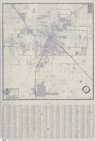
Street map of Las Vegas and vicinity, 1960

Date

1960

Description

43 x 40 cm., folded to 18 x 9 cm. Panel title: Las Vegas and vicinity map. Includes index. Text with facts about Las Vegas, photographs of Las Vegas and nearby tourist attractions and maps of Henderson, Boulder City and downtown Las Vegas on verso. Library's copy 2 has notes handwritten in black ink. Original publisher: Thomas Bros. Maps.

Image

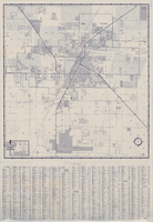
Street map of Las Vegas and vicinity, 1962

Date

1962

Description

43 x 40 cm., folded to 18 x 9 cm. Panel title: Las Vegas and vicinity. "Richfield" below title." Includes index. Text with facts about Las Vegas, photographs of Las Vegas and nearby tourist attractions and maps of Henderson, Boulder City and downtown Las Vegas on verso. Original publisher: Thomas Bros. Maps, Scale: One inch equals approximately 0.68 mile.

Image

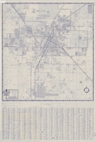
Street map of Las Vegas and vicinity, 1961

Date

1961

Description

43 x 40 cm., folded to 18 x 9 cm. Panel title: Las Vegas and vicinity map. Includes index. Text with facts about Las Vegas, photographs of Las Vegas and nearby tourist attractions and maps of Henderson, Boulder City and downtown Las Vegas on verso. Library's copy 2 has notes handwritten in black ink. Original publisher: Thomas Bros. Maps, Scale: One inch equals approximately 0.68 mile.

Image

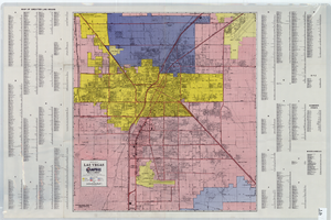
City map of Las Vegas, 1973

Date

1905-05-26

Description

Color; 55 x 45 cm., on sheet 95 x 47 cm., folded to 24 x 10 cm. Panel title: Las Vegas city map. Copyright held by Cardinal Publishing Company. Relief shown by hachures. Includes illustrations and advertisements. Index, text, illustrations, advertisements, and map of "Lake Mead National Recreation Area, lower basin section" on verso. Original publisher: Cardinal Publishing Company.

Image

Topographic map of Nevada-California, Las Vegas quadrangle, March 1908

Date

1908-03

Description

'Edition of Mar. 1908.' 'E.M. Douglas, geographer in charge; Topography and triangulation by R.H. Chapman, B.D. Stewart, J.E. Blackburn, and D.F.C. Moor. Surveyed in 1906-1907.' Scale 1:250,000 (W 116°00--W 115°00/N 37°00--N 36°00). Relief shown by contours and spot heights. Title in lower-right corner: Las Vegas. Contour interval 100 feet. Datum is mean sea level. "Topography"--Center of top margin. Text about the Topographic Maps of the United States series and symbols used on map on verso. U.S. Geological Survey

Text

Las Vegas Valley map, Clark County, Nevada, June 1958

Date

1958

Description

'Compiled 1954. First revision - June 1958.' 'Area extends 9 miles north, 11 miles south, and 3 miles east, 3 miles west city limits of Las Vegas.' Original publisher: Campbell Realty. Scale [ca. 1:60,000. 1 in. to approx. 5,000 ft.]. Cadastral map. Hand-drawn red line around some sections on map.

Image

A general map of Las Vegas, 1969

Date

1905-05-22

Description

Color; 60 x 55 cm. on sheet 64 x 96 cm. At top left of map: Map of greater Las Vegas. Includes index.

Image

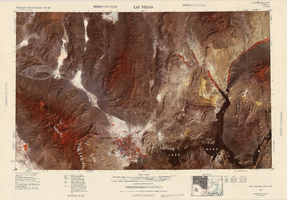
Satellite image map of the Las Vegas Valley, 1981

Date

1981

Description

'1981. Experimental edition 36114-A1-SI-250.' Scale 1:250,000 ; Transverse Mercator proj. (W 116°--W 114°/N 37°--N 36°). Series: Western United States 1:250,000. Western United States 1:250,000 ; NJ 11-12. Filing title: Las Vegas, Nev.; Ariz.; Calif. 'Imagery recorded with Multispectral Scanner (MSS) on NASA Landsat-3.' Includes image coverage diagram. Separate map on verso: Las Vegas / prepared by the U.S. Army Topographic Command ; revised by the U.S. Geological Survey 1969. Ed. 5. Washington, D.C. : Geological Survey, 1976, NJ 11-12 in the series Western United States 1:250,000. United States Geological Survey

Image

Map of Las Vegas Valley area, 1969

Date

1969

Description

'Featuring Las Vegas ... North Las Vegas ... Paradise Valley.' '1969 edition - revised' -- top of map. Original publisher: Front-Boy Service Co. 1969 ed. Scale [ca. 1:79,200]. 'Copyright - Russell A. Meador, 1968.' Front panel title: 'Front Boy's official 1969 edition street map.' Indexes on map verso. 'Walt Choik, editor, Front Boy Maps' -- back panel.

Text