Search Results
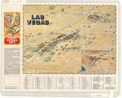
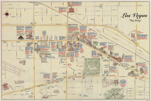
Map of the Las Vegas Strip, downtown Las Vegas and surrounding areas, 1987
Date
1987
Description
Panel title: Las Vegas illustrated pocket map. Bird's-eye view map of the Strip and downtown Las Vegas. Shows casinos, motels, golf courses, recreational vehicle parks, and other places of interest to tourists. Includes indexes. Includes text and inset map of locations of other cities and sites of interest to tourists in the surrounding states and their distances from Las Vegas. Travel Graphics International (Firm)
Text
Map of Las Vegas, North Las Vegas, and vicinity, June 1975
Date
1975-06
Description
'Cartographic Department. Copyright by California State Automobile Association. C6-75.' 'Issued by California State Automobile Association and Automobile Club of Southern California. 6-75' on front panel. Indexes on map verso. Scale [ca. 1:32,400. 1 in. to approx. 2700 ft.]. California State Automobile Association.
Text
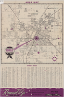
Street map of Las Vegas and North Las Vegas, circa 1963
Date
1961 to 1965
Description
36 x 37 cm. Panel title: Las Vegas area map. Includes index. Advertisements for Round-up Real Estate on verso. Original publisher: Round.
Image
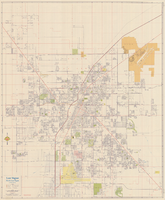
Street map of Las Vegas, North Las Vegas and vicinity, circa 1969
Date
1905-05-22
Description
Color; 100 x 58 cm., folded to 24 x 11 cm. "569." Indexes on verso. Library's copy has a small piece missing along the left-hand side of the map. Original publisher: California State Automobile Association.
Image
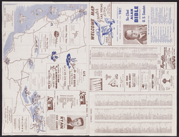
Map of Las Vegas, North Las Vegas, and The Strip, 1956
Date
1956
Description
1956 ed. 'Compiled by Redwood Publishing Co. Copyright 1956 by Robert E. Barringer ... Las Vegas, Nevada.' Panel title: Welcome map, greater Las Vegas area and scenic routes to and from there. Map of California from San Francisco to Los Angeles to Las Vegas drawn by Beth Bergh. Includes notes and street index. Includes advertisements for Las Vegas and California businesses. Scale [ca. 1:35,640. 1 in. to approx. 0.56 mile].
Text
Maps of the Las Vegas Strip, downtown and metropolitan Las Vegas area, the Grand Canyon and southern Nevada, circa 1997
Date
1995 to 1999
Description
'Detail maps for downtown, neighborhoods, out of town, Grand Canyon' -- front panel. Maps on verso: Downtown -- Out of town and short adventures -- Greater Las Vegas -- Grand Canyon, South Rim Village. Major buildings and points of interest on the Las Vegas Strip shown pictorially. Includes text and notes. Originally published by MapEasy, Inc. Scale [ca. 1:10,560. 1 inch to approximately 1/6 mile].
Text
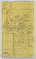
Street map of Las Vegas and vicinity, 1965
Date
1905-05-18
Description
1965 [ed.]. Color; 70 x 55 cm., folded to 24 x 10 cm. Panel title: Las Vegas, North Las Vegas and vicinity street map, home buyers guide. "1/65." Includes names of subdivisions. Index and advertisements for subdivisions on verso. "Compliments of First Western Savings & Loan Association."--Panel. "Drawn by Bob and Beverly Bennett, 1/65." Original publisher: Amusement Guide Publications of America.
Image
Greater Las Vegas, 1957
Date
1957
Description
42 x 44 cm., folded to 22 x 14 cm. Title in upper-right margin: Greater Las Vegas. Copyright held by Robert E. Barringer. Includes index. Map is irregularly shaped. Original publisher: Redwood Publishing Co..
Image
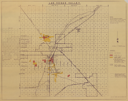
Map of Las Vegas Valley, 1968
Date
1968
Description
'This map compiled by General Drafting Service to show purchases in the Las Vegas area by Howard Hughes and others reported to be affiliated with him.' Shows land owned by Howard Hughes and land owned by Hughes Tool Company. Includes locations of casinos on Las Vegas Strip. Original publisher: General Drafting Service. Scale [ca. 1:48,000]. 1 in. to 4,000 feet. Hand-colored.
Image
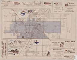
Map of the city of Las Vegas, North Las Vegas, the "Strip", 1957
Date
1957
Description
35 x 50 cm., folded to 22 x 10 cm. Panel title: Inside the greater Las Vegas area. Copyright held by Robert E. Barringer. Map is irregularly shaped. Map of California from San Francisco to Los Angeles to Las Vegas by Beth Bergh, index and advertisements on verso. Includes advertisements for Las Vegas businesses. Stamped on panel of Library's copy: Harrington Insurance Agency. Original publisher: Redwood Publishing Co..
Image