Search Results

Topographic map of the northwest quadrangle of the metropolitan Las Vegas, Nevada area, 1967
Date
1967
Description
Scale 1:24,000 ; polyconic proj. (W 115°1500--W 115°730/N 36°1500--N 36°730) ; 1 map : col. ; 58 x 47 cm ; 7.5 minute series (topographic) ; Relief shown by contours and spot heights ; Filing title: Las Vegas NW, Nev ; "AMS 2956 II NW--Series V896." ; Contour interval 10 feet ; "Topography by photogrammetric methods from aerial photographs taken 1965. Field checked 1967." ; Includes quadrangle location map ; Interior--Geological Survey
Image

Topographic map of the southeast quadrangle of the metropolitan Las Vegas, Nevada area, 1967
Date
1967
Description
Scale 1:24,000 ; polyconic proj. (W 115°0730--W 115°0000/N 36°0730--N 36°0000) ; 1 map : col. ; 58 x 47 cm ; 7.5 minute series (topographic) ; Relief shown by contours and spot heights ; Filing title: Las Vegas SE, Nev ; "AMS 2956 II SE--Series V896." ; Contour interval 20 feet ; "Topography by photogrammetric methods from aerial photographs taken 1965. Field checked 1967." ; Includes quadrangle location map ; Interior--Geological Survey
Image

Topographic map of the southwestern quadrangle of the metropolitan Las Vegas, Nevada area, 1967
Date
1967
Description
Scale 1:24,000 ; polyconic proj. (W 115°1500--W 115°0730/N 36°0730--N 36°0000) ; 1 map : col. ; 58 x 47 cm ; 7.5 minute series (topographic) ; Relief shown by contours and spot heights ; Filing title: Las Vegas SW, Nev ; "AMS 2956 II SW--Series V896." ; Contour interval 10 feet ; "Topography by photogrammetric methods from aerial photographs taken 1965. Field checked 1967." ; Includes quadrangle location map ; Interior--Geological Survey
Image
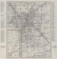
Street map of greater Las Vegas, 1963
Date
1963
Description
55 x 44 cm. Panel title: Front Boy's official 1963-1964 edition street map : detailed guide of North Las Vegas, Las Vegas, Paradise Valley and vicinity. Relief shown by spot heights. Originally folded to: 29 x 12 cm. "Note, revised and recorded 1st - 1961, 2nd - 1962, 3rd 1963, 4th - 1963."On verso: "MAR 1964" stamped in red ink on upper right hand corner. Includes notes and quotations. Includes indexes. Original publisher: Front.
Image

Topographic map of the southwestern quadrangle of the metropolitan Las Vegas, Nevada area, 1973
Date
1973
Description
Scale 1:24,000 ; polyconic proj. (W 115°1500--W 115°0730/N 36°0730--N 36°0000) ; 1 map : col. ; 58 x 47 cm ; 7.5 minute series (topographic) ; Relief shown by contours and spot heights ; Filing title: Las Vegas SW, Nev ; "AMS 2956 II SW--Series V896." ; Contour interval 10 feet ; "Topography by photogrammetric methods from aerial photographs taken 1965. Field checked 1967." ; "Map photoinspected 1973. No major culture or drainage changes observed." ; Includes quadrangle location map ; Interior--Geological Survey
Image

Topographic map of the northeast quadrangle of the metropolitan Las Vegas, Nevada area, 1973
Date
1973
Description
Scale 1:24,000 ; polyconic proj. (W 115°730--W 115°0000/N 36°1500--N 36°730) ; 1 map : col. ; 58 x 47 cm ; 7.5 minute series (topographic) ; Relief shown by contours and spot heights ; "AMS 2956 II NE--Series V896." ; Contour interval 20 feet ; "Topography by photogrammetric methods from aerial photographs taken 1965. Field checked 1967." ; "Revisions shown in purple compiled from aerial photographs taken 1973. This information not field checked." ; Includes quadrangle location map ; Filing title: Las Vegas, NE, Nev ; Interior--Geological Survey
Image

Topographic map of the northwest quadrangle of the metropolitan Las Vegas, Nevada area, 1973
Date
1973
Description
Scale 1:24,000 ; polyconic proj. (W 115°1500--W 115°730/N 36°1500--N 36°730) ; 1 map : col. ; 58 x 47 cm ; 7.5 minute series (topographic) ; Relief shown by contours and spot heights ; Filing title: Las Vegas NM, Nev ; "AMS 2956 II NW--Series V896." ; Contour interval 10 feet ; "Topography by photogrammetric methods from aerial photographs taken 1965. Field checked 1967." ; "Revisions shown in purple compiled from aerial photographs taken 1973. This information not field checked." ; Includes quadrangle location map ; Interior--Geological Survey
Image

Topographic map of the southeast quadrangle of the metropolitan Las Vegas, Nevada area, 1973
Date
1973
Description
Scale 1:24,000 ; polyconic proj. (W 115°0730--W 115°0000/N 36°0730--N 36°0000) ; 1 map : col. ; 58 x 47 cm ; 7.5 minute series (topographic) ; Relief shown by contours and spot heights ; Filing title: Las Vegas SE, Nev ; "AMS 2956 II SE--Series V896." ; Contour interval 20 feet ; "Topography by photogrammetric methods from aerial photographs taken 1965. Field checked 1967." ; "Revisions shown in purple compiled from aerial photographs taken 1973. This information not field checked." ; Includes quadrangle location map ; Interior--Geological Survey
Image

Topographic map of the southeast quadrangle of the metropolitan Las Vegas, Nevada area, 1984
Date
1984
Description
Scale 1:24,000 ; polyconic proj. (W 115°0730--W 115°0000/N 36°0730--N 36°0000) ; 1 map : col. ; 58 x 47 cm ; 7.5 minute series (topographic) ; Relief shown by contours and spot heights ; Filing title: Las Vegas SE, Nev ; "DMA 2956 II SE--Series V896." ; Contour interval 20 feet ; "Topography by photogrammetric methods from aerial photographs taken 1965. Field checked 1967." ; "Revisions shown in purple and woodland compiled from aerial photographs taken 1982 and other sources. This information not field checked. Map edited 1984." ; Includes quadrangle location map ; Interior--Geological Survey
Image

Map of Las Vegas Valley, Clark County, Nevada, 1954
Date
1954
Description
Scale [ca. 1:63,360. 1 in. to approx. 5,280 ft.].Cadastral map. 'Compiled for C.D. Baker, Reg. Civil Engineer Nevada No. 6 and Licensed Real Estate Broker by Tyson Engineering Co., Las Vegas, Nevada.' 'Copyright 1954 Tyson Engineering Co., Las Vegas, Nevada. Drawn by E.M. Ballinger' Tyson Engineering Company
Image