Search the Special Collections and Archives Portal
Search Results
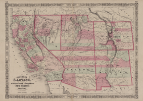
Map of California, with territories of Utah, Nevada, Colorado, New Mexico, and Arizona, 1864
Date
1864
Description
40 x 62 cm. Relief shown by hachures. Prime meridians: Greenwich and Washington. Page numbers at top: 58-59. "Entered according to act of Congress in the year 1864 by A. J. Johnson in the Clerk's Office of the District Court of the United States for the Southern District of New York." Original publisher: Johnson and Ward.
Image
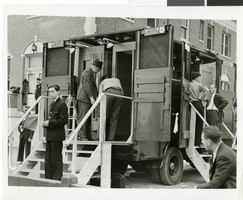
Photograph of Howard Hughes' arrival, New York, July 14, 1938
Date
1938-07-14
Archival Collection
Description
The black and white view of men assembling a truck loaded with old telephone booths for Howard Hughes arrival in New York. Typed onto a piece of paper attached to the image: "Telephone company "goes to town" for Hughes' arrival, New York City -- Something had to be done to take care of the thousands of potential telephone users who crowded Floyd Bennett Field, July 14th, for the arrival of Howard Hughes and his daring crew on their dash Around the World, so the New York Telephone Company, well aware of the fact that the few phones at the field couldn't possibly accommodate, the officials, police, and spectators, "went to town" with a truck loaded with old telephone booths. A line was quickly strung and the phones in the booths on the truck were plugged in. The business was rushing and the phone company was well rewarded for its enterprise. Credit Line (ACME) 7/14/38."
Image
#69195: Honors College student Matthew Buyachek for Admissions Student Profile on July 15, 2013, 2013 July 15
Level of Description
File
Archival Collection
University of Nevada, Las Vegas Creative Services Records (2010s)
To request this item in person:
Collection Number: PH-00388-05
Collection Name: University of Nevada, Las Vegas Creative Services Records (2010s)
Box/Folder: Digital File 00
Collection Name: University of Nevada, Las Vegas Creative Services Records (2010s)
Box/Folder: Digital File 00
Archival Component
Griffith's Resort, Nevada, 1928 July 15
Level of Description
File
Archival Collection
Chester R. Longwell Professional Papers
To request this item in person:
Collection Number: MS-00017
Collection Name: Chester R. Longwell Professional Papers
Box/Folder: Box 03
Collection Name: Chester R. Longwell Professional Papers
Box/Folder: Box 03
Archival Component
Lion Compass, menu, 1982 July 15
Level of Description
File
Archival Collection
UNLV University Libraries Menu Collection
To request this item in person:
Collection Number: MS-00436
Collection Name: UNLV University Libraries Menu Collection
Box/Folder: Box 64
Collection Name: UNLV University Libraries Menu Collection
Box/Folder: Box 64
Archival Component
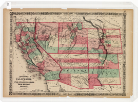
Map of California, Utah, Nevada, Colorado, New Mexico and Arizona, 1864
Date
1864
Description
'Johnson's California, with Utah, Nevada, Colorado, New Mexico, and Arizona, published by Johnson and Ward.' 'Entered according to Act of Congress in the Year 1864 by A.J. Johnson in the Clerks Office of the District Court of the United States for the southern district of New York.' Atlas page numbers in upper margin: 66-67. This is probably plate 67 from Johnson's New Illustrated Family Atlas, published in New York by Johnson & Ward in 1864. Shows natural features, locations of Indian tribes, proposed railroad routes, routes of explorers, trails, county boundaries and populated places ; "." ; Relief shown by hachures ; Prime meridians: Greenwich and Washington ; In top margin: 66-67 ; Hand colored ; On verso: Historical and statistical view of Mexico and central America (p. 79) and Historical and statistical view of the United States, 1860 (p. 78) Scale [ca. 1:3,484,800]. 1 in. to ca. 55 miles (W 124°--W 102°/N 42°--N 32°)
Text
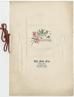
The New Fay Easter dinner menu, Sunday, April 7, 1912
Date
1912-04-07
Archival Collection
Description
Restaurant: The New Fay (Virginia, Minn.) Location: Virginia, Minnesota, United States
Text
New York Hard Bop Quintet: multiple, 1995 July 6
Level of Description
File
Archival Collection
KNPR: "Monday Night Jazz" Program Documentation and Recordings
To request this item in person:
Collection Number: MS-00456
Collection Name: KNPR: "Monday Night Jazz" Program Documentation and Recordings
Box/Folder: N/A
Collection Name: KNPR: "Monday Night Jazz" Program Documentation and Recordings
Box/Folder: N/A
Archival Component
"Bobby the K." interview with Ruchman, 1999 July 15
Level of Description
File
Archival Collection
Penelope Ruchman Collection of Las Vegas, Nevada Casino Professionals Oral Histories
To request this item in person:
Collection Number: MS-00907
Collection Name: Penelope Ruchman Collection of Las Vegas, Nevada Casino Professionals Oral Histories
Box/Folder: Box 01, Digital File 00
Collection Name: Penelope Ruchman Collection of Las Vegas, Nevada Casino Professionals Oral Histories
Box/Folder: Box 01, Digital File 00
Archival Component
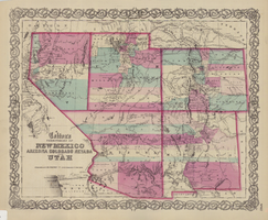
Map of the territories of New Mexico, Arizona, Colorado, Nevada, and Utah, 1855
Date
1855
Description
29 x 36 cm. Relief shown by hachures. Prime meridians: Greenwich and Washington. "Entered according to act of Congress in the year 1855 by J.H. Colton & Co. in the Clerk's Office of the Dist. Office of the U.S. for the Southern. Dist. of New York." Hand colored. Decorative border. Atlas p. number in lower-right margin: 67. Shows routes of explorers, proposed railroad routes, wagon route, mail route, Indian reserves and mines. On verso: History and statistical view of Mexico. Original publisher: J.H. Colton.
Image
Pagination
Refine my results
Content Type
Creator or Contributor
Subject
Archival Collection
Digital Project
Resource Type
Year
Material Type
Place
Language
Records Classification
