Search Results
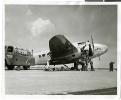
Photograph of mechanics with the Lockheed 14 aircraft, New York, July 10, 1938
Date
1938-07-10
Archival Collection
Description
The black and white view of a plane used by Howard Hughes being fueled up at Floyd Bennett Field in New York.
Image
Wilbur and Toni Clark at a formal dinner at the Hotel Astor in New York City, New York, 1958
Level of Description
File
Archival Collection
Toni and Wilbur Clark Photographs
To request this item in person:
Collection Number: PH-00302
Collection Name: Toni and Wilbur Clark Photographs
Box/Folder: Folder 10
Collection Name: Toni and Wilbur Clark Photographs
Box/Folder: Folder 10
Archival Component
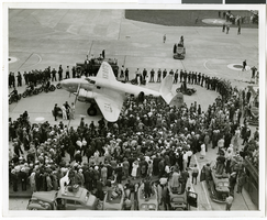
Photograph of crowds at Floyd Bennett Airfield, New York, July 14, 1938
Date
1938-07-14
Archival Collection
Description
The black and white view of Howard Hughes' Lockheed 14 aircraft after performing its final landing on the Round the World flight at Floyd Bennett Airport, New York. Description printed on photograph's accompanying sheet of paper: "Police circle Lockheed-14 at Floyd Bennett Airport."
Image

Map of California, Utah, Nevada, Colorado, New Mexico and Arizona, circa 1867
Date
1865 to 1869
Description
39 x 56 cm. Relief shown by hachures. "Entered according to act of Congress in the year 1864, by A.J. Johnson in the Clerks Office of the United States for the Southern District of New York." Atlas page numbers in upper margin: 67-68. Primer meridians: Greenwich and Washington, D.C. On verso: History and statistical view of the West India islands or Columbian Archipelago and Historical and statistical view of Mexico and Central America. Shows proposed railroads, locations of Indian tribes, natural features, counties, mines, mail routes, trails and routes of exploring expeditions. Has decorative border. Southern part of Nevada was added to the state in 1867 and is part of Nevada on this map, but Lincoln County was established in 1867 and is not on this map. This map was still probably published in 1867 in spite of someone's having written "1864" in pencil in the lower right corner of the Library's copy. Original publisher: A.J. Johnson.
Image
#69800: UNLV Libraries employees pose for portraits July 15, 2014 at the University of Nevada, Las Vegas, 2014 July 15
Level of Description
File
Archival Collection
University of Nevada, Las Vegas Creative Services Records (2010s)
To request this item in person:
Collection Number: PH-00388-05
Collection Name: University of Nevada, Las Vegas Creative Services Records (2010s)
Box/Folder: Digital File 00
Collection Name: University of Nevada, Las Vegas Creative Services Records (2010s)
Box/Folder: Digital File 00
Archival Component
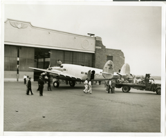
Photograph of the Lockheed 14 aircraft at Floyd Bennnett Airport, New York, July 9, 1938
Date
1938-07-09
Archival Collection
Description
The black and white view of the Lockheed 14 aircraft at the Floyd Bennett Airport in New York. Typed on a piece of paper attached to the image: "Readying Hughes' plane for Paris flight. New York City-- Mechanics hastened to put Howard Hughes' Lockheed 14 monoplane in shape for a flight from Floyd Bennett Airport here, to Paris. Motor trouble forced postponement and helpers were working under injunction to have the ship ready for a takeoff, July 9, "at the earliest possible moment." Photo shows: the plane being pulled out of the hangar by a truck. Credit Line (ACME) 7/9/38."
Image
Del Webb's Sahara Boardwalk-Atlantic City, New Jersey
Level of Description
File
Archival Collection
Martin Stern Architectural Records
To request this item in person:
Collection Number: MS-00382
Collection Name: Martin Stern Architectural Records
Box/Folder: N/A
Collection Name: Martin Stern Architectural Records
Box/Folder: N/A
Archival Component
Harrah's Marina Hotel Casino: Atlantic City, New Jersey
Level of Description
Series
Archival Collection
Martin Stern Architectural Records
To request this item in person:
Collection Number: MS-00382
Collection Name: Martin Stern Architectural Records
Box/Folder: N/A
Collection Name: Martin Stern Architectural Records
Box/Folder: N/A
Archival Component

City of Las Vegas map, 1952
Date
1952
Description
General information on Las Vegas and index on verso ; Copyright held by Redwood Publishing Co. ; Includes inset map of the Strip (U.S. 91 or Los Angeles Highway) ; Redwood Publishing Company
Text
Rex Bell in Boulder City, Nevada on with two unidentified women: Handwritten on back "July 4, 1955, Boulder City", 1955 July 04
Level of Description
File
Archival Collection
Walking Box Ranch Photograph Collection
To request this item in person:
Collection Number: PH-00346
Collection Name: Walking Box Ranch Photograph Collection
Box/Folder: N/A
Collection Name: Walking Box Ranch Photograph Collection
Box/Folder: N/A
Archival Component