Search Results
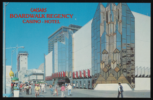
Caesar's Boardwalk Regency Hotel and Casino in Atlantic City, New Jersey: postcard
Date
1940 (year approximate) to 1990 (year approximate)
Archival Collection
Description
From Harvey's Hotel and Casino Postcard Collection (PH-00367)
Image
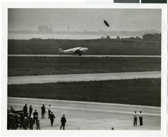
Photograph of the landing of Howard Hughes' Lockheed 14 aircraft, New York, July 14, 1938
Date
1938-07-14
Archival Collection
Description
The black and white, aerial view of Howard Hughes' Lockheed 14 aircraft performing its final landing on the Round the World flight at Floyd Bennett Airport, New York.
Image
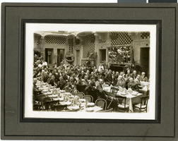
Photograph of Fleming and Ida Hubbard at J. C. Penney convention, Atlantic City, New Jersey, circa early 1900s
Date
1900 to 1939
Archival Collection
Description
Fleming Ballew Hubbard and Ida Mae Conklin Hubbard, seated next to turned up chair, with other unidentified people at a J. C. Penney Convention held in Atlantic City, New Jersey.
Image


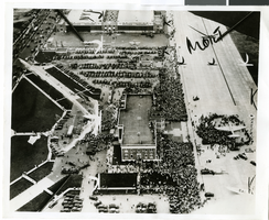
Photograph of the landing of Howard Hughes' Lockheed 14 aircraft, New York, July 14, 1938
Date
1938-07-14
Archival Collection
Description
The black and white, aerial view of Howard Hughes' Lockheed 14 aircraft preparing for its final landing on its Round the World flight in Floyd Bennett Field, New York.
Image

Photograph of the landing of Howard Hughes' Lockheed 14 aircraft, New York, July 14, 1938
Date
1938-07-14
Archival Collection
Description
The black and white, aerial view of Howard Hughes' Lockheed 14 aircraft after performing its final landing on the Round the World flight at Floyd Bennett Airport, New York.
Image
Showboat Atlantic City Photograph Collection
Identifier
PH-00329
Abstract
The Showboat Atlantic City Photograph Collection (1986) contains black-and-white and color photographic prints and conceptual sketches of the Showboat Casino in Atlantic City, New Jersey. The photographs depict casino patrons in various locations throughout the Showboat, and the sketches show exterior and interior designs.
Archival Collection
City of North Las Vegas, urban renewal, 1963 July 05
Level of Description
File
Archival Collection
Frank Mitrani Photographs
To request this item in person:
Collection Number: PH-00332
Collection Name: Frank Mitrani Photographs
Box/Folder: Box 11
Collection Name: Frank Mitrani Photographs
Box/Folder: Box 11
Archival Component
Cleland, C. R., North Las Vegas City Council, 1969 July 28
Level of Description
File
Archival Collection
Frank Mitrani Photographs
To request this item in person:
Collection Number: PH-00332
Collection Name: Frank Mitrani Photographs
Box/Folder: Box 03
Collection Name: Frank Mitrani Photographs
Box/Folder: Box 03
Archival Component