Search the Special Collections and Archives Portal
Search Results
Howard Hughes and his crew at a parade after he completed his around-the-world flight in New York, 1938 July 15
Level of Description
Archival Collection
Collection Name: Howard Hughes Public Relations Photograph Collection
Box/Folder: Folder 10
Archival Component
Howard Hughes and his crew at a parade after he completed his around-the-world flight in New York, 1938 July 15
Level of Description
Archival Collection
Collection Name: Howard Hughes Public Relations Photograph Collection
Box/Folder: Folder 10
Archival Component
Howard Hughes and his crew at a parade after he completed his around-the-world flight in New York, 1938 July 15
Level of Description
Archival Collection
Collection Name: Howard Hughes Public Relations Photograph Collection
Box/Folder: Folder 10
Archival Component

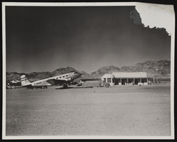
Photograph of a plane, Boulder City (Nev.), December 22, 1938
Date
Archival Collection
Description
Image
New York-New York Hotel and Casino 9-11 Heroes Tribute Collection
Identifier
Abstract
The New York-New York Hotel and Casino 9-11 Heroes Tribute Collection consists of materials from the "Heroes of 9-11" display that was at the New York-New York Hotel and Casino in Las Vegas, Nevada from 2001 to 2012. The materials primarily consist of more than 5,000 t-shirts left at the memorial by visitors to Las Vegas, mostly from fire departments and law enforcement agencies from around the United States. Visitors left shirts and other items at the memorial as a sign of respect for the men and women who died during the terrorist attacks in New York City and Washington, D.C. on September 11, 2001. The collection also houses memorabilia and other items left at the memorial, including flags, hats, pins, buttons, flowers, and embroidered emblems and insignias. The materials also contain documentation of the memorial, including promotional and press materials, video recordings from the news media, photographs, and newspaper articles.
Archival Collection
"Tax Payers’ Guide" 1926 (booklet) and 1938 Los Angeles, 1926-1938
Level of Description
Archival Collection
Collection Name: Union Pacific Railroad Collection
Box/Folder: Box 71
Archival Component
Spectators gathered around the Lockheed-14 at Floyd Bennett Airport, New York, to watch Howard Hughes take off, 1938 July 10
Level of Description
Archival Collection
Collection Name: Howard Hughes Professional and Aeronautical Photographs
Box/Folder: Folder 05
Archival Component
Howard Hughes at the microphone, during his brief address at welcoming ceremonies in the Council Chamber at City Hall, New York, 1938 July 15
Level of Description
Archival Collection
Collection Name: Howard Hughes Public Relations Photograph Collection
Box/Folder: Folder 12
Archival Component
Willapa Harbor and Florence, Oregon: photographic negative, approximately 1938 April to 1938 May
Level of Description
Archival Collection
Collection Name: Nan Doughty Photograph Collection
Box/Folder: Box SH-028
Archival Component
Picture of unknown couple, 1938
Level of Description
Archival Collection
Collection Name: Walking Box Ranch Photograph Collection
Box/Folder: N/A
Archival Component
