Search Results

Map of the territories of New Mexico, Arizona, Colorado, Nevada, and Utah, 1855
Date
1855
Description
29 x 36 cm. Relief shown by hachures. Prime meridians: Greenwich and Washington. "Entered according to act of Congress in the year 1855 by J.H. Colton & Co. in the Clerk's Office of the Dist. Office of the U.S. for the Southern. Dist. of New York." Hand colored. Decorative border. Atlas p. number in lower-right margin: 67. Shows routes of explorers, proposed railroad routes, wagon route, mail route, Indian reserves and mines. On verso: History and statistical view of Mexico. Original publisher: J.H. Colton.
Image
Readers' News. London: published by Readers Union, 1938 November 15
Level of Description
Item
Archival Collection
Mavis Eggle "Books as They Were Bought" Collection
To request this item in person:
Collection Number: MS-01144
Collection Name: Mavis Eggle "Books as They Were Bought" Collection
Box/Folder: Box 23
Collection Name: Mavis Eggle "Books as They Were Bought" Collection
Box/Folder: Box 23
Archival Component
Police lined up ready for the start of the Howard Hughes parade, 1938 July 15
Level of Description
File
Archival Collection
Howard Hughes Public Relations Photograph Collection
To request this item in person:
Collection Number: PH-00373
Collection Name: Howard Hughes Public Relations Photograph Collection
Box/Folder: Folder 10
Collection Name: Howard Hughes Public Relations Photograph Collection
Box/Folder: Folder 10
Archival Component

Map of California, Utah, Nevada, Colorado, New Mexico and Arizona, 1864
Date
1864
Description
'Johnson's California, also Utah, Nevada, Colorado, New Mexico, and Arizona, published by A.J. Johnson, New York.' 'Entered according to Act of Congress in the Year 1864, by A.J. Johnson in the Clerks Office of the District Court of the United States for the Southern District of New York.' Atlas page numbers in upper margin: 66-67. Relief shown by hachures. Prime meridians: Greenwich and Washington, D.C. Shows proposed railroads, locations of Indian tribes, natural features, counties, mines, mail routes, trails and routes of exploring expeditions. On verso: History and statistics of Mexico and Central America and statistics of national finances and the Post Office of the United States, 1860. Scale [ca. 1:3,484,800. 1 in. to ca. 55 miles] (W 123°--W 103°/N 42°--N 32°)
Text
Howard Hughes is appointed Aeronautic Adviser to the 1939 New York World's Fair by Grover Whalen, 1938
Level of Description
File
Archival Collection
Howard Hughes Public Relations Photograph Collection
To request this item in person:
Collection Number: PH-00373
Collection Name: Howard Hughes Public Relations Photograph Collection
Box/Folder: Folder 10
Collection Name: Howard Hughes Public Relations Photograph Collection
Box/Folder: Folder 10
Archival Component
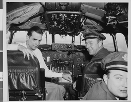
Photograph of Howard Hughes in cockpit, New York, February 15, 1946
Date
1946-02-15
Archival Collection
Description
Description given with photo: "After Non-Stop Coast to Coast Flight -- Pilot Howard Hughes (left) millionaire flier and movie producer, co-pilot Joseph Bartles, and navigator Robert Stevens, relax at the controls of their Lock-heed Constellation after landing at LaGuardia Field in new York City, Feb. 15 on Pre-Inaugural non-stop coast to coast flight from Burbank, Calif. the Constellation, named "Start of California" and carrying 34 passengers, including movie stars and a crew of seven, landed at LaGuardia Field eight hours and 38 minutes after leaving Burbank. 22/15/46."
Image

Savoy Restaurant menu, June 15, 1898
Date
1898-06-15
Archival Collection
Description
Note: Handwritten menu. "Déposé [registered] AD" [printer's monogram] printed under illustration on page 2. Illustration on page 2 shows a woman wearing a toga and sandals, with a raised wine glass and a scepter, riding atop a barrel being pulled by two oversized snails Restaurant: Savoy Restaurant
Text
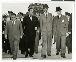
Photograph of Howard Hughes and Grover Whalen at Floyd Bennett Airfield, New York, July 14, 1938
Date
1938-07-14
Archival Collection
Description
A view of Howard Hughes and Grover Whalen leaving Floyd Bennett Airfield.
Image
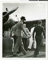
Photograph of Howard Hughes and the Lockheed 14 aircraft, Fairbanks, Alaska, July 15, 1938
Date
1938-07-15
Archival Collection
Description
The black and white view of Howard Hughes walking with other unidentified men toward the Lockheed 14 aircraft that was then being refueled. Hughes was then on his Around the World Flight where he visited Paris, Moscow, Fairbanks, and Alaska.
Image
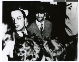
Photograph of Howard Hughes after arriving from his flight around the world, New York, July 13, 1938
Date
1938-07-13
Archival Collection
Description
Howard Hughes (center) in a New York City crowd of people after his around the world flight.
Image