Search Results
Howard Hughes and Grover Whalen at Floyd Bennett Field, New York, 1938 July 10
Level of Description
File
Archival Collection
Howard Hughes Public Relations Photograph Collection
To request this item in person:
Collection Number: PH-00373
Collection Name: Howard Hughes Public Relations Photograph Collection
Box/Folder: Folder 06
Collection Name: Howard Hughes Public Relations Photograph Collection
Box/Folder: Folder 06
Archival Component
People atop a tower awaiting the arrival of Howard Hughes, New York, 1938 July 14
Level of Description
File
Archival Collection
Howard Hughes Public Relations Photograph Collection
To request this item in person:
Collection Number: PH-00373
Collection Name: Howard Hughes Public Relations Photograph Collection
Box/Folder: Folder 08
Collection Name: Howard Hughes Public Relations Photograph Collection
Box/Folder: Folder 08
Archival Component

Map of California and Territories of New Mexico and Utah, 1862
Date
1862
Description
Scale [ca. 1:3,231,360. 1 in. to approx. 51 miles] (W 125°00--W 103°30/N 42°00--N 31°45) ; 1 map : hand col. ; 40 x 60 cm., on sheet 46 x 68 cm ; Relief indicated by hachures and spot heights ; Prime meridians: Greenwich and Washington, D.C ; Decorative border ; Hand colored ; Atlas p. numbers in upper margin: 58-59 ; Date est. from territorial borders and county configuration ; Shows natural features, locations of Indian tribes, proposed railroad routes, routes of explorers, trails, county boundaries and populated places ; Johnson and Ward
Image
Howard Hughes and Mayor Fiorello La Guardia seated in an automobile that was used in a parade dedicated to Hughes's completion of his around-the-world flight in New York City, 1938 July 15
Level of Description
File
Archival Collection
Howard Hughes Public Relations Photograph Collection
To request this item in person:
Collection Number: PH-00373
Collection Name: Howard Hughes Public Relations Photograph Collection
Box/Folder: Folder 13
Collection Name: Howard Hughes Public Relations Photograph Collection
Box/Folder: Folder 13
Archival Component
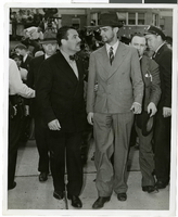
Photograph of Howard Hughes and Grover Whalen at Floyd Bennett Airfield, New York, July 14, 1938
Date
1938-07-14
Archival Collection
Description
A view of Howard Hughes and Grover Whalen at Floyd Bennett Airfield in New York. Description printed on photograph's accompanying sheet of paper: "Grover Whalen greets Hughes. New York City-- His face covered by stubble and still wearing his battered hat, Howard Hughes is taken in tow by Grover Whalen, World's Fair head, shortly after Hughes and his companions set their plane down at Floyd Bennett Airport here, completing their dramatic dash around the world. Credit Line (ACME) 7/14/38"
Image
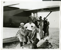
Photograph of Howard Hughes at a U.S. Coast Guard Station, January 15, 1938
Date
1938-01-15
Archival Collection
Description
Description printed on photograph's accompanying strip of paper: Howard Hughes being carried ashore after arrival in amphibian airplane at U.S. Coast Guard Station, Jamaica Bay, B.W.I.
Image