Search Results
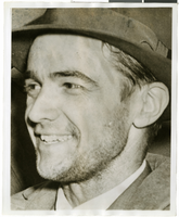
Photograph of Howard Hughes in New York, July 1938
Date
1938-07
Archival Collection
Description
A close-up photograph of Howard Hughes..
Image

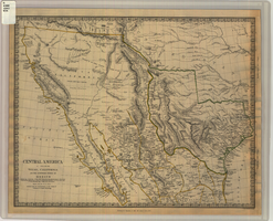
Map of California and territories of New Mexico and Utah, circa 1861
Date
1859 to 1862
Description
'Compiled, drawn, and engraved under the supervision of J.H. Colton and A.J. Johnson.' Relief shown by hachures and spot heights. Scale [ca. 1:3,041,280]. 1 in. to approx. 48 miles (W 124°--W 103°/N 42°--N 31°). Hand coloredPrime meridians: Greenwich and WashingtonPlates 54 & 55 removed from Johnson's New illustrated family atlas of the world, with descriptions geographical, statistical and historical ... New York, 1862Title page of atlas.
Image
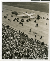
Photograph of Howard Hughes in New York, July 1938
Date
1938-07-14
Archival Collection
Description
A view of crowds waiting to see Howard Hughes arrive at Floyd Bennett Field in New York. Typed onto a piece of paper attached to the image: "Flight's End - Floyd Bennett Field, N.Y. -- Propellers still whirling, the plane which carried Howard Hughes and four companions on their dramatic Round-The-World flight, taxis to a stop, on a runway there, flanked by an escort of motorcycle policemen. Part of the crowd of 30,000 which was on hand to greet the fliers, may be seen. Credit Line (ACME) 7/14/38."
Image
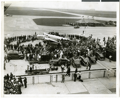
Photograph of crowds at Floyd Bennett Airfield, New York, July 1938
Date
1938-07-14
Archival Collection
Description
The black and white view of Howard Hughes' Lockheed 14 aircraft after performing its final landing on the Round the World flight at Floyd Bennett Airport, New York. Description printed on back of photograph: "General view of welcoming ceremony. 7/14/1938"
Image
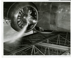
Photograph of Howard Hughes, Bennett Field, New York, July 4, 1938
Date
1938-07-04
Archival Collection
Description
Howard Hughes sitting in an unidentified aircraft in a hangar at Bennett Field, New York.
Image
#65744: Various Campus Scenes - Wright Hall, Beam Hall, Student Union, Barrick Museum, 2007 July 02
Level of Description
File
Archival Collection
University of Nevada, Las Vegas Creative Services Records (2000s)
To request this item in person:
Collection Number: PH-00388-04
Collection Name: University of Nevada, Las Vegas Creative Services Records (2000s)
Box/Folder: N/A
Collection Name: University of Nevada, Las Vegas Creative Services Records (2000s)
Box/Folder: N/A
Archival Component
New Frontier images and videos, 2007 June-July
Level of Description
File
Archival Collection
Barbara Tabach Collection on the New Frontier Hotel and Casino, Las Vegas
To request this item in person:
Collection Number: MS-00800
Collection Name: Barbara Tabach Collection on the New Frontier Hotel and Casino, Las Vegas
Box/Folder: Digital File 00
Collection Name: Barbara Tabach Collection on the New Frontier Hotel and Casino, Las Vegas
Box/Folder: Digital File 00
Archival Component
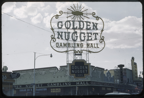
Slide of the Golden Nugget Gambling Hall marquee, Las Vegas, July 1949
Date
1949-07
Archival Collection
Description
A picture of the Golden Nugget Gambling Hall marquee which was on the corner of Fremont and Second Street. This sign was taken down in 1984 when the hotel was going through renovations.
Image
Map of Texas, California, New Mexico and the northern states of Mexico, October 15, 1842
Date
1842-10-15
Description
'Published under the superintendence of the Society for Diffusion of Useful Knowledge.' 'Published by Chapman & Hall, 186 Strand, 15 Oct. 1842.' 'J. & C. Walker, Sculpt.' Scale [ca. 1:7,600,000]. 1 in. to ca. 120 miles (W 125°--W 91°/N 43°--N 23° 30?). 1 map ; 31 x 39 cm. Relief indicated by hachures and spot heights. Shows elevations in yards. Includes notes on exploring expeditions, etc. Borders hand colored. Chapman & Hall.
Image
#71379: Pictures of and from Hospitality Hall, February 15, 2017, 2017 February 15
Level of Description
Item
Archival Collection
University of Nevada, Las Vegas Creative Services Records (2010s)
To request this item in person:
Collection Number: PH-00388-05
Collection Name: University of Nevada, Las Vegas Creative Services Records (2010s)
Box/Folder: Digital File 01
Collection Name: University of Nevada, Las Vegas Creative Services Records (2010s)
Box/Folder: Digital File 01
Archival Component