Search Results
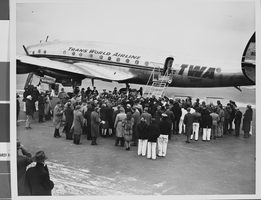
Photograph of Trans World Airline flight, New York, February 15, 1946
Date
1943 to 1945
Archival Collection
Description
Description given with photo: "Non-Stop Los Angeles - New York Flight Inaugurated New York -- View of the crowd around the "Star of California" waiting for passengers -- most of them after it landed at LaGuardia Airport Feb. 15. Piloted by Howard Hughes, famed Around-The-World record holder and a TWA executive, the flight in-augurated non-stop schedule between Los Angeles and New York. The TWA Constellation made the trip in 8 hours and 38 minutes, as compared with the record of 7 hours, 27 minutes. Credit (ACME) 2/15/46."
Image
#64818: New Chair in Artemus W. Ham Concert Hall, 2005 September 08
Level of Description
File
Archival Collection
University of Nevada, Las Vegas Creative Services Records (2000s)
To request this item in person:
Collection Number: PH-00388-04
Collection Name: University of Nevada, Las Vegas Creative Services Records (2000s)
Box/Folder: N/A
Collection Name: University of Nevada, Las Vegas Creative Services Records (2000s)
Box/Folder: N/A
Archival Component
"Las Vegas Town Hall, New Years Resolutions", 1997 January 06
Level of Description
Item
Archival Collection
UNLV TV Audiovisual Collection
To request this item in person:
Collection Number: UA-00098
Collection Name: UNLV TV Audiovisual Collection
Box/Folder: Box 14
Collection Name: UNLV TV Audiovisual Collection
Box/Folder: Box 14
Archival Component
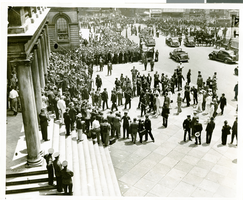
Photograph of a parade for Howard Hughes, New York City, July 15, 1938
Date
1938-07-15
Archival Collection
Description
The black and white view of a parade being held in celebration of Howard Hughes' completion of his Around the World flight in New York City, New York.
Image
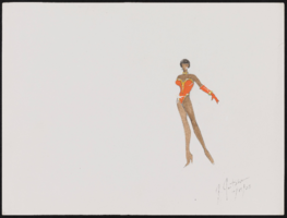
Aretha Franklin at Carnegie Hall, New York: costume design drawings, notes
Date
2003
Archival Collection
Description
Series III. Professional work in the United States: show production materials -- Revues, concerts, and theater production materials
Mixed Content

Map of California and Territories of New Mexico and Utah, 1862
Date
1862
Description
Scale [ca. 1:3,231,360. 1 in. to approx. 51 miles] (W 125°00--W 103°30/N 42°00--N 31°45) ; 1 map : hand col. ; 40 x 60 cm., on sheet 46 x 68 cm ; Relief indicated by hachures and spot heights ; Prime meridians: Greenwich and Washington, D.C ; Decorative border ; Hand colored ; Atlas p. numbers in upper margin: 58-59 ; Date est. from territorial borders and county configuration ; Shows natural features, locations of Indian tribes, proposed railroad routes, routes of explorers, trails, county boundaries and populated places ; Johnson and Ward
Image
#69247: New faculty members on August 15, 2013, 2013 August 15
Level of Description
File
Archival Collection
University of Nevada, Las Vegas Creative Services Records (2010s)
To request this item in person:
Collection Number: PH-00388-05
Collection Name: University of Nevada, Las Vegas Creative Services Records (2010s)
Box/Folder: Digital File 00
Collection Name: University of Nevada, Las Vegas Creative Services Records (2010s)
Box/Folder: Digital File 00
Archival Component
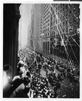
Photograph of a parade procession, New York, July 15, 1938
Date
1938-07-15
Archival Collection
Description
Description printed on photograph's accompanying sheet of paper: "Howard Hughes and crew in parade up Broadway after record-breaking world flight. New York, New York."
Image
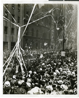
Photograph of a parade procession, New York, July 15, 1938
Date
1938-07-15
Archival Collection
Description
Description printed on photograph's accompanying sheet of paper: "Howard Hughes and crew in parade up Broadway after record-breaking world flight. New York, New York."
Image
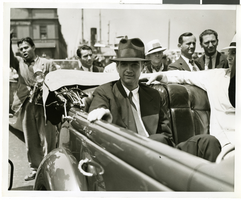
Photograph of Howard Hughes and crew at a parade, New York, July 15, 1938
Date
1938-07-15
Archival Collection
Description
The black and white view of Howard Hughes and his crew at a parade for Howard Hughes after he completed his Around The World flight in New York. Typed onto a piece of paper attached to the image: "Start of parade at battery 7/15/38. (Daily News)."
Image