Search Results
City Swiss Club, annual banquet, menu, at The Monico International Hall, 1902 December 12
Level of Description
Item
Archival Collection
Bohn-Bettoni Menu Collection
To request this item in person:
Collection Number: MS-00793
Collection Name: Bohn-Bettoni Menu Collection
Box/Folder: Box 07
Collection Name: Bohn-Bettoni Menu Collection
Box/Folder: Box 07
Archival Component
North Las Vegas Libriary under construction and City Hall, Civic Center Drive, 1965
Level of Description
File
Archival Collection
North Las Vegas Library Photograph Collection on North Las Vegas, Nevada
To request this item in person:
Collection Number: PH-00277
Collection Name: North Las Vegas Library Photograph Collection on North Las Vegas, Nevada
Box/Folder: Folder 04
Collection Name: North Las Vegas Library Photograph Collection on North Las Vegas, Nevada
Box/Folder: Folder 04
Archival Component
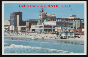
Bally's Park Place, Convention Hall, and other casinos in Atlantic City, New Jersey: postcard
Date
1940 (year approximate) to 1990 (year approximate)
Archival Collection
Description
From Harvey's Hotel and Casino Postcard Collection (PH-00367)
Image
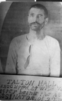
Postcard of Talton Hall, circa 1892
Date
1892
Archival Collection
Description
A protrait of Talton Hall. Beneath the portrait is an inscription: "Talton Hall, executed, at [Wise County, VA] after being the assassinator of [22 m?]"
Image
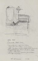
Architectural drawing of Harrah's Marina Hotel Casino (Atlantic City), proposed alterations and rough sketch of the convention hall, July 23, 1982
Date
1982-07-23
Archival Collection
Description
Conceptual sketches of Harrah's Atlantic City. Harrah's Marina Hotel Casino later changed its name to Harrah's Resort Atlantic City. Drawn on tissue paper with pencil.
Site Name: Harrah's Marina Resort (Atlantic City)
Address: 777 Harrah's Boulevard, Atlantic City, NJ
Image
Fishing guides, 1938
Level of Description
File
Archival Collection
Leon Rockwell Papers
To request this item in person:
Collection Number: MS-00013
Collection Name: Leon Rockwell Papers
Box/Folder: Box 01
Collection Name: Leon Rockwell Papers
Box/Folder: Box 01
Archival Component
Brigham Townsend, 1938
Level of Description
File
Archival Collection
Bill Willard Papers
To request this item in person:
Collection Number: MS-00435
Collection Name: Bill Willard Papers
Box/Folder: Box 11
Collection Name: Bill Willard Papers
Box/Folder: Box 11
Archival Component
Correspondence, 1938-1984
Level of Description
File
Archival Collection
Rick L. May Papers
To request this item in person:
Collection Number: MS-00446
Collection Name: Rick L. May Papers
Box/Folder: Box 01
Collection Name: Rick L. May Papers
Box/Folder: Box 01
Archival Component