Search Results
Remarks at dedication of new Post Office in Pahrump, NV., 1967 July 09
Level of Description
File
Archival Collection
Howard Cannon Papers
To request this item in person:
Collection Number: MS-00002
Collection Name: Howard Cannon Papers
Box/Folder: Box 03 (Speeches)
Collection Name: Howard Cannon Papers
Box/Folder: Box 03 (Speeches)
Archival Component
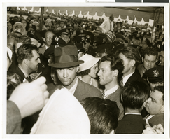
Photograph of Howard Hughes at Floyd Bennett Airfield, New York, July 14, 1938
Date
1938-07-14
Archival Collection
Description
The black and white view of Howard Hughes, surrounded by crowds, after landing his Lockheed 14 aircraft for the Around the World flight at Floyd Bennett Airfield in New York. Description printed on photograph's accompanying sheet of paper: "Howard Hughes at Floyd Bennett Field after his round the world flight, 7-14-38. (Press Association)"
Image
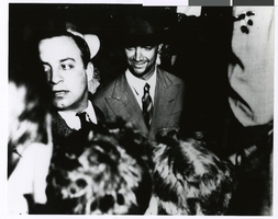
Photograph of Howard Hughes at Floyd Bennett Airfield, New York, July 14, 1938
Date
1938-07-14
Archival Collection
Description
The black and white view of Howard Hughes, surrounded by crowds, after landing his Lockheed 14 aircraft for the Around the World flight at Floyd Bennett Airfield in New York. Description printed on photograph's accompanying sheet of paper: "Howard Hughes at Floyd Bennett Field after completing a round the world flight. 7-14-38 (Press Association)."
Image
[New Hampshire Senatorial Election]. Contains correspondence, resolutions and memos, 1975 July
Level of Description
File
Archival Collection
Howard Cannon Papers
To request this item in person:
Collection Number: MS-00002
Collection Name: Howard Cannon Papers
Box/Folder: Box 02 (Rules/Administration Committee)
Collection Name: Howard Cannon Papers
Box/Folder: Box 02 (Rules/Administration Committee)
Archival Component
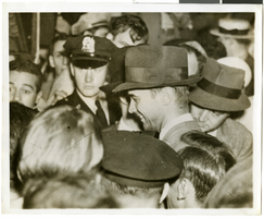
Photograph of Howard Hughes after arriving from his flight around the world, New York, July 13, 1938
Date
1938-07-13
Archival Collection
Description
Howard Hughes (center) in a New York City crowd of people after his around the world flight.
Image
Immigration, Congratulations to New Citizens. Contains correspondence, 1961 July to 1961 October
Level of Description
File
Archival Collection
Howard Cannon Papers
To request this item in person:
Collection Number: MS-00002
Collection Name: Howard Cannon Papers
Box/Folder: Box 11 (87th Session)
Collection Name: Howard Cannon Papers
Box/Folder: Box 11 (87th Session)
Archival Component
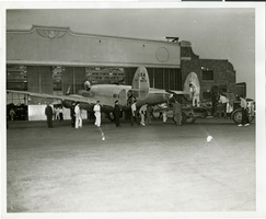
Photograph of people surrounding the Lockheed 14 aircraft, New York, July 9, 1938
Date
1938-07-09
Archival Collection
Description
The black and white view of unidentified people surrounding the Lockheed 14 aircraft. Typed on a piece of paper attached to the image: "Rolling Howard Hughes' plane out of hangar at Floyd Bennett Field, with Lt. Thomas Thurlow, one of the navigators, calibrating the compass. 7/9/38."
Image
Polaroid of Showboat billboard advertising Megabucks, Atlantic City, New Jersey, 1986
Level of Description
Item
Archival Collection
Showboat Atlantic City Photograph Collection
To request this item in person:
Collection Number: PH-00329
Collection Name: Showboat Atlantic City Photograph Collection
Box/Folder: Folder 01
Collection Name: Showboat Atlantic City Photograph Collection
Box/Folder: Folder 01
Archival Component
Gamblers in the Showboat Casino, Atlantic City, New Jersey, black-and-white, 1986
Level of Description
Item
Archival Collection
Showboat Atlantic City Photograph Collection
To request this item in person:
Collection Number: PH-00329
Collection Name: Showboat Atlantic City Photograph Collection
Box/Folder: Folder 01
Collection Name: Showboat Atlantic City Photograph Collection
Box/Folder: Folder 01
Archival Component
Exterior view of Showboat Casino in the evening, Atlantic City, New Jersey, 1986
Level of Description
Item
Archival Collection
Showboat Atlantic City Photograph Collection
To request this item in person:
Collection Number: PH-00329
Collection Name: Showboat Atlantic City Photograph Collection
Box/Folder: Folder 01
Collection Name: Showboat Atlantic City Photograph Collection
Box/Folder: Folder 01
Archival Component