Search the Special Collections and Archives Portal
Search Results
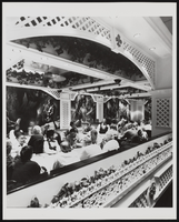
Gamblers in the Showboat Casino, Atlantic City, New Jersey: photographic print
Date
1986
Archival Collection
Description
From the Showboat Atlantic City Photograph Collection (PH-00329).
Image
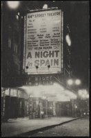
The marquee of the 44th Street Theatre, New York City: photographic print
Date
1890 (year approximate) to 1980 (year approximate)
Archival Collection
Description
The marquee of the 44th Street Theatre, New York City. Grace Hayes' name is on the marquee for the show "A Night in Spain."
Image
Audience reception to screening at WKO Proctor's Theater in New Rochelle, New York, 1951 July 17
Level of Description
File
Archival Collection
Howard Hughes Film Production Records
To request this item in person:
Collection Number: MS-01036
Collection Name: Howard Hughes Film Production Records
Box/Folder: Box 409 (Restrictions apply)
Collection Name: Howard Hughes Film Production Records
Box/Folder: Box 409 (Restrictions apply)
Archival Component
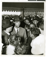
Photograph of Howard Hughes at Floyd Bennett Airfield, New York, July 14, 1938
Date
1938-07-14
Archival Collection
Description
A view of Howard Hughes, surrounded by crowds, after arriving in New York.
Image
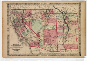
Map of California, Utah, Nevada, Colorado, New Mexico and Arizona, 1864
Date
1864
Description
'Johnson's California, also Utah, Nevada, Colorado, New Mexico, and Arizona, published by A.J. Johnson, New York.' 'Entered according to Act of Congress in the Year 1864, by A.J. Johnson in the Clerks Office of the District Court of the United States for the Southern District of New York.' Atlas page numbers in upper margin: 66-67. Relief shown by hachures. Prime meridians: Greenwich and Washington, D.C. Shows proposed railroads, locations of Indian tribes, natural features, counties, mines, mail routes, trails and routes of exploring expeditions. On verso: History and statistics of Mexico and Central America and statistics of national finances and the Post Office of the United States, 1860. Scale [ca. 1:3,484,800. 1 in. to ca. 55 miles] (W 123°--W 103°/N 42°--N 32°)
Text
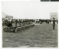
Photograph of the arrival of Howard Hughes' Lockheed 14, New York, July 14, 1938
Date
1938-07-14
Archival Collection
Description
The black and white view of motorcycle police awaiting the arrival of Howard Hughes at Floyd Bennett Field in New York. Typed onto a piece of paper attached to the image: "Motorcycle police on hand for Hughes' landing, New York city -- Motorcycle policemen lined up on Floyd Bennett Field, July 14th, to help keep in check the crowd of 30,000 persons that gathered to greet Howard Hughes and his heroic crew as they landed their giant Lockheed plain after their record-smashing flight around the world. Credit Line (ACME). 7/14/38."
Image
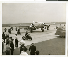
Photograph of Howard Hughes in New York, July 14, 1938
Date
1938-07-14
Archival Collection
Description
Typed onto a piece of paper attached to the image: "Scene at Floyd Bennett Field as Howard Hughes and his crew landed after completing a round the world hop. 7-14-38. (Press Association)."
Image
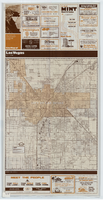
City map of Las Vegas, 1973
Date
1905-05-26
Description
Color; 55 x 45 cm., on sheet 95 x 47 cm., folded to 24 x 10 cm. Panel title: Las Vegas city map. Copyright held by Cardinal Publishing Company. Relief shown by hachures. Includes illustrations and advertisements. Index, text, illustrations, advertisements, and map of "Lake Mead National Recreation Area, lower basin section" on verso. Original publisher: Cardinal Publishing Company.
Image
Grover Whalen and Howard Hughes during a parade that celebrated Hughes's completion of his around-the-world flight in New York City, 1938 July 15
Level of Description
File
Archival Collection
Howard Hughes Public Relations Photograph Collection
To request this item in person:
Collection Number: PH-00373
Collection Name: Howard Hughes Public Relations Photograph Collection
Box/Folder: Folder 12
Collection Name: Howard Hughes Public Relations Photograph Collection
Box/Folder: Folder 12
Archival Component
Pagination
Refine my results
Content Type
Creator or Contributor
Subject
Archival Collection
Digital Project
Resource Type
Year
Material Type
Place
Language
Records Classification
