Search Results
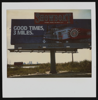
Polaroid of Showboat billboard advertisement, Atlantic City, New Jersey: photographic print
Date
Archival Collection
Description
Image
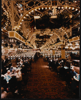
Interior view of Showboat Casino, Atlantic City, New Jersey: photographic print
Date
Archival Collection
Description
Image
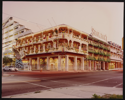
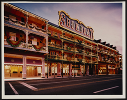
Exterior view of the Showboat Casino, Atlantic City, New Jersey: photographic print
Date
Archival Collection
Description
Image
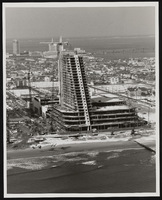
Construction of the Showboat high-rise, Atlantic City, New Jersey: photographic print
Date
Archival Collection
Description
Image
Exterior view of Showboat Casino, Atlantic City, New Jersey: photographic print
Date
Archival Collection
Description
Image
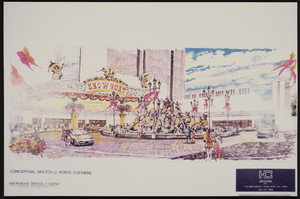
Conceptual sketch of the porte cochere at the Showboat Casino, Atlantic City, New Jersey
Date
Archival Collection
Description
Image

Map of California, Nevada, Utah, Colorado, Arizona & New Mexico, circa 1867
Date
Description
Image

Map of California, and territories of Utah, Nevada, Colorado, New Mexico and Arizona, 1864
Date
Description
Text
New York-New York Hotel and Casino 9-11 Heroes Tribute Collection
Identifier
Abstract
The New York-New York Hotel and Casino 9-11 Heroes Tribute Collection consists of materials from the "Heroes of 9-11" display that was at the New York-New York Hotel and Casino in Las Vegas, Nevada from 2001 to 2012. The materials primarily consist of more than 5,000 t-shirts left at the memorial by visitors to Las Vegas, mostly from fire departments and law enforcement agencies from around the United States. Visitors left shirts and other items at the memorial as a sign of respect for the men and women who died during the terrorist attacks in New York City and Washington, D.C. on September 11, 2001. The collection also houses memorabilia and other items left at the memorial, including flags, hats, pins, buttons, flowers, and embroidered emblems and insignias. The materials also contain documentation of the memorial, including promotional and press materials, video recordings from the news media, photographs, and newspaper articles.
Archival Collection
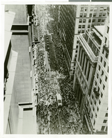
Photograph of a parade for Howard Hughes, New York City, July 15, 1938
Date
Archival Collection
Description
Image