Search Results

Map of Las Vegas and vicinity, Nevada, circa 1957-1961
Date
1957 to 1961
Description
70 x 68 cm. on sheet 106 x 71 cm. Includes indexes. Includes Nellis Air Force Base, Henderson, and inset maps of Boulder City, Nevada, and Las Vegas's geographical location in the Southwest. "H-654-32" on the lower right-hand corner. Page 2 contains a photograph of the Fremont Street in Downtown Las Vegas, featuring the Golden Nugget Gambling Hall and the Horseshoe Casino. Page 3 outlines local and regional attractions, as well as population information. Original publisher: R. L. Polk.
Image
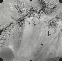
Film transparency of an aerial photo of Boulder City, Nevada, 1974
Date
1974
Archival Collection
Description
An aerial photo of Boulder City, Nevada. The photo was taken in 1974 by Cooper Aerial Surveys, 1692 West Grand Road, Tucson, Arizona 85705, Phone 884-7580.
Image
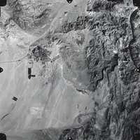
Film transparency of an aerial photo of Boulder City, Nevada, 1974
Date
1974
Archival Collection
Description
An aerial photo of Boulder City, Nevada. The photo was taken in 1974 by Cooper Aerial Surveys, 1692 West Grand Road, Tucson, Arizona 85705, Phone 884-7580.
Image
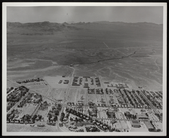
Photograph of an aerial view of Boulder City, Nevada, circa 1930s-1940
Date
1931 to 1940
Archival Collection
Description
Image of an aerial view of Boulder City.
Image
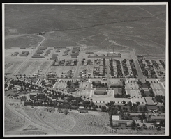
Photograph of an aerial view of Boulder City, Nevada, circa 1931-1940
Date
1931 to 1940
Archival Collection
Description
Image of an aerial view of Boulder City.
Image
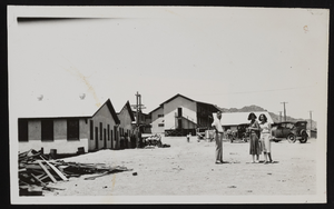
Photograph of workers' camp, Boulder City (Nev.), approximately 1931-1936
Date
1931 to 1936
Archival Collection
Description
A camp for the Hoover Dam workers in Boulder City, Nevada. The building on the left is Anderson's Mess Hall, and the building in the center is a dormitory.
Image
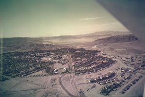
Film transparency of Boulder City, Nevada, circa 1931-1936
Date
1931 to 1936
Archival Collection
Description
An image showing an aerial view of Boulder City. The outlines of the small city are distinctively marked by the stark contrast between the city's greenery and the surrounding desert. In the far distance, the shores of Lake Mead can be seen peaking out from behind the mountains. Note: Bits of the airplane from which the image itself was taken can be seen in the upper right corner of the photograph.
Image
City Center Motel, 1986
Level of Description
File
Archival Collection
Neon in Nevada Photograph Collection
To request this item in person:
Collection Number: PH-00225
Collection Name: Neon in Nevada Photograph Collection
Box/Folder: Binder PB-005
Collection Name: Neon in Nevada Photograph Collection
Box/Folder: Binder PB-005
Archival Component
Golden City Motel, 1986
Level of Description
File
Archival Collection
Neon in Nevada Photograph Collection
To request this item in person:
Collection Number: PH-00225
Collection Name: Neon in Nevada Photograph Collection
Box/Folder: Binder PB-005
Collection Name: Neon in Nevada Photograph Collection
Box/Folder: Binder PB-005
Archival Component
City Center Motel, 1986
Level of Description
File
Archival Collection
Neon in Nevada Photograph Collection
To request this item in person:
Collection Number: PH-00225
Collection Name: Neon in Nevada Photograph Collection
Box/Folder: Binder PB-005
Collection Name: Neon in Nevada Photograph Collection
Box/Folder: Binder PB-005
Archival Component