Search Results
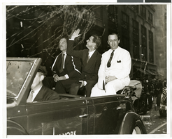
Photograph of a parade procession for Howard Hughes, New York, July 15, 1938
Date
1938-07-15
Archival Collection
Description
Picture of Grover Whalen, Howard Hughes, and Al Lodwick riding in the back of an automobile during a parade celebrating Howard Hughes' completion of his round-the-world flight.
Image
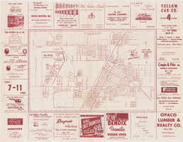
Map of the city of Las Vegas, 1953
Date
1953
Description
24 x 38 cm. on sheet 43 x 56 cm., folded to 28 x 13 cm. Includes advertisements for Las Vegas businesses. Advertisements for Las Vegas businesses, inset map of North Las Vegas, and index on verso. Copyright held by Redwood Pub. Co. Includes inset map of the Strip (U.S. 91 or Los Angeles Highway). Map is irregularly shaped. Original publisher: Redwood Pub. Co..
Image
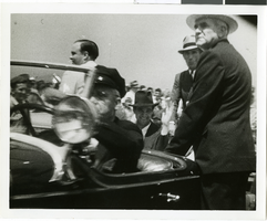
Photograph of Howard Hughes and crew at a parade, New York, July 15, 1938
Date
1938-07-15
Archival Collection
Description
The black and white view of Howard Hughes and his crew at a parade for Howard Hughes after he completed his Around The World flight in New York.
Image
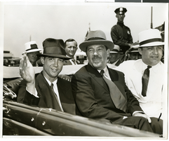
Photograph of Howard Hughes and crew at a parade, New York, July 15, 1938
Date
1938-07-15
Archival Collection
Description
The black and white view of Howard Hughes and his crew at a parade for Howard Hughes after he completed his Around The World flight in New York.
Image
Proposed Hotel, Atlantic City Convention Center: Atlantic City, New Jersey, 1976 November 22
Level of Description
Series
Archival Collection
Martin Stern Architectural Records
To request this item in person:
Collection Number: MS-00382
Collection Name: Martin Stern Architectural Records
Box/Folder: N/A
Collection Name: Martin Stern Architectural Records
Box/Folder: N/A
Archival Component

Map of California, Utah, Nevada, Colorado, New Mexico and Arizona, circa 1867
Date
1865 to 1869
Description
39 x 56 cm. Relief shown by hachures. "Entered according to act of Congress in the year 1864, by A.J. Johnson in the Clerks Office of the United States for the Southern District of New York." Atlas page numbers in upper margin: 67-68. Primer meridians: Greenwich and Washington, D.C. On verso: History and statistical view of the West India islands or Columbian Archipelago and Historical and statistical view of Mexico and Central America. Shows proposed railroads, locations of Indian tribes, natural features, counties, mines, mail routes, trails and routes of exploring expeditions. Has decorative border. Southern part of Nevada was added to the state in 1867 and is part of Nevada on this map, but Lincoln County was established in 1867 and is not on this map. This map was still probably published in 1867 in spite of someone's having written "1864" in pencil in the lower right corner of the Library's copy. Original publisher: A.J. Johnson.
Image
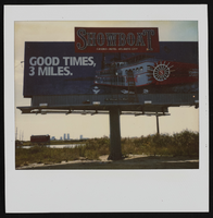
Polaroid of Showboat billboard advertisement, Atlantic City, New Jersey: photographic print
Date
1986
Archival Collection
Description
From the Showboat Atlantic City Photograph Collection (PH-00329).
Image
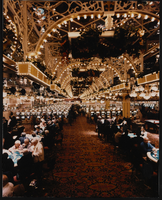
Interior view of Showboat Casino, Atlantic City, New Jersey: photographic print
Date
1986
Archival Collection
Description
From the Showboat Atlantic City Photograph Collection (PH-00329).
Image
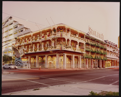
Exterior view of the Showboat Casino, Atlantic City, New Jersey: photographic print
Date
1986
Archival Collection
Description
From the Showboat Atlantic City Photograph Collection (PH-00329).
Image
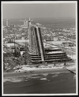
Construction of the Showboat high-rise, Atlantic City, New Jersey: photographic print
Date
1986
Archival Collection
Description
From the Showboat Atlantic City Photograph Collection (PH-00329).
Image