Search Results
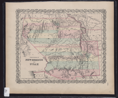
Map showing the territories of New Mexico and Utah, 1855
Date
1855
Description
'Entered according to Act of Congress in the year 1855 by J.H. Colton & Co. in the Clerk's Office of the Dist. Court of the U.S. for the South'n. Dist. of New York.' Scale [ca. 1:4,752,000. 1 in. to approx. 75 miles] (W 120°--W 102°/N 43°--N 32°). Shows natural features, and populated places, wagon route, proposed railroad routes and explorers' routes. Relief shown by hachures. Prime meridians: Greenwich and Washington.Hand colored. Atlas p. number in lower-right margin: 51. Decorative border. J.H. Colton & Co.
Image
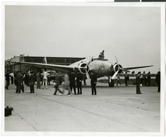
Photograph of the Lockheed 14 aircraft, New York, New York, July 9, 1938
Date
1938-07-09
Archival Collection
Description
The black and white view of the Lockheed 14 aircraft in New York, New York. Typed on a piece of paper attached to the image: "Readying Hughes' plane for Paris flight. Hughes's Lockheed 14 monoplane in shape for a flight from Floyd Bennett Airport here, to Paris. Motor trouble forced postponement and helpers were working under injunction to have the ship ready for a takeoff July 9 "at the earliest possible moment." Photo shows: General view of crowd watching plane being serviced outside hangar. Credit Line (ACME) 7/9/1938."
Image
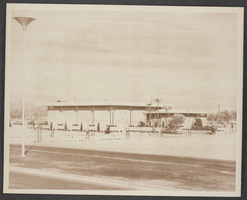
Photograph of the exterior of North Las Vegas City Hall, circa late 1960s
Date
1967 to 1969
Archival Collection
Description
A picture of the North Las Vegas City Hall from a distance.
Image
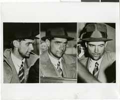
Photograph of Howard Hughes in New York, July 1938
Date
1938-07-14
Archival Collection
Description
Multiple, close up views of Howard Hughes in the back of an automobile in New York. Typed onto a piece of paper attached to the image: "Howard Hughes at Floyd Bennett Airport being interviewed after his record-breaking flight around the world. 7/14/38."
Image
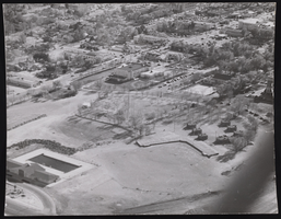
Photograph of an aerial view of Squires Park and City Hall, Las Vegas (Nev.), 1934-1952
Date
1934 to 1952
Archival Collection
Description
An aerial view of Las Vegas-Squires park & City Hall-Dula Memorial Center (left front) before City Library & new State Building.
Image

Map of California and territories of New Mexico and Utah, circa 1861
Date
1856 to 1866
Description
40 x 60 cm. Relief shown by hachures and spot heights. Prime meridians: Greenwich and Washington. Atlas plate numbers 54 and 55 in the upper corners. Shows forts, trails, exploration routes, drainage, mail steamship routes, physical features, Indian tribes, and historic sites. The geographic region of Southwest is referred to as the New Southwest. Original publisher: Johnson .
Image
#63528: Hall, Gene (Dean), 2002 July 23
Level of Description
File
Archival Collection
University of Nevada, Las Vegas Creative Services Records (2000s)
To request this item in person:
Collection Number: PH-00388-04
Collection Name: University of Nevada, Las Vegas Creative Services Records (2000s)
Box/Folder: N/A
Collection Name: University of Nevada, Las Vegas Creative Services Records (2000s)
Box/Folder: N/A
Archival Component
Dedication of the Beatty Fire Hall, 1960 July 04
Level of Description
File
Archival Collection
Nye County, Nevada Photograph Collection
To request this item in person:
Collection Number: PH-00221
Collection Name: Nye County, Nevada Photograph Collection
Box/Folder: Folder 07
Collection Name: Nye County, Nevada Photograph Collection
Box/Folder: Folder 07
Archival Component