Search Results

Map of California and territories of New Mexico and Utah, circa 1861
Date
1859 to 1862
Description
'Compiled, drawn, and engraved under the supervision of J.H. Colton and A.J. Johnson.' Relief shown by hachures and spot heights. Scale [ca. 1:3,041,280]. 1 in. to approx. 48 miles (W 124°--W 103°/N 42°--N 31°). Hand colored
Prime meridians: Greenwich and Washington
Plates 54 & 55 removed from Johnson's New illustrated family atlas of the world, with descriptions geographical, statistical and historical ... New York, 1862
Title page of atlas.
Prime meridians: Greenwich and Washington
Plates 54 & 55 removed from Johnson's New illustrated family atlas of the world, with descriptions geographical, statistical and historical ... New York, 1862
Title page of atlas.
Image
Virginia City, Nevada, undated
Level of Description
File
Archival Collection
Nevada Mining Photograph Collection
To request this item in person:
Collection Number: PH-00361
Collection Name: Nevada Mining Photograph Collection
Box/Folder: Folder 10 (Restrictions apply)
Collection Name: Nevada Mining Photograph Collection
Box/Folder: Folder 10 (Restrictions apply)
Archival Component
Boulder City map, 1977
Level of Description
File
Archival Collection
Elmo C. Bruner Architectural and Real Estate Appraisal Records
To request this item in person:
Collection Number: MS-00177
Collection Name: Elmo C. Bruner Architectural and Real Estate Appraisal Records
Box/Folder: Flat File 77
Collection Name: Elmo C. Bruner Architectural and Real Estate Appraisal Records
Box/Folder: Flat File 77
Archival Component
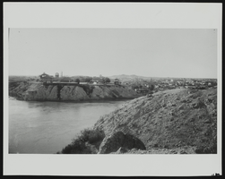
View of Yuma City, Arizona: photographic print
Date
1870 (year approximate) to 1979 (year approximate)
Archival Collection
Description
From the KLVX Steamboats on the Colorado Photograph Collection (PH-00156). "COPY 25328 Reproduction from the Original in the Arizona Historical Society" stamp on verso.
Image
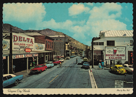
Virginia City, Nevada: postcard
Date
1940 (year approximate) to 1990 (year approximate)
Archival Collection
Description
From the Harvey's Hotel and Casino Postcard Collection (PH-00367) -- The Delta Saloon & Café and the Bucket of Blood Saloon are pictured.
Image
Oklahoma City Conference, 1999
Level of Description
File
Archival Collection
Marie and James B. McMillan Papers
To request this item in person:
Collection Number: MS-00482
Collection Name: Marie and James B. McMillan Papers
Box/Folder: Box 08
Collection Name: Marie and James B. McMillan Papers
Box/Folder: Box 08
Archival Component
City Council Agenda, 1984
Level of Description
File
Archival Collection
Marie and James B. McMillan Papers
To request this item in person:
Collection Number: MS-00482
Collection Name: Marie and James B. McMillan Papers
Box/Folder: Box 17
Collection Name: Marie and James B. McMillan Papers
Box/Folder: Box 17
Archival Component
City Park, 1928-1949
Level of Description
File
Archival Collection
Union Pacific Railroad Collection
To request this item in person:
Collection Number: MS-00397
Collection Name: Union Pacific Railroad Collection
Box/Folder: Box 03
Collection Name: Union Pacific Railroad Collection
Box/Folder: Box 03
Archival Component
Conveyance to City of Whittier, 1917
Level of Description
File
Archival Collection
Union Pacific Railroad Collection
To request this item in person:
Collection Number: MS-00397
Collection Name: Union Pacific Railroad Collection
Box/Folder: Box 125
Collection Name: Union Pacific Railroad Collection
Box/Folder: Box 125
Archival Component
Skit Trip 8: "Big City"
Level of Description
File
Archival Collection
Guide to the Canadian Film Centre Worldwide Short Film Festival Submissions
To request this item in person:
Collection Number: MS-00615
Collection Name: Guide to the Canadian Film Centre Worldwide Short Film Festival Submissions
Box/Folder: Box 2006-011
Collection Name: Guide to the Canadian Film Centre Worldwide Short Film Festival Submissions
Box/Folder: Box 2006-011
Archival Component