Search Results
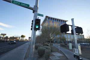
Exterior view of the North Las Vegas City Hall building, looking east in North Las Vegas, Nevada: digital photograph
Date
2019-02-06
Archival Collection
Description
From the UNLV University Libraries Photographs of the Development of the Las Vegas Valley, Nevada (PH-00394). Part of the collection documents the entire 19 mile length of the north/south Eastern Avenue / Civic Center Drive alignment. This photograph was captured in the section of Civic Center Drive between Las Vegas Boulevard and Lake Mead Boulevard.
Image
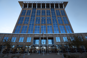
Exterior view of the North Las Vegas City Hall building, looking southeast in North Las Vegas, Nevada: digital photograph
Date
2019-02-06
Archival Collection
Description
From the UNLV University Libraries Photographs of the Development of the Las Vegas Valley, Nevada (PH-00394). Part of the collection documents the entire 19 mile length of the north/south Eastern Avenue / Civic Center Drive alignment. This photograph was captured in the section of Civic Center Drive between Las Vegas Boulevard and Lake Mead Boulevard.
Image
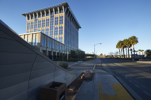
Exterior view of the North Las Vegas City Hall building, looking west in North Las Vegas, Nevada: digital photograph
Date
2019-02-06
Archival Collection
Description
From the UNLV University Libraries Photographs of the Development of the Las Vegas Valley, Nevada (PH-00394). Part of the collection documents the entire 19 mile length of the north/south Eastern Avenue / Civic Center Drive alignment. This photograph was captured in the section of Civic Center Drive between Las Vegas Boulevard and Lake Mead Boulevard.
Image
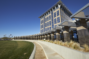
Exterior view of the North Las Vegas City Hall building, looking west in North Las Vegas, Nevada: digital photograph
Date
2019-02-06
Archival Collection
Description
From the UNLV University Libraries Photographs of the Development of the Las Vegas Valley, Nevada (PH-00394). Part of the collection documents the entire 19 mile length of the north/south Eastern Avenue / Civic Center Drive alignment. This photograph was captured in the section of Civic Center Drive between Las Vegas Boulevard and Lake Mead Boulevard.
Image
Newspaper clippings on city planning and zoning, 1966 June to 1968 July
Level of Description
File
Archival Collection
Ardis Kearns Papers
To request this item in person:
Collection Number: MS-00348
Collection Name: Ardis Kearns Papers
Box/Folder: Box 06
Collection Name: Ardis Kearns Papers
Box/Folder: Box 06
Archival Component
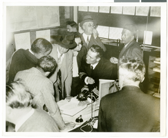
Photograph of Howard Hughes, Le Bourget, France, July 1938
Date
1938-07
Archival Collection
Description
Description printed on accompanying strip of paper: "Howard Hughes reading maps and studying his way in the meteorological office at the Le Bourget. July 1938"
Image
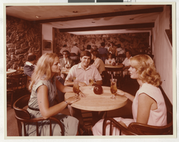
Photograph of people in the Boulder City Hotel, Boulder City (Nev.), 1970s
Date
1970 to 1979
Archival Collection
Description
Group of people drinking in the remodeled Boulder City Hotel, Boulder City, 1970s.
Image