Search Results
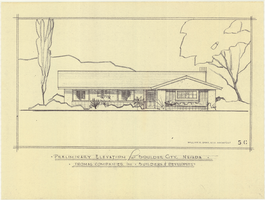
Architectural drawing of residential home in Boulder City, Nevada, preliminary elevation, 1962
Date
Archival Collection
Description
Preliminary drawing of front exterior elevation of a ranch-style residential home in Boulder City, Nevada.
Architecture Period: Mid-Century ModernistImage
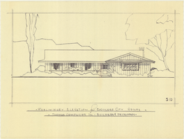
Architectural drawing of residential home in Boulder City, Nevada, preliminary elevation, 1962
Date
Archival Collection
Description
Preliminary drawing of front exterior elevation of a ranch-style residential home in Boulder City, Nevada.
Architecture Period: Mid-Century ModernistImage
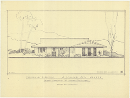
Architectural drawing of residential home in Boulder City, Nevada, preliminary elevation, 1962
Date
Archival Collection
Description
Preliminary drawing of front exterior elevation of a ranch-style residential home in Boulder City, Nevada.
Architecture Period: Mid-Century ModernistImage
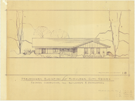
Architectural drawing of residential home in Boulder City, Nevada, preliminary elevation, 1962
Date
Archival Collection
Description
Preliminary drawing of front exterior elevation of a ranch-style residential home in Boulder City, Nevada.
Architecture Period: Mid-Century ModernistImage
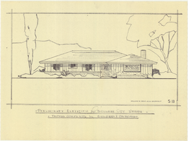
Architectural drawing of residential home in Boulder City, Nevada, preliminary elevation, 1962
Date
Archival Collection
Description
Preliminary drawing of front exterior elevation of a ranch-style residential home in Boulder City, Nevada.
Architecture Period: Mid-Century ModernistImage
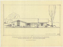
Architectural drawing of residential home in Boulder City, Nevada, preliminary elevation, 1962
Date
Archival Collection
Description
Preliminary drawing of front exterior elevation of a ranch-style residential home in Boulder City, Nevada.
Architecture Period: Mid-Century ModernistImage
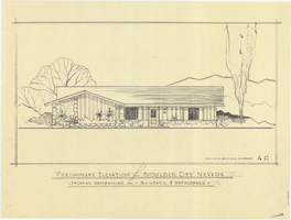
Architectural drawing of residential home in Boulder City, Nevada, preliminary elevation, September 19, 1962
Date
Archival Collection
Description
Preliminary drawing of front exterior elevation of a ranch-style residential home in Boulder City, Nevada.
Architecture Period: Mid-Century ModernistImage
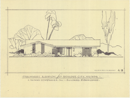
Architectural drawing of residential home in Boulder City, Nevada, preliminary elevation, 1962
Date
Archival Collection
Description
Preliminary drawing of front exterior elevation of ra anch-style residential home in Boulder City, Nevada. Handwritten near lower right: "Elevations only for Plan 1 (1B, 1C, 1D), Plan 2 (2B, 2C, 2D), Plan 4 (4B, 4C, 4D), Plan 5 (5B, 5C, 5D)."
Architecture Period: Mid-Century ModernistImage
Boulder City, Nevada Financial Reports and Budgets
Identifier
Abstract
Collection is comprised of annual budgets, financial statements, and auditor's reports dating from 1976 to 1989 created for the city of Boulder City, Nevada and adopted by the City Council.
Archival Collection

Plat of H.F.M & M addition to city of Las Vegas, Clark County, Nevada, comprising the west 1/2 of N.W. 1/4 Sec. 27, Twp. 20 S., R. 61 E., M.D.B & M, March 8, 1924
Date
Description
Image