Search Results
Aviation, LV Hacienda vs. CAB. Contains correspondence, memos and reports, 1961 April to 1962 September
Level of Description
Archival Collection
Collection Name: Howard Cannon Papers
Box/Folder: Box 03 (87th Session)
Archival Component
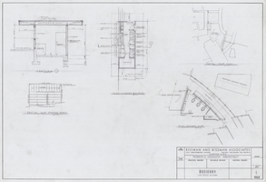
Architectural drawing of the Hacienda (Las Vegas), second room and public area additions, barbershop, cabana, sections, and partial plot plan, February 28, 1964
Date
Archival Collection
Description
Barbershop, cabana, sections, and partial plot plan for a remodel of the Hacienda from 1964.
Site Name: Hacienda
Address: 3590 Las Vegas Boulevard South
Image
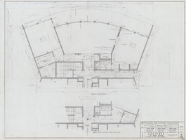
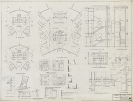
Architectural drawing of the Hacienda (Las Vegas), typical unit plans, rooms 701-702, 717-718, and 733-734, March 25, 1963
Date
Archival Collection
Description
Plans for hotel room and public area additions for the Hacienda from 1963-1965. J. L. Cusick and Associates, electrical engineers; Harold L. Epstein and Associates, structural engineers; W. L. Donley and Associates, mechanical engineers.
Site Name: Hacienda
Address: 3590 Las Vegas Boulevard South
Image
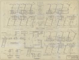
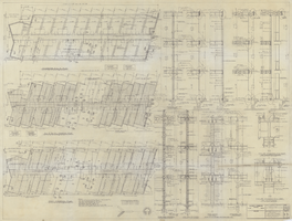
Architectural drawing of the Hacienda (Las Vegas), detailed plans, units of 900 Wing, 800 Wing similar but opposite hand, jamb details, August 5, 1957
Date
Archival Collection
Description
Plans for the construction of a 266 room addition for the Hacienda.
Site Name: Hacienda
Address: 3590 Las Vegas Boulevard South
Image
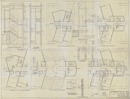
Architectural drawing of the Hacienda (Las Vegas), detailed plans, end stairs of 700 and 900 Wings and typical stair sections details, August 5, 1957
Date
Archival Collection
Description
Plans for the construction of a 266 room addition for the Hacienda. 'Prelim. ozalid 7-25-57, detailed plans, end stairs of 700 and 900 wings'--lower right corner.
Site Name: Hacienda
Address: 3590 Las Vegas Boulevard South
Image
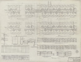
Architectural drawing of the Hacienda (Las Vegas), framing and foundations 900 Wing, 800 Wing similar but opposite hand, wall sections, August 5, 1957
Date
Archival Collection
Description
Plans for the construction of a 266 room addition for the Hacienda. Includes foundation and first floor plan, second and third floor framing plan, roof framing plan, interior and fire wall details.
Site Name: Hacienda
Address: 3590 Las Vegas Boulevard South
Image
Architectural drawing of the Hacienda (Las Vegas), revised elevator lobby plans, stair details, fireman's auxiliary scuttle and employee toilet elevations, circa September 1957
Date
Archival Collection
Description
Plans for the construction of a 266 room addition for the Hacienda.
Site Name: Hacienda
Address: 3590 Las Vegas Boulevard South
Image
Architectural drawing of the Hacienda (Las Vegas), golf course, plans and elevations, room and door schedule, exterior eave and spandrel and sash detail, December 4, 1957
Date
Archival Collection
Description
Plans for the golf course additions for the Hacienda from 1957-58. 'C.' Includes door jamb details and closet details.
Site Name: Hacienda
Address: 3590 Las Vegas Boulevard South
Image
Intersection of Hacienda and Eastern Avenues, looking north in Las Vegas, Nevada: digital photograph, 2019 March 13
Level of Description
Archival Collection
Collection Name: UNLV University Libraries Photographs of the Development of the Las Vegas Valley, Nevada
Box/Folder: N/A
Archival Component
Additions to Las Vegas Hacienda: architectural drawings, sheets 1-18, 1956 April 13; 1956 July 20
Level of Description
Archival Collection
Collection Name: Homer Rissman Architectural Records
Box/Folder: Flat File 167
Archival Component