Search Results
General geological papers, approximately 1919 to 1951
Level of Description
Scope and Contents
The Franklin M. Murphy General Geological Papers (1919-1951) contain university grades, thesis, and other papers written by Murphy. Also included are proposals, correspondence, newspaper clippings, maps, notes, and geological findings relating to mining and water.
Archival Collection
Collection Name: Franklin M. Murphy Geological Papers
Box/Folder: N/A
Archival Component
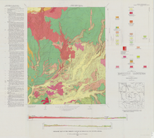
Geologic map of the Thirsty Canyon quadrangle, Nye County, Nevada, 1966
Date
Description
Image
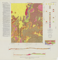
Geologic map of the Quartet Dome quadrangle, Nye County, Nevada, 1966
Date
Description
Image

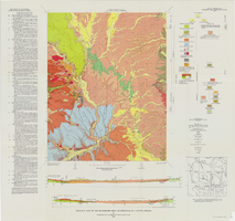
Geologic map of the Topopah Spring quadrangle, Nye County, Nevada, 1970
Date
Description
Image
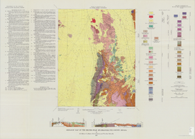
Geologic map of the Buckboard Mesa quadrangle, Nye County, Nevada, 1966
Date
Description
Image
Series I. Geological field notes, 1919 to 1971
Level of Description
Scope and Contents
The geological field notes series (1919-1971) consists of observations, sketches, and measurements taken by Chester Longwell on geological field trips, primarily in southern Nevada but also throughout the United States, the United Kingdom, South Africa, and Australia.
Archival Collection
Collection Name: Chester R. Longwell Professional Papers
Box/Folder: N/A
Archival Component
Geologic map of the Belted Peak quadrangle, Nye County, Nevada, 1967
Date
Description
Image

Geologic map of the Tippipah Spring quadrangle, Nye County, Nevada, 1963
Date
Description
Image
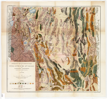
Geological reconnaissance map of Nevada south of the 40th parallel and adjacent California, 1903
Date
Description
Image

Geologic map of the Dead Horse Flat quadrangle, Nye County, Nevada, 1967
Date
Description
Image