Search Results
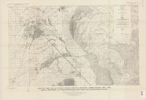
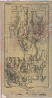
Map of part of Las Vegas Valley, Nevada, showing approximate area and areal densities of phreatophytes and areas in cultivation in 1912
Date
1965
Description
Genre/Form: Thematic maps. Scale 1:62,500 (W 115°15´--W 114°45´/N 36°15´--N 36°00´). 1 map : col. ; 45 x 72 cm. Series: Water-supply paper (Washington, D.C.) ; 1780. Relief shown by contours. Originally published as plate 11 of Available water supply of the Las Vegas ground-water basin, Nevada, by Glenn T. Malmberg, published by the Geological Survey in 1965 as its Water-supply paper 1780. Includes township and range lines. Interior, Geological Survey
Image
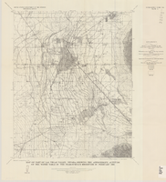
Map of part of Las Vegas Valley, Nevada, showing the approximate altitude of the water table in the near-surface reservoir in February 1956
Date
1965
Description
Genre/Form: Thematic maps. Scale 1:62,500 (W 115°15´--W 115°00´/N 36°15´--N 36°00´). 1 map ; 45 x 36 cm. Series: Water-supply paper (Washington, D.C.) ; 1780. Relief shown by contours. Originally published as plate 8 of Available water supply of the Las Vegas ground-water basin, Nevada, by Glenn T. Malmberg, published by the Geological Survey in 1965 as its Water-supply paper 1780. Includes township and range lines. Interior, Geological Survey
Image
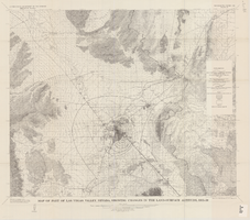
Map of part of Las Vegas Valley, Nevada, showing changes in the land-surface altitude, 1935-50
Date
1965
Description
Genre/Form: Topographic maps. Scale 1:96,000 (W 115°30´--W 114°45´/N 36°30´--N 36°00´). 1 map ; 58 x 70 cm. Series: Water-supply paper (Washington, D.C.) ; 1780. Relief shown by contours. "After Smith, Vetter, Cummings, and others (1960, p. 34)." Originally published as plate 13 of Available water supply of the Las Vegas ground-water basin, Nevada, by Glenn T. Malmberg, published by the Geological Survey in 1965 as its Water-supply paper 1780. Includes township and range lines. Interior, Geological Survey
Image
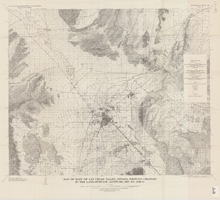
Map of part of Las Vegas Valley, Nevada, showing changes in the land-surface altitude, 1935 to 1940-41
Date
1965
Description
Genre/Form: Topographic map. Scale 1:96,000 (W 115°30´--W 114°45´/N 36°30´--N 36°00´). 1 map ; 58 x 70 cm. Series: Water-supply paper (Washington, D.C.) ; 1780. Relief shown by contours. "After C.R. Longwell (written communication, 1954, fig. 30)." Originally published as plate 12 of Available water supply of the Las Vegas ground-water basin, Nevada, by Glenn T. Malmberg, published by the Geological Survey in 1965 as its Water-supply paper 1780. Includes township and range lines. Interior, Geological Survey
Image
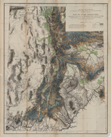
Map of Utah territory representing the extent of the irrigable, timber and pasture lands, 1878
Date
1878
Description
90 x 71 cm. Relief shown by hachures. In bottom margin: "Julius Bien, Lith." "Note. This map has been constructed from atlas sheets of the U.S. Geographical and Geological Survey of the Rocky Mountain Region with additional material taken from the maps of the U.S. Geographical Explorations and Surveys west of the 100th meridian, Lieut. Geo. M. Wheeler, Corps of Engineers, in charge ; the U.S. Geological Exploration of the 40th parallel, Clarence King, U.S. Geologist in charge ; and the U.S. Geologial and Geographical Survey of the Territories, F.V. Hayden, in charge." At head of title: Department of the Interior, U.S. Geographical and Geological Survey of the Rocky Mountain region, J.W. Powell in charge. Original publisher unknown.
Image
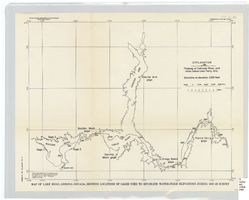
Map of Lake Mead, Arizona-Nevada, showing locations of gages used to establish water-stage elevations during 1947-49 survey
Date
1960
Description
Scale [ca. 1:274,349. 1 in. to approx. 4.33 miles] (W 114°54?--W 113°54?/N 36°36?--N 35°58?). 1 map ; 27 x 34 cm. United States Dept. of the Interior, Geological Survey
Image
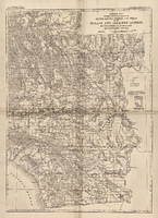
General map showing approximate location of better known springs and wells in the Mohave and adjacent deserts, southeastern California and southwestern Nevada, circa 1908-1909
Date
1905 to 1912
Description
At top of map: 'U.S. Geological Survey, George Otis Smith, Director. Water-supply paper no. 224, pl. 1.' 'Topography compiled from U.S. Geographical Survey atlas sheets,Perris' map of Southern California and other sources.' Relief shown by hachures. Shows township and range grid. Covers the area from Bishop south to the Mexican border, from Long Beach and San Diego to the Arizona border, and the southern part of Nevada, from Beatty and Mesquite south. Scale [ca. 1:1,140,480. 1 in. to approx. 18 miles] (W 118°00´- -W 114°00´/N 37°00´--N 32°32´). Series: Water-supply paper (Washington, D.C.)224. Map is plate 1 from the U.S. Geological Survey Water-supply paper 224.
Image
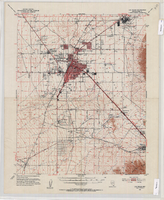
Topographic map of the Las Vegas Valley Area, 1952
Date
1952
Description
Scale 1:62,500 ; polyconic proj ; 1 map : col. ; 45 x 36 cm.; Relief shown by contours and spot heights. Contour interval 20 ft. ; Includes quadrangle location map ; Nevada 15 minute series (topographic) ; Fifteen minute series (topographic) Nevada ; Geological Survey
Image
Map of a part of southern Nevada showing ground-water conditions, 1914
Date
1914
Description
At bottom of map: 'Base compiled from plane-table sheets, topographic maps of U.S. Geological Survey, railroad alignments, and General Land Office data.' Relief shown by hachures and spot heights. Shows township and range grid. Covers from southeast corner of White Pine County to Sloan and from Nye County border to Arizona-Utah border. Shows flowing wells, nonflowing wells, springs, flowing-well areas, dry holes and shore lines of ancient lakes. Scale 1:500,000 (W116°--W 114°/N 45°--N 36°). Series: Water-supply paper (Washington, D.C.), 365. Map is plate 1 from the U.S. Geological Survey water-supply paper 365.
Image
Topographic map of Arrow Canyon dam and reservoir site on the Muddy River, 1934
Date
1934
Archival Collection
Description
'Topography by Lee Morrison. Control by U.S. Geological Survey and U.S. Bureau of Reclamation. Surveyed in 1934.' Relief shown by contours and spot heights. 'Arrowhead Canyon Dam and reservoir site' hand-written on map. Map is part of a larger map and has been taped to a manila envelope sent from the Agricultural Administration to J.H. Wittwer on Sept. 25, 1939. Map has hand-drawn township and range lines and handwritten numbers. Verso has a hand-drawn map, calculations, and hand-written notes. U.S. Geological Survey
Text