Search Results

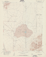
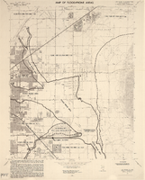
Topographic map of Cane Spring, Nevada quadrangle, 1961
Date
1961
Description
'Mapped, edited and published by the Geological Survey in cooperation with the Atomic Enegry Commission. Control by USGS, USC&GS, USCE, and Atomic Energy Commission. Topography from aerial photographs by photogrammetric methods. Aerial photographs taken 1959. Field check 1961.' Scale 1:24,000 polyconic projection (W 116°07'30"--W 116°00'00"/N 36°52'30"--N 36°45'00"). Series: 7.5 minute series (topographic). Relief shown by contours and spot heights. Contour interval 20 feet. Includes quadrangle location map. Interior--Geological SurveyFor sale by the U.S. Geological Survey
Image
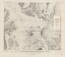
Topographic map of Frenchman Flat quadrangle, Nevada, 1960
Date
1960
Description
'Mapped, edited, and published by the Geological Survery in cooperation with the Atomic Energy Commission. Control by USGS, USC&GS, USCE, and Atomic Energy Commission. Topography from aerial photographs by photogrammetric methods. Aerial photographs taken 1959. Field check 1960.' Scale 1:24,000 polyconic projection (W 116°00'00"--W 115°52'30"/N 36°52'30"--N 36°45'00"). Series: 7.5 minute series (topographic). Relief shown by contours and spot heights. Filing title: Frenchman Flat, Nev. Contour interval 20 feet. opography rom . Includes quadrangle location map. Interior--Geological SurveyFor sale by the U.S. Geological Survey
Image
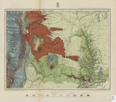
Map of part of north central New Mexico, atlas sheet no. 70(C), May 7th, 1877
Date
1877-05-07
Description
39 x 50 cm. Relief shown by hachures and spot heights. "Issued May 7th 1877-2nd ed. June 30th, 1881." "Expeditions of 1878 and 1879 under the command of 1st. Lieut. Geo. M. Wheeler, Corp. of Engineers U.S. Army." "Weyss Herman & Lang Del." Prime meridians: Washington, D.C. and Greenwich Geological map Probably originally published as part of the geological atlas which is an appendix to the Surveys' Report upon United States geographical surveys west of the one hundredth meridian. "Prof. John J. Stevenson, geological assistant." "By order of the honorable the Secretary of War under the direction of Brig. General A. A. Hunphreys, Chief of Engineers, U. S. Army." Original publisher: U.S. Geographical Surveys West of the 100th Meridian, Scale: 1 inch to 4 miles or 1: 253440.
Image
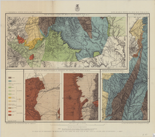
Map of part of North Central New Mexico atlas sheets 69(B), 69(D), 77(B) and 78(A), June 30, 1881
Date
1881-06-30
Description
39 x 52 cm. Relief shown by hachures and spot heights "Issued June 30, 1881." "Expeditions of 1873, 1878 and 1879 under the command of 1st. Lieut. Geo. M. Wheeler, Corps of Engineers U.S. Army." Geological map Probably originally published as part of the geological atlas which is an appendix to the Surveys' Report upon United States geographical surveys west of the one hundredth meridian. "Prof. John J. Stevenson, geological assistant." "By order of the honorable the Secretary of War under the direction of Brig. General A. A. Hunphreys, Chief of Engineers, U. S. Army." Original publisher: U.S. Geographical Surveys West of the 100th Meridian, Scale: 1 inch to 4 miles or 1: 253440.
Image
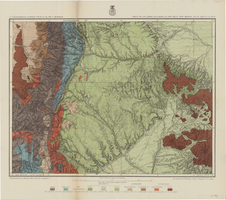
Map of parts of southern Colorado and northern New Mexico, atlas sheet no. 70(A), 1877
Date
1877-05-07
Description
37 x 50 cm. Prime meridian: Washington, D.C. Relief shown by hachures and spot heights. "Issued May 7th, 1877. 2nd ed., June 30th, 1881." "Atlas sheet no. 77(B)." "Expeditions of 1871 & 1786 under the command of 1st. Lieut. Geo. M. Wheeler, Corps of Engineers, U.S. Army." "Weyss, Herman & Lang, del." Probably originally published as part of the geological atlas which is an appendix to the Surveys' Report upon United States geographical surveys west of the one hundredth meridian. Geological map. "Prof. John J. Stevenson, geological assistant." Original publisher: U.S. Geographical Surveys West of the 100th Meridian, Scale: 1 inch to 4 miles or 1: 253440.
Image
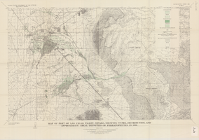
Maps of flood-prone areas in Las Vegas, Nevada, 1973
Date
1973
Description
'Prepared by the U.S. Department of the Interior, Geological Survey, in cooperation with the U.S. Department of Housing and Urban Development, Federal Insurance Administration. 1973.' Sheet 1: Las Vegas NE, Nev.; Sheet 2: Las Vegas SE, Nev.; Sheet 3:Las Vegas SW, Nev.; Sheet 4: Las Vegas NW, Nev. Published by Geological Survey (U.S.). Scale 1:24,000. [1 in. to approx. 2,000 ft.]. Relief shown by contours. Flood information overprinted on U.S. Geological Survey 7.5 minute topographic quadrangles: [sheet 1] Las Vegas NE quadrangle, [sheet 2] Las Vegas SE quadrangle, [sheet 3] Las Vegas SW quadrangle, [sheet 4] Las Vegas NW quadrangle, 1967. Shows areas subject to flooding by a flood that has 1 in 100 chance on the average of occurring in any one year. "Flood boundaries were estimated from: regional stage-frequency relations." Includes notes.
Image
Map of part of Las Vegas Valley, Nevada, showing changes in the piezometric surface between February 1944 and February 1956
Date
1965
Description
Scale 1:62,500 (W 115°15´--W 114°45´/N 36°30´--N 36°00´). 1 map : col. ; 58 x 70 cm. Series: Water-supply paper (Washington, D.C.) ; 1780. Relief shown by contours. Originally published as plate 6 of Available water supply of the Las Vegas ground-water basin, Nevada, by Glenn T. Malmberg, published by the Geological Survey in 1965 as its Water-supply paper 1780. Includes township and range lines. Interior, Geological Survey
Image
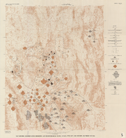
Map showing ground-water chemistry and hydrochemical facies, Nevada Test Site and vicinity, southern Nevada, 1965
Date
1965
Description
'United States Department of the Interior, Geological Survey. Professional paper 712-C, plate 3.' 'Prepared on behalf of the Atomic Energy Commission.' 'Base from U.S. Geological Survey Caliente, Death Valley, Goldfield, and Las Vegas, 1954.' 'Hydrochemistry by I. J. Winograd, 1965.' 'Interior--Geological Survey, Reston, Virginia--1975.' Relief shown by contours. Contour interval 200 feet. Shows township and range lines. Scale 1:250,000 (W 117°--W 115°/N 38°--N 36°). Series: Professional paper (Geological Survey (U.S.))712-C. Issued as plate 3 from U.S. Geological Survey professional paper 712-C, Hydrogeologic and hydrochemical framework, south-central Great Basin, Nevada-California, with special reference to the Nevada Test Site, by I.J. Winograd, and William Thordarson, published in 1975 by the U.S. Geological Survey.
Image
Map of part of Las Vegas Valley, Nevada, showing types, distribution, and approximate areal densities of phreatophytes in 1955
Date
1965
Description
Genre/Form: Thematic maps. Scale 1:62,500 (W 115°15´--W 114°45´/N 36°15´--N 36°00´). 1 map : col. ; 45 x 72 cm. Series: Water-supply paper (Washington, D.C.) ; 1780. Relief shown by contours. Originally published as plate 9 of Available water supply of the Las Vegas ground-water basin, Nevada, by Glenn T. Malmberg, published by the Geological Survey in 1965 as its Water-supply paper 1780. Includes township and range lines. Interior, Geological Survey
Image
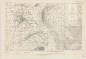
Map of part of Las Vegas Valley, Nevada, showing approximate area of phreatophytes before ground-water development
Date
1965
Description
Genre/Form: Thematic maps. Scale 1:62,500 (W 115°15´--W 114°45´/N 36°15´--N 36°00´). 1 map : col. ; 44 x 72 cm. Series: Water-supply paper (Washington, D.C.) ; 1780. Relief shown by contours. Originally published as plate 10 of Available water supply of the Las Vegas ground-water basin, Nevada, by Glenn T. Malmberg, published by the Geological Survey in 1965 as its Water-supply paper 1780. Includes township and range lines. Interior, Geological Survey
Image