Search Results
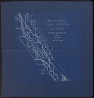
Map of Moapa Valley flood channel drainage program for 1940
Date
1940
Archival Collection
Description
Scale [ca. 1:63,360]. 1 in.=1 mile. Blueprint.
Image

Blueprint map showing proposed changes to water system, Las Vegas Land & Water Co., Las Vegas, Nevada, circa 1936
Date
1931 to 1941
Archival Collection
Description
'U.P.C. Co. #1799.31-T3-L3.'
Image
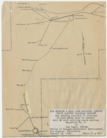
Map showing location of proposed 12-inch water main to connect Well #8 with settling basin serving Reservoir No. 2 at Las Vegas, Nevada, January 16, 1950
Date
1950-01-16
Archival Collection
Description
'Office of Manager-Industrial Development, Los Angeles, California.' Scale: 1" = 600'. 10 3/8 in. x 8 in.
Image
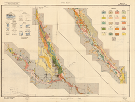
Soil map, Nevada, Moapa Valley sheet, 1923
Date
1923
Archival Collection
Description
'U.S. Department of Agriculture, Bureau of Chemistry and Soils; C.A. Browne, Acting Chief; Curtis F. Marbut, in charge, Soil Survey.' 'Macy H. Lapham, Inspector, District 5. Soils surveyed by F.O. Youngs, in charge, and E.J. Carpenter.' 'Field Operations, Bureau of Soils, 1923.' 'A, Hoen & Co. Lith. Baltimore, Md.' Shows township and range lines. Scale [1:63,360]. 1 in. = 1 mile (W 114°45´--W 114°18´/N 36°51´--N 36°24´). Library's copy has hand-written notes and has hand-drawn maps and notes on verso.
Image
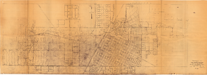
Topographic map of Las Vegas Rancho, showing location of wells and water lines, Las Vegas, Nev., October 18, 1946
Date
1946-10-18
Archival Collection
Description
'May 1, 1940. Revised Oct. 18, 1946.' 'F-225.' Relief shown by contours. Scale [ca. 1:7,200] 1 in.=600 feet.
Image
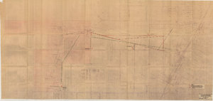
Map of Las Vegas Valley Water District, December 29, 1952
Date
1952-12-29
Archival Collection
Description
'Exhibit A.' 'Dec. 29, 1952.' 'I-128.' Scale [ca. 1:3,600]. 1 in.=300 feet. Shows water pipelines, other parts of the water system, and power lines to be removed or relocated when land is sold to the Las Vegas Valley Water District. Shows land to be sold and lists power requirements for water system. Includes township and range lines. Library's copy includes hand-written notations and calculations. Los Angeles & Salt Lake Railroad Company, Office of Vice President?
Image
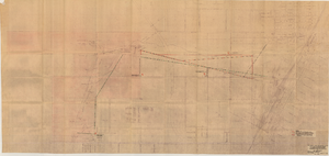
Map showing proposed relocation or removal of existing water transmission mains and power lines at Las Vegas, Nevada, June 3, 1952
Date
1952-06-03
Archival Collection
Description
'Los Angeles & Salt Lake Railroad Company. Union Pacific Railroad Company. Office of Vice President, Los Angeles, California, June 3, 1952.' 'Dwg. I-128.' Also shows location of land area proposed to be sold to the Las Vegas Valley Water District. Shows other parts of the water system and lists power requirements for water system. Includes township and range lines. Scale [ca. 1:3,600]. 1 in.=300 feet. Library's copy 2 is missing compass on right edge of page and has 'Limits of land which District proposes to buy, 507 Ac.' hand-printed in pencil and area is outlined in red.
Image
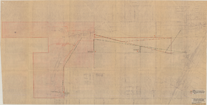
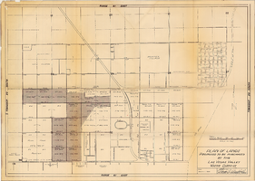
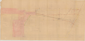
Plan of lands proposed to be purchased by the Las Vegas Valley Water District, August 1, 1952
Date
1952-08-01
Archival Collection
Description
'Date: August 1, 1952. Approved, Thomas A. Campbell, Pres.' Scale: [1 in.=approx. 300 feet]. Library's copy 2 has additional areas shaded, with original shaded areas outlined in red, plus various handwritten notations in pencil.
Image