Search Results

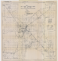
Topographic survey map of State Office Complex vicinity, September 25, 1970
Date
1970-09-25
Description
Blueline map, 74 x 110 cm. "Portion SE? SW? Section 27, Township 20 south, Range 61 east, M.D.M. & M., City of Las Vegas, Nev." "This survey was completed on September 25, 1970, at the instance of the state of Nevada Planning Board and correctly shows the elevation of all buildings and other structures." Shows City of Las Vegas Library, Dula Center, Nevada Highway Patrol building, YMCA. and State of Nevada Office Building. Library's copy is missing the lower right corner. Stamped in lower right-hand corner "Stephen F. Turner, Registered land surveyor - State of Nevada, No. 1803."
Image
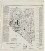
Map of Las Vegas artesian basin, Clark County, Nevada, April 1946 (Water Resources Bulletin no. 4, plate 1)
Date
1946-04
Description
'April, 1946.' 'Showing location of wells, springs, and boundary between valley fill and bedrock.' Originally published as plate 1 in number 4 of the Water resources bulletin published by the Nevada Office of the State Engineer. Scale [ca. 1:63,360. 1 in. to approx. 1 mile] (W 115°10?--N 115°/N 36°20?--N 36°). G4354.L3C34 1946 .N482
Image
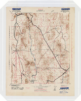
Earthquake epicenter map of Nevada, December 1964
Date
1964-12
Description
Scale 1:1,000,000 (W 120°--W 114°/N 42°--N 35°). Title in upper right margin: Earthquake epicenter map ; "Nevada earthquake epicenters for the period from about 1852 to 1961 are plotted on the accompanying map." ; "Contour interval 1,000 feet." ; "Supported by grant no. AF-AFOSR-62-285 of the Air Force of Scientific Research." ; "December 1964." ; "Base from NBM Map 17." ; "One million scale set." ; Includes bibliographical references ; Includes text and index. Nevada Bureau of Mines, University of Nevada
Text
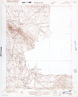
Topographic map of the Camp Mohave quadrangle in California, Nevada and Arizona, 1942
Date
1942
Description
Scale 1;250,000 ; polyconic projection (W 115°--W 114V/N 36V--N 35V) ; 1 map : col. ; 52 x 37 cm ; Relief shown by contours and spot heights. Contour interval 250 feet ; "Training map"--Center of upper margin of map ; "Base compiled from U.S. Geological Survey quadrangles. Control from U.S. Geological Survey. Revised from state highway maps for Arizona, Nevada and California" ; "Culture revisions shown in red based on reconnaissance by 67th Engr. Co. (Top.). May not be of same accuracy as base map." ; Map shows roads, trails, ponton sites, dam sites, possible air fields, possible landing fields, airports, water points, and impassable areas ; Map was originally restricted. "Classification cancelled by authority of Chief of Engineers letter of Jan. 22, 1946." ; Title at top of map: Nevada-Arizona-California : Camp Mohave quadrangle : grid zone F ; Army Map Service, U.S. Army.
Image
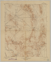
Map of Kawich Quadrangle, Nye County, Nevada, June 1908
Date
1908-06
Description
At upper left corner: 'Department of the Interior, U.S. Geological Survey.' 'E. M. Douglas, geographer; R. G. Chapman, in charge of section; triangulation and topography by R. H. Chapman and B. D. Stewart. Surveyed in 1905.' 'Engraved April 1906 by U.S.G.S.' 'Edition of June 1908, repritned 1929.' 'Polyconic projection. North American datum.' Guide to Topographic Maps of the United States series on map verso. UNLV Special Collections Southern Nevada Mining Map Collection
Text

Map of well locations, Las Vegas Valley, Nevada, 1975
Date
1976
Description
'Cartography by Marj Thielke.' 'Prepared in cooperation with the State of Nevada, Department of Conservation and Natural Resources, Division of Water Resources.' Relief shown by contours. Shows township and range lines. Originally published as Plate 1 in Water-level changes associated with ground-water development in Las Vegas Valley, Nevada, 1971-75 : fourth progress report--summary of data / by James R. Harrill, published in 1976 by the Department of Conservation and Natural Resources, Division of Water Resources, as volume 22 of Water resources-information series report. Scale [ca. 1:69,696. 1 in.=approx. 1.1 miles] (W 115°20´--W 115°00´/N 36°20´--N 36°00´).
Image
Map of Ely Range Quadrangle, Lincoln County, Nevada, 1921
Date
1921
Description
'Edition of 1921.' 'W. H. Herron, Acting Chief Geographer; Geo. R. Davis, Geographer In Charge; Topography by H. H. Hodgeson, N. E. Ballmer, and W. B. Upton, Jr.; Control by H. H. Hodgeson, Roscoe Reeves, and D. S. Birkett. Surveyed in 1916.' At top of map: ' Topography, State of Nevada.' At upper left corner: ' Department of the Interior, Albert B. Fall, Secretary; U.S. Geological Survey, George Otis Smith, Director.' Southern Nevada Mining Map Collection. 15 minute series (topographic) Nevada.
Image
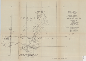
Wagon road from Fort Steele, Wyoming via Rawlins, Union Pacific R.R. to White River Agency, Colo., via cut-off from old road, October, 1878
Date
1878-10
Description
38 x 52 cm. "Topography: Colorado & Utah: U.S. Geolog. Survey Territories, Prof. Hayden in charge and from personal notes & obs--Wyoming: maps, General Land Office & personal notes." "October, 1878." Includes other wagon roads, trails, rivers, ranches, Indian agencies and military reservation. "Drawn by Lieutenant C. A. H. McCauley, 3rd Artillery." "Sen. Ex. Doc. No. 62, 45th Congress 3rd Sess." Original publisher: GPO, Series: Sen. ex. doc no. 62, 45th Congress, 3rd session.
Image
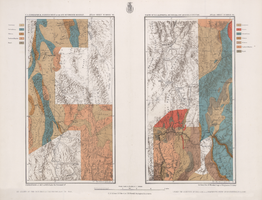
Maps of geographical surveys of parts of California, southeastern Nevada, Arizona and southwestern Utah, made under the command of George M. Wheeler, 1872-1873
Date
1872 to 1873
Description
At top of plate: 'U.S. geographical surveys west of the one-hundredth meridian. Parts of California, S.E. Nevada, Arizona & S.W. Utah.' At bottom of plate: 'Expeditions of 1872 & 1873, under the command of 1st Lieut. Geo. M. Wheeler, Corps of Engineers, U.S. Army.' 'G. K. Gilbert, A. R. Marvine, E. E. Howell, geological assistants.' 'By order of The Honorable The Secretary of War, under the direction of Brig. Gen. A. A. Humphries, Chief of Engineers, U.S. Army.' Published by Government Printing Office. 2 map sections on 1 sheet. Scale: 1 inch to 8 miles.
Image

Map showing parts of eastern and southeastern Nevada and southwestern Utah, circa 1873
Date
1869
1872 to 1873
Archival Collection
Description
Scale 1:506,880. 1 in. to 8 miles (W 117°30--W 114°45/N 37°20--N 40°00). Relief shown by hachures and spot heights. At top left: 'Explorations & surveys west of the one-hundredth meridian.' At top right: 'Parts of Eastern & Southeastern Nevada & Southwestern Utah. Atlas sheet number 66.' At bottom left: 'Expeditions of 1869, 1872 & 1873.' At bottom right: ' 1st Lieut. Geo. M. Wheeler, Corps of Engineers, com'd'g.' Seal of the War Department, Corps of Engineers, U.S. Army at top center of map. Originally published as part of the geological atlas which is an appendix to the Survey's Report upon United States geographical surveys west of the one hundredth meridian, published in 1876?
Image