Search Results

Topographic map of the southwestern quadrangle of the metropolitan Las Vegas, Nevada area, 1973
Date
Description
Image

Topographic map of the northeast quadrangle of the metropolitan Las Vegas, Nevada area, 1973
Date
Description
Image

Topographic map of the northwest quadrangle of the metropolitan Las Vegas, Nevada area, 1973
Date
Description
Image

Topographic map of the southeast quadrangle of the metropolitan Las Vegas, Nevada area, 1973
Date
Description
Image
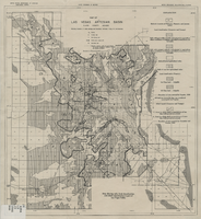
Map of Las Vegas artesian basin, Clark County, Nevada, April 1946 (Water Resources Bulletin no. 5, plate 5)
Date
Description
Image

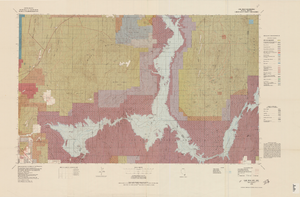
Topographic map of the southeast quadrangle of the metropolitan Las Vegas, Nevada area, 1984
Date
Description
Image
Topographic map of Lake Mead quadrangle, Nevada and Arizona, 1979
Date
Description
Image
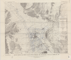
Map of part of Las Vegas Valley, Nevada, showing the piezometric surface in February 1955
Date
Description
Relief shown by contours. Includes township and range lines. Scale 1:96,000 (W 115°30´--W 114°45´/N 36°30´--N 36°00´). Series: Water-supply paper (Washington, D.C.)
1780. Originally published as plate 3 of Available water supply of the Las Vegas ground-water basin, Nevada, by Glenn T. Malmberg, published by the Geological Survey in 1965 as its Water-supply paper 1780.
Image
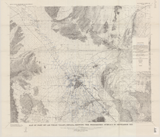
Map of part of Las Vegas Valley, Nevada, showing the piezometric surface in September 1955
Date
Description
Relief shown by contours. Includes township and range lines. Scale 1:96,000 (W 115°30´--W 114°45´/N 36°30´--N 36°00´). Series: Water-supply paper (Washington, D.C.)
1780. Originally published as plate 4 of Available water supply of the Las Vegas ground-water basin, Nevada, by Glenn T. Malmberg, published by the Geological Survey in 1965 as its Water-supply paper 1780.
Image

Topographic map of the Las Vegas Valley area, 1959
Date
Description
Image