Search Results

Geologic map of the Dead Horse Flat quadrangle, Nye County, Nevada, 1967
Date
1967
Description
58 x 46 cm., on sheet 77 x 84 cm., folded in envelope 30 x 24 cm. Relief shown by contours and spot heights. "Base by U.S. Geological Survey, 1960." "Geology mapped in 1962-64." "Contour interval 20 feet." Includes 2 col. cross sections, quadrangle location map, and text. "Prepared in cooperation with the U. S. Atomic Commission." Original publisher: Interior, Geological Survey, Series: Geologic quadrangle map GQ, Scale: 1:24 000.
Image
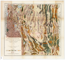
Geological reconnaissance map of Nevada south of the 40th parallel and adjacent California, 1903
Date
1903
Description
'Compiled from all available information by J.E. Spurr. Topographic base chiefly adapted from the maps of the Wheeler Survey.' 'U.S. Geological Survey, Bulletin No. 208, Pl. 1.' 'A. Hoen & Co. Lith. Baltimore, MD.' Relief shown by hachures and spot heights. Scale [ca. 1:950,000. 1 inch to approximately 15 miles] (W 120°--W 114°/N 40°--N 36°). Geological Survey bulletin, 208.
Image
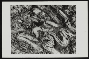
View of geologic folding: photographic print
Date
1910 (year approximate) to 1930 (year approximate)
Archival Collection
Description
From the Chester R. Longwell Photograph Collection (PH-00311)
Image
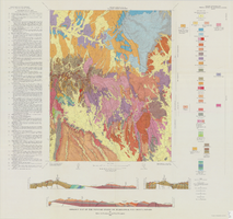
Geologic map of the Topopah Spring NW quadrangle, Nye County, Nevada, 1965
Date
1965
Description
58 x 47 cm., on sheet 84 x 89 cm., folded in envelope 30 x 24 cm. Relief shown by contours and spot heights. "Contour interval 20 feet." "Prepared in cooperation with the U. S. Atomic Energy Commission." "Geology mapped by R. L. Christiansen, P. W. Lipman, and H. R. Cornwall, 1962." Includes text, 3 col. cross sections, and quadrangle location map. Original publisher: Interior, Geological Survey, Series: Geologic quadrangle map GQ, Scale: 1:24 000.
Image
Geologic research, 1994
Level of Description
File
Archival Collection
David Donovan Collection on Hydrology and Geology
To request this item in person:
Collection Number: MS-00813
Collection Name: David Donovan Collection on Hydrology and Geology
Box/Folder: Box 63
Collection Name: David Donovan Collection on Hydrology and Geology
Box/Folder: Box 63
Archival Component
Geology and Uranou , 1975
Level of Description
File
Archival Collection
David Donovan Collection on Hydrology and Geology
To request this item in person:
Collection Number: MS-00813
Collection Name: David Donovan Collection on Hydrology and Geology
Box/Folder: Box 27
Collection Name: David Donovan Collection on Hydrology and Geology
Box/Folder: Box 27
Archival Component
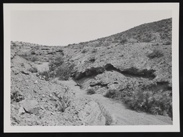
Geologic formations southeast of Boulder City, image 004: photographic print
Date
1930 (year uncertain) to 1933 (year uncertain)
Archival Collection
Description
Geologic formations southeast of Boulder City, Nevada.
Image
General geological papers, approximately 1919 to 1951
Level of Description
Series
Scope and Contents
The Franklin M. Murphy General Geological Papers (1919-1951) contain university grades, thesis, and other papers written by Murphy. Also included are proposals, correspondence, newspaper clippings, maps, notes, and geological findings relating to mining and water.
Archival Collection
Franklin M. Murphy Geological Papers
To request this item in person:
Collection Number: MS-00202
Collection Name: Franklin M. Murphy Geological Papers
Box/Folder: N/A
Collection Name: Franklin M. Murphy Geological Papers
Box/Folder: N/A
Archival Component

Geologic map of the Paiute Ridge quadrangle, Nye and Lincoln Counties, Nevada, 1967
Date
1967
Description
58 x 46 cm., on sheet 85 x 83 cm., fold. in envelope 30 x 24 cm. Relief shown by contours and spot heights. "Contour interval 20 feet." "Prepared in cooperation with the U.S. Atomic Energy Commission." "Geology mapped in 1961. Contours on pre-Tertiary rocks by D. L. Healey and C. H. Miller, 1963." Includes text, 4 col. cross sections, and quadrangle location map. Original publisher: U. S. Geological Survey, Series: Geologic quadrangle map GQ, Scale: 1:24 000.
Image

Geologic map of the Jangle Ridge quadrangle, Nye and Lincoln Counties, Nevada, 1965
Date
1965
Description
58 x 46 cm., on sheet 84 x 87 cm., folded in envelope 30 x 24 cm. Relief shown by contours and spot heights. "Contour interval 20 feet." "Prepared in cooperation with the U.S. Atomic Energy Commission." "Geology mapped in 1961. Limit of pluvial Groom Lake and faults from photographs mapped by R. B. Colton, 1962." Includes text, bibliography, location map, and 5 col. cross sections. Original publisher: Interior, U.S. Geological Survey, Series: Geologic quadrangle map GQ, Scale: 1:24 000.
Image