Search Results
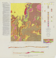
Geologic map of the Quartet Dome quadrangle, Nye County, Nevada, 1966
Date
1966
Description
58 x 46 cm., on sheet 88 x 85 cm., folded in envelope 30 x 24 cm. Relief shown by contours and spot heights. "Contour interval 20 feet." "Base by U.S. Geological Survey, 1962, 10,000-foot grid based on Nevada coordinate system, central zone." "Geology mapped in 1962-63." Includes 2 col. cross sections, diagrammetric stratigraphic section, quadrangle location map, and text. "Prepared in cooperation with the U.S. Atomic Energy Commission." Original publisher: Interior, Geological Survey, Series: Geologic quadrangle map GQ, Scale: 1:24 000.
Image
Hydrogeology, the Geology of North America, The Geological Society of America, 1988
Level of Description
File
Archival Collection
David Donovan Collection on Hydrology and Geology
To request this item in person:
Collection Number: MS-00813
Collection Name: David Donovan Collection on Hydrology and Geology
Box/Folder: Box 41
Collection Name: David Donovan Collection on Hydrology and Geology
Box/Folder: Box 41
Archival Component
Geology of Nevada, a book by the Nevada Bureau of Mines and Geology, 1980
Level of Description
File
Archival Collection
David Donovan Collection on Hydrology and Geology
To request this item in person:
Collection Number: MS-00813
Collection Name: David Donovan Collection on Hydrology and Geology
Box/Folder: Box 04
Collection Name: David Donovan Collection on Hydrology and Geology
Box/Folder: Box 04
Archival Component
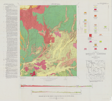
Geologic map of the Thirsty Canyon quadrangle, Nye County, Nevada, 1966
Date
1966
Description
57 x 46 cm., on sheet 83 x 91 cm., folded in envelope 30 x 24 cm. Relief shown by contours and spot heights. "Geology mapped in 1963." Includes 2 colored cross sections, index map, text, and quadrangle location map. "Prepared in cooperation with the U. S. Atomic Commission." Original publisher: Interior, Geological Survey, Series: Geologic quadrangle map GQ, Scale: 1:24 000.
Image
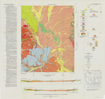
Geologic map of the Belted Peak quadrangle, Nye County, Nevada, 1967
Date
1967
Description
45 x 36 cm., on sheet 64 x 89 cm., fold. in envelope 30 x 24 cm. Relief shown by contours and spot heights. "Contour interval 40 feet." "Prepared in cooperation with the U.S. Atomic Energy Commission." "Geology mapped in 1962-63." Includes text, 2 col. cross sections, and quadrangle location map. Original publisher: U.S. Geological Survey, Series: Geologic quadrangle map GQ, Scale: 1:62 500.
Image
Geologic map of the Buckboard Mesa quadrangle, Nye County, Nevada, 1966
Date
1966
Description
58 x 46 cm., on sheet 87 x 91 cm., folded in envelope 30 x 24 cm. Relief shown by contours and spot heights. "Contour interval 20 feet." "Prepared in cooperation with the U.S. Atomic Energy Commission." "Geology mapped in 1962-63." Includes text, 2 col. cross sections, and 2 index maps. Original publisher: U.S. Geological Survey, Series: Geologic quadrangle map GQ, Scale: 1:24 000.
Image

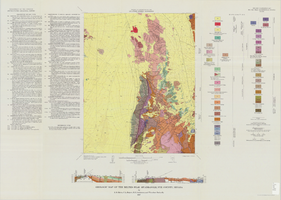
Geologic map of the Topopah Spring quadrangle, Nye County, Nevada, 1970
Date
1970
Description
58 x 46 cm., on sheet 84 x 88 cm., folded in envelope 30 x 24 cm. Relief shown by contours and spot heights. "Geology mapped in 1962-63." Includes description of map units, colored columnar section, 3 colored cross sections, and quadrangle location map. "Prepared in cooperation with the U. S. Atomic Commission." Original publisher: Interior, Geological Survey, Series: Geologic quadrangle map GQ, Scale: 1:24 000.
Image

Geologic map of the Tippipah Spring quadrangle, Nye County, Nevada, 1963
Date
1963
Description
58 x 46 cm., on sheet 84 x 81 cm., folded in envelope 30 x 24 cm. Relief shown by contours and spot heights. "Geology by P.P. Orkild, 1959-60, paleotopography by D.L. Healey and C.H. Miller, 1959-60." Series statement from envelope. Includes description of map units, 2 col. cross sections, and quadrangle location map. "Prepared in cooperation with the U. S. Atomic Commission." Original publisher: Interior, Geological Survey, Series: Geologic quadrangle map GQ, Scale: 1:24 000.
Image
Franklin M. Murphy Geological Papers
Identifier
MS-00202
Abstract
The Franklin M. Murphy Geological Papers (1919-1956) contain surveys, lectures, reports, correspondence, newspaper clippings, bulletins, maps, and dam site investigations from six different states in the American west. Also included are mining projects, photographs, scrapbooks, albums, school papers, and Murphy's thesis.
Archival Collection
Geology reports
Level of Description
File
Archival Collection
Yucca Mountain Environmental Safety Reports Collection
To request this item in person:
Collection Number: MS-00786
Collection Name: Yucca Mountain Environmental Safety Reports Collection
Box/Folder: N/A
Collection Name: Yucca Mountain Environmental Safety Reports Collection
Box/Folder: N/A
Archival Component