Search Results
Geology Workshop, 1991
Level of Description
Archival Collection
Collection Name: Frontier Girl Scouts Records
Box/Folder: Box 01
Archival Component
Geology, 1972-1973
Level of Description
Archival Collection
Collection Name: North Las Vegas Library District Collection on Nevada
Box/Folder: Box 09
Archival Component
Geology, 1949-1963
Level of Description
Archival Collection
Collection Name: Las Vegas Library Regional History Files Collection
Box/Folder: Box 10
Archival Component

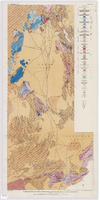
Geologic map of the Ammonia Tanks quadrangle, Nye County, Nevada, 1967
Date
Description
Image
Preliminary Geologic Map of the Moores Station Quadrangle, Nevada - USDOI, Geological Survey, 1970
Level of Description
Archival Collection
Collection Name: Yucca Mountain Site Characterization Office Collection
Box/Folder: Box 74
Archival Component
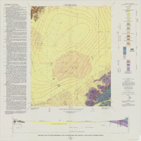
Geologic map of the Atomic Energy Commission Nevada Proving Grounds Area, Nye and Clark Counties, Nevada, 1952
Date
Description
'At top of map: ' United States Department of the Interior. Geological Survey.' ' Bulletin 1021, Plate 32.' At bottom of map: 'Geology by Donald E. Hibbard and Mike S. Johnson, 1952.' 'Base from USAF Aeronautical Chart and Information Service, April 1952.' 'Interior--Geological Survey, Washington, D.C. MR-3767.' Scale 1:63,360 (W 116°10--W 115°55/N 37°15--N 36°40)
Geological Survey bulletin, 1021
Image
Geologic map of the Frenchman Flat quadrangle, Nye, Lincoln, and Clark Counties, Nevada, 1965
Date
Description
Image
Geologic Tours in the Las Vegas Area, Expanded Edition, Nevada Bureau of Mines and Geology, 2001
Level of Description
Archival Collection
Collection Name: David Donovan Collection on Hydrology and Geology
Box/Folder: Box 35
Archival Component
Geological Survey Research, 1970
Level of Description
Archival Collection
Collection Name: David Donovan Collection on Hydrology and Geology
Box/Folder: Box 60
Archival Component
Geology and water resources, 2007
Level of Description
Archival Collection
Collection Name: David Donovan Collection on Hydrology and Geology
Box/Folder: Box 11
Archival Component