Search Results

Las Vegas SW quadrangle
Date
1973
Description
'Prepared by the U.S. Department of the Interior, Geological Survey, in cooperation with the U.S. Department of Housing and Urban Development, Federal Insurance Administration. 1973.'
Image

Map of well locations, Las Vegas Valley, Nevada, 1975
Date
1976
Description
'Cartography by Marj Thielke.' 'Prepared in cooperation with the State of Nevada, Department of Conservation and Natural Resources, Division of Water Resources.' Relief shown by contours. Shows township and range lines. Originally published as Plate 1 in Water-level changes associated with ground-water development in Las Vegas Valley, Nevada, 1971-75 : fourth progress report--summary of data / by James R. Harrill, published in 1976 by the Department of Conservation and Natural Resources, Division of Water Resources, as volume 22 of Water resources-information series report. Scale [ca. 1:69,696. 1 in.=approx. 1.1 miles] (W 115°20´--W 115°00´/N 36°20´--N 36°00´).
Image
T-Shirt Color: Navy Blue; Front: Chicago Police, State seal; Handwritten Text: The Following Officers From 006 Salute Our Heroes From 9-11-01: Bill Sweeney, Laura Sweeney, J. Wynn, J. Wilson, J. Hickey, J. Almonza, A. Cercers, Mile, Franco, K. Keel,, approximately 2001-2012
Level of Description
File
Archival Collection
New York-New York Hotel and Casino 9-11 Heroes Tribute Collection
To request this item in person:
Collection Number: MS-00459
Collection Name: New York-New York Hotel and Casino 9-11 Heroes Tribute Collection
Box/Folder: Box 377
Collection Name: New York-New York Hotel and Casino 9-11 Heroes Tribute Collection
Box/Folder: Box 377
Archival Component

Redevelopment plan map for downtown Las Vegas, Nevada, November 18, 1987
Date
1987-11-18
Description
Scale [ca. 1:12,000. 1 inch equals approx. 1,000 feet]. 1 map ; on sheet 61 x 46 cm. "Nov. 18, 1987." "All land use designations on this map are to be interpreted in conformance with the community profiles component of the Las Vegas General Plan." City of Las Vegas?.
Image

Plat showing original townsite and subdivisions, Las Vegas, Lincoln County, Nevada, May 1905
Date
1905-05
Description
Land owned by the San Pedro, Los Angeles & Salt Lake Railroad is outlined. Scale: [ca. 1:12,000]. 1 inch = 1,000 feet. Cadastral map. Blueline print. Additional copy available in the J.T. McWilliams manuscript collection
Image

Map of the Las Vegas Strip, May 1950
Date
1950-05
Description
Scale [ca. 1:10,200. 1 in. to approx. 850 ft.] ; 1 map : col. ; 54 x 28 cm ; Cadastral map ; "May 1950." Campbell Realty.
Image

Map of Las Vegas Valley showing artesian wells, circa 1920
Date
1918 to 1922
Description
Scale not given ; 1 map ; 66 x 55 cm ; Blueline print ; Cadastral map ; Includes township and range grid ; Includes quotations McWilliams?
Image
#69217: Students from around the U.S. participating in the National Junior Classical League convention run a foot race around campus as a nod to Pheidippides' run from Marathon to Athens following the Battle of Marathon in 490 B.C. The annual gathering of Classics students was hosted by UNLV, July 24, 2013, 2013 July 24
Level of Description
File
Archival Collection
University of Nevada, Las Vegas Creative Services Records (2010s)
To request this item in person:
Collection Number: PH-00388-05
Collection Name: University of Nevada, Las Vegas Creative Services Records (2010s)
Box/Folder: Digital File 00
Collection Name: University of Nevada, Las Vegas Creative Services Records (2010s)
Box/Folder: Digital File 00
Archival Component
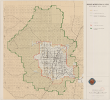
Map showing proposed metropolitan Las Vegas development area, June 24, 1997
Date
1997-06-24
Description
'Data sources: Advanced Planning Division, Clark County, Nevada.' 'Comprehensive Planning, Advanced Planning Division.' 'June 24, 1997.' Shows federal land, metropolitan Las Vegas development area, Las Vegas urban growth boundary and section lines. Scale [ca. 1:154,056. 1 inch to approx. 12,838 feet].
Image